
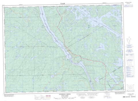
031L14 Ottertail Creek Canada topo map, 1:50,000 scale
031L14 Ottertail Creek NRCAN topographic map.
Includes UTM and GPS geographic coordinates (latitude and longitude). This 50k scale map is suitable for hiking, camping, and exploring, or you could frame it as a wall map.
Printed on-demand using high resolution, on heavy weight and acid free paper, or as an upgrade on a variety of synthetic materials.
Topos available on paper, Waterproof, Poly, or Tyvek. Usually shipping rolled, unless combined with other folded maps in one order.
- Product Number: NRCAN-031L14
- Parent Topo: TOPO-031L
- Map ID also known as: 031L14, 31L14
- Unfolded Size: Approximately 26" high by 36" wide
- Weight (paper map): ca. 55 grams
- Map Type: POD NRCAN Topographic Map
- Map Scale: 1:50,000
- Geographical region: Ontario, Canada
Neighboring Maps:
All neighboring Canadian topo maps are available for sale online at 1:50,000 scale.
Purchase the smaller scale map covering this area: Topo-031L
Spatial coverage:
Topo map sheet 031L14 Ottertail Creek covers the following places:
- Baie Belleperche - Baie Black - Baie Bloc - Baie Chapoton - Baie de la Ferme - Baie des Anglais - Baie des Neuf Milles - Baie Deshêtres - Baie Dorval - Baie du Canal - Baie Gibson - Baie Giguère - Baie Goguet - Baie Hay - Baie Hoonan - Baie Jawbone - Baie Marquet - Baie McLaren - Baie Murtagh - Baie Perley - Baie Pillette - Baie Russell - Baie Sandy - Baie Snedden - Baie Stenhouse - Baie Thompson - Baie Thompson - Crique de la Loutre - Grand Campment Bay - McLaren Bay - McLarens Bay - McLaren's Bay - Plage Temkim - McLaren Point - McLarens Point - McLaren's Point - Pine Tree Point - Pinetree Point - Pointe Antoine - Pointe des Neuf Milles - Pointe Martin - Pointe McMartin - Pointe Opimica - Pointe Ouellette - Chenal Kipawa - Chenal Opimica - Le Canal - Opimika Narrows - Passe Fox - Angus - Atwater - Bruchési - Burnaby - Gendreau - Hebert - La Salle - Mazenod - McAuslan - Mercier - Nipissing - Notre-Dame-du-Lac - Parkman - Shehyn - Tabaret - Wyse - Barrage Marsac - Barrage Tee - Île à l'Orignal - Île au Chevreuil - Île aux Fraises - Île aux Pins - Île Brûlée - Île Clermont - Île de la Ferme - Île de la Souris - Île du Club Wabinning - Île Fox - Île McKenzie - Île Nasiouade - Île Waubining - Îles du Sandy Portage - Baie Coalpit - Biber Lake - Big Webb Lake - Blue Lake - Boland Lake - Brute Lake - Burnaby Lake - Camp Lake - Cut Lake - Elbow Lake - Emerald Lake - God's Lake - Green Lake - Greenwood Lake - Hartle Lake - Hidden Lake - Intersection Lake - Lac à la Truite - Lac à la Truite - Lac à Simard - Lac aux Castors - Lac aux Ménés - Lac Bass - Lac Bass - Lac Bellemare - Lac Bibeau - Lac Boldies - Lac Croche - Lac Croche - Lac Crooked - Lac de la Lune - Lac de l'Ours Blanc - Lac des Aigles - Lac des Baies - Lac des Îles - Lac du Moulin - Lac Gordon - Lac Jadot - Lac Kipawa - Lac Lafeuillade - Lac Long - Lac Long - Lac Long - Lac Loon - Lac Lost - Lac Lost - Lac Mallet - Lac Marot - Lac Marsac - Lac Nadeau - Lac Orignal - Lac Pond - Lac Ponu - Lac Ravalet - Lac Star - Lac T - Lac Tee - Lac Témiscamingue - Lac Témiscamingue - Lac Thiriot - Lac Vessière - Lac White - Lake Timiskaming - Lepage Lake - Line Lake - Little Brute Lake - Little Webb Lake - Maryann Lake - McConnell Lake - Modder Lake - Moose Pond - Muskeg Lake - Norway Lake - O'Brian Lake - Opimika Lake - Orient Lake - Otter Lake - Owain Lake - Pebbly Lake - Porcupine Lake - Raft Lake - Richer Lake - Round Lake - Secord Lake - Shallow Lake - Shanty Lake - Sonora Lake - Spider Lake - Spring Lake - Sure Catch Lake - Thibeault Lake - Troutbait Lake - Webb Lake - Halte Opimica - God's Lake Old Growth White Pine Forest Conservation Reserve - Ottertail Creek Conservation Reserve - Parc J.-R.-Booth - South Timiskaming Shoreline Conservation Reserve - Spring/Cut Lake Esker Conservation Reserve - Brute Creek - Green Creek - North Ottertail Creek - Opimika Creek - Ottawa River - Ottertail Creek - Owain Creek - Porcupine Creek - Rivière des Outaouais - Rivière des Outaouais - Rivière Kipawa - Rivière Opemicon - Rivière Ottawa - Ruisseau Blanc - Ruisseau Chemon - Ruisseau du Moulin Latour - Ruisseau Gordon - Ruisseau Lost - Ruisseau Marsac - Ruisseau White - Côte de la Faucille - Côte Sloan - Îlot du Chenal Principal - Baie-Dorval - Baie-Stenhouse - Dozois - Gendreau - Gendreau - McLarens Bay - McLaren's Bay - Pointe-Antoine - Tabaret - Tee Lake - Tee Lake - Kipawa - Letang


