
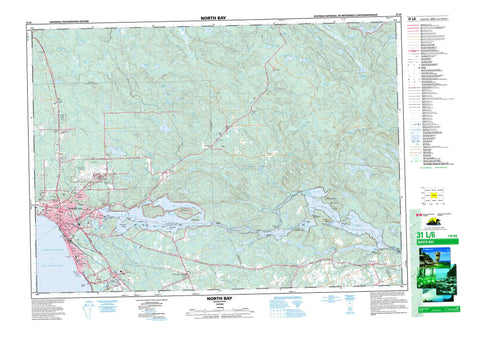
031L06 North Bay Canada topo map, 1:50,000 scale
031L06 North Bay NRCAN topographic map.
Includes UTM and GPS geographic coordinates (latitude and longitude). This 50k scale map is suitable for hiking, camping, and exploring, or you could frame it as a wall map.
Printed on-demand using high resolution, on heavy weight and acid free paper, or as an upgrade on a variety of synthetic materials.
Topos available on paper, Waterproof, Poly, or Tyvek. Usually shipping rolled, unless combined with other folded maps in one order.
- Product Number: NRCAN-031L06
- Parent Topo: TOPO-031L
- Map ID also known as: 031L06, 31L6, 31L06
- Unfolded Size: Approximately 26" high by 36" wide
- Weight (paper map): ca. 55 grams
- Map Type: POD NRCAN Topographic Map
- Map Scale: 1:50,000
- Geographical region: Ontario, Canada
Neighboring Maps:
All neighboring Canadian topo maps are available for sale online at 1:50,000 scale.
Purchase the smaller scale map covering this area: Topo-031L
Spatial coverage:
Topo map sheet 031L06 North Bay covers the following places:
- Baie Kaibuskong - Baie Shields - Cherries Bay - Delaney Bay - Dugas Bay - Four Mile Bay - Fourmile Bay - James Bay - Kaibuskong Bay - Lounsbury Bay - McCool Bay - Milnes Bay - One Mile Bay - Rice Bay - Shields Bay - Spottswood Bay - Bowles Point - Chapleau Point - Doran Point - First Rocky Point - Grasswell Point - Pilot Point - Rocky Point - Sampson Point - Second Rocky Point - Shields Point - St. Laurent Point - Sunset Point - The Narrows - North Bay - Red Pine Chute - Talon Chute - Antoine - Bonfield - Butler - Calvin - East Ferris - Ferris - French - Merrick - Mulock - Nipissing - Olrig - Phelps - West Ferris - Widdifield - Baltic Island - Camp Comfort Island - Camp Island - Cedar Island - Dave Island - Dellview Island - Dunn Island - Falconbridge Island - Fitzsimmons Island - Hemlock Island - Heyworth Island - Hughes Island - Joe Island - Kirkwood Island - Little Joe Island - Louisville Island - Medora Island - Murdoch Island - Payne Island - Poplar Island - Rolph Island - Shaftesbury Island - Stubbs Island - Three Sisters Islands - Trout Island - Wharton Island - Wharton Island - Antoine Lake - Barse Lake - Bell Lake - Bigfish Lake - Boivin Lake - Boot Lake - Brumal Lake - Burntshanty Lake - Bushtrail Lake - Cahill Lake - Camelot Lake - Caribou Lake - Carrigan Lake - Charron Lake - Chime Lake - Circle Lake - Clearspot Lake - Crescent Lake - Delaney Lake - Depensiers Lake - Dillow Lakes - Dinner Lake - Doule Lake - Dreany Lake - Duchesnay Lake - Eighty Acre Lake - Four Mile Lake - Fourmile Lake - Frair Lake - Francis Lake - Froggy Lake - Gauvreau Lake - Glassy Lake - Glen Lake - Green Lake - Hillside Lake - Indian Lake - Island Lake - Jennings Lake - Kaibuskong Lake - L Lake - La Chapelle Lake - Lac à Perron - Lac Cahill - Lac des Pins - Lac des Rapides Rouges - Lac Gauvreau - Lac Grenouille - Lac La Chapelle - Lac Nipissing - Lac Noir - Lac Rond - Lac Talon - Lac Tortue - Lake Nipissing - Lake Talon - Little Long Lake - Little Mountain Lake - Little Mulock Lake - Long Lake - Loren Lake - Lunch Lake - Magee Lake - McLean Lake - Moosegrass Lake - Mountain Lake - Moyer Lake - Nekik Lake - O'Kane Lake - Olmstead Lake - Otter Lake - Parks Lake - Pasmore Lake - Perron Lake - Pine Lake - Redbridge Lake - Reynolds Lake - Ring Lake - Robichaud Lake - Round Lake - Sheedy Lake - Skunk Lake - Teesdale Lake - Thirty Acre Lake - Tilliard Lake - Timber Lake - Trout Lake - Turcotte Lake - Turtle Lake - Twenty Minute Lake - Twin Lakes - Twinline Lakes - Two Mile Lake - Upper Pinewater Lake - Valin Lake - Walder Lake - Werwolf Lake - Whitethroat Lake - Widdifield Lake - Base des Forces canadiennes North Bay - Canadian Forces Base North Bay - Culebra Hill - Lafleur Hill - St. Laurent Hill - Thibeault Hill - Bonfield - Calvin - East Ferris - Ferris - West Ferris - Widdifield - Mattawa River Provincial Park - Widdifield Forest Provincial Park - Mauvaise Musique Rapids - Portage de la Musique - Antoine Creek - Balsam Creek - Blueseal Creek - Bushtrail Creek - Cahill Creek - Chippewa Creek - Cook Creek - Doran Creek - Doule Creek - Duchesnay Creek - Duchesnay River - East Balsam Creek - Four Mile Creek - Fourmile Creek - Francis Creek - Glassy Creek - Hogan Creek - Kaibuskong River - La Vase River - Lees Creek - Little North River - Little Pinewater Creek - Mattawa River - North River - Parks Creek - Pasmore Creek - Redbridge Creek - Rivière du Nord - Rivière Mattawa - Sharpes Creek - Spring Creek - Walder Creek - Widdifield Creek - The Forks - Portage de la Mauvaise Musique - Portage de Talon - Portage Pin de Musique - Stepping Stones - Three Sisters - Balsam Creek - Birch Haven - Blanchards Landing - Blanchard's Landing - Camey - Camp Champlain - Cooks Mills - Corbeil - Eastview - Feronia - Ferris - Fricker - Gateway - Graniteville - Hornell Heights - Lounsbury - Marshall Park - Mulock - Nipissing Junction - Pinewood - Pinewood Village - Redbridge - Renown - Rutherglen - Sage - Songis - Sunset Park - The Forks - Thibeault Terrace - Thorncliff - Trout Mills - Tweedsmuir - Tweedsmuir Village - Wallace Heights - Widdifield - Widdifield Station


