
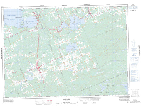
031L03 Powassan Canada topo map, 1:50,000 scale
031L03 Powassan NRCAN topographic map.
Includes UTM and GPS geographic coordinates (latitude and longitude). This 50k scale map is suitable for hiking, camping, and exploring, or you could frame it as a wall map.
Printed on-demand using high resolution, on heavy weight and acid free paper, or as an upgrade on a variety of synthetic materials.
Topos available on paper, Waterproof, Poly, or Tyvek. Usually shipping rolled, unless combined with other folded maps in one order.
- Product Number: NRCAN-031L03
- Parent Topo: TOPO-031L
- Map ID also known as: 031L03, 31L3, 31L03
- Unfolded Size: Approximately 26" high by 36" wide
- Weight (paper map): ca. 55 grams
- Map Type: POD NRCAN Topographic Map
- Map Scale: 1:50,000
- Geographical region: Ontario, Canada
Neighboring Maps:
All neighboring Canadian topo maps are available for sale online at 1:50,000 scale.
Purchase the smaller scale map covering this area: Topo-031L
Spatial coverage:
Topo map sheet 031L03 Powassan covers the following places:
- Callander Bay - Deep Bay - Deep Bay - Maple Cove - South Bay - Sunset Cove - Tillicum Bay - Lighthouse Beach - Burford Point - Deepwater Point - McConnell Point - Shields Point - Centre Channel - Main Channel - North Channel - The Narrows - North Bay - Bingham Chute - Corkery Chute - Elliott Chute - McNab Chute - Sloman Chute - Wasi Falls - Ballantyne - Bonfield - Boulter - Calvin - Chisholm - East Ferris - Ferris - Gurd - Himsworth - Nipissing - Nipissing - North Himsworth - Parry Sound - South Himsworth - West Ferris - Wilkes - Berry Island - Bowles Island - Darling Island - East Morrison Island - Grand Trunk Island - Hamel Island - Henrietta Island - McPherson Island - Morrison Island - Perron Island - Smith Island - Sumach Island - Sumack Island - Sweetbriar Island - Victoria Island - Barbe Lake - Boon Lake - Busch Lake - Dog Lake - Fassett Lake - Genesee Lake - Graham Lake - Gros lac Martin - Guilmette Lake - Kakasamic Lake - Keswil Lake - Kilrush Lake - Lac Clair - Lac Guilmette - Lac Nipissing - Lac Nosbonsing - Lac Pascal - Lac Tortue - Lac Wasi - Lake Nipissing - Lake Nosbonsing - Leatherleaf Lake - Lena Lake - Little Clear Lake - Little Twin Lakes - Loon Lake - Manitou Lake - McQuoid Lake - Mink Lake - North Martin Lake - Pascal Lake - Petits lacs Cachés - Pond Lake - Shad Lake - Shada Lake - Sobie Lake - Sparks Lake - Tea Lake - Turtle Lake - Wasi Lake - Wilkes Lake - Wistiwasing Lake - Bonfield - Chisholm - East Ferris - Ferris - Himsworth North - Himsworth South - Nipissing - Algonquin Provincial Park - Boulter-Depot Creek Conservation Reserve - Callander Bay Wetland Conservation Reserve - Sausage Lake Forest Conservation Reserve - Bear Creek - Beatty Creek - Blueseal Creek - Boleau Creek - Boulder Creek - Burford Creek - Depot Creek - Genesee Creek - Graham Creek - Kaibuskong River - Kakasamic Creek - Keswil Creek - La Vase River - McGillvray Creek - Nosbonsing River - Rivière Wasi - Ruisseau Bouleau - Sharpes Creek - South River - Sparks Creek - Wasi River - Windsor Creek - Wistiwasing River - Wolfe Creek - Three Sisters - Powassan - Alderdale - Astorville - Astorville Station - Bonfield - Booth - Booth Landing - Callander - Champlain Park - Chiswick - Christian Valley - Derland - Dog Lake - Fossmill - Genesee Rapids - Glenn - Grahamvale - Grand-Désert - Great Desert - Hills - Hills Siding - Himsworth - Kells - Kilrush - Nosbonsing - Powassan - Storie - Wasing - Wasing Station - Wisawasa - Christian Valley - Hazel Glen


