
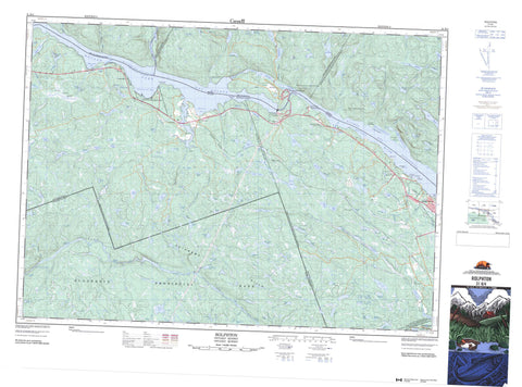
031K04 Rolphton Canada topo map, 1:50,000 scale
031K04 Rolphton NRCAN topographic map.
Includes UTM and GPS geographic coordinates (latitude and longitude). This 50k scale map is suitable for hiking, camping, and exploring, or you could frame it as a wall map.
Printed on-demand using high resolution, on heavy weight and acid free paper, or as an upgrade on a variety of synthetic materials.
Topos available on paper, Waterproof, Poly, or Tyvek. Usually shipping rolled, unless combined with other folded maps in one order.
- Product Number: NRCAN-031K04
- Parent Topo: TOPO-031K
- Map ID also known as: 031K04, 31K4, 31K04
- Unfolded Size: Approximately 26" high by 36" wide
- Weight (paper map): ca. 55 grams
- Map Type: POD NRCAN Topographic Map
- Map Scale: 1:50,000
- Geographical region: Ontario, Canada
Neighboring Maps:
All neighboring Canadian topo maps are available for sale online at 1:50,000 scale.
Purchase the smaller scale map covering this area: Topo-031K
Spatial coverage:
Topo map sheet 031K04 Rolphton covers the following places:
- Baie Cayien - Baie Colton - Baie de la Presqu'île d'en Bas - Baie de la Presqu'île d'en Haut - Baie Lower Presqu'île - Baie Upper Presqu'île - Driftwood Bay - Grants Creek Bay - Mackey Bay - Meilleurs Bay - Pichette Bay - Baird Point - Baird Point - Big Presqu'île - La Grande Presqu'île - La Petite Presqu'île - Little Presqu'île - Mackey Point - Marsh Lake Point - McFarlanes Point - Pine Point - Point Alexander - Point Stewart - Rocky Point - Stoney Point - Crooked Chute - Aberdeen - Aberford - Bronson - Edgar - Head - Malakoff - Nipissing - Rolph - Sainte-Anne - Stratton - Wylie - Adelard Lake - Bass Lake - Beaver Lake - Beerman Lake - Big Bass Lake - Chalkend Lake - Claret Lake - Clear Lake - Clouthier Lake - Colton Lake - Colton Lake - Conway Lake - Corry Lake - Coveo Lake - Demarco Lake - Devon Lake - Dow Lake - Duff Lake - Dunlop Lake - Dunns Lake - Eeyore Lake - Egan Lake - Emma Lake - Étang Allioni - Étang Ames - Étang des Geais Bleus - Findlay Lake - First Egan Lake - First James Lake - Freds Lake - Garreau Lake - Gunning Lake - Gunny Lake - Hammy Lake - Hanlan Lake - Harvey Lake - Head Lake - Heart Lake - Hogsback Lake - Holden Lake - Huey Lake - Iota Lake - James Lakes - Jennings Lake - Josies Lake - Kean Lake - Kellys Lake - Keon Lake - Keyes Lake - Lac à la Tortue - Lac Aberdeen - Lac Adanson - Lac Aiton - Lac Allioni - Lac Ames - Lac Andersson - Lac Belland - Lac Bite - Lac Bronson - Lac Clarke - Lac de la Théière - Lac de la Touche - Lac des Amis - Lac des Perdrix - Lac Desjardins - Lac du Buis - Lac du Busard - Lac du Condor - Lac du Filon - Lac du Pin Rouge - Lac Ferris - Lac Georges - Lac Holden - Lac Kennedy - Lac la Truite - Lac Lebeau - Lac Lernaut - Lac Lessing - Lac McConnell - Lac Mud - Lac Olin - Lac Penniseault - Lac Pinder - Lac Rock - Lac Roys - Lac Teapot - Lac Trout - Lac Turtle - Lac Vaseux - Lac Walls - Lac Welches - Lac Wyman - Lature Lake - Lazy Lake - Lee Lake - Little Bass Lake - Logslide Lake - Long Lake - Louie Lake - Lower Pergeon Lake - Manard Lake - Maraboo Lake - Margaret Lake - Marsh Lake - Marys Lake - McIntyre Lake - McKenna Lake - McSourley Lake - Menet Lake - Mill Lake - Moffat Lake - Moor Lake - Moore Lake - Moosehaunt Lake - Mossberry Lake - Nina Lake - Norman Lake - Notsolong Lake - Oliver Lake - Opaque Lake - Otter Lake - Otterson Lake - Oval Lake - Owl Lake - Park Lake - Parkline Lake - Patersons Lake - Perch Lake - Petit lac Pinceau - Petit lac Pinder - Pichette Lake - Pooh Lake - Powell Lake - Pregeon Lake - Rat Lake - Rock Lake - Rock Lake - Rondeau Lake - Roney Lake - Sand Lake - Second Egan Lake - Second James Lake - Shirley Lake - Sidetrack Lake - Sloan Lake - Smith Lake - Soldier Lake - Spencers Lake - Spur Lake - Sullivan Lake - Sweezy Lake - Tayler Lake - Tee Lake - Third Egan Lake - Third James Lake - Trout Lake - Twin Lakes - Upper Cartier Lake - Upper Pergeon Lake - Way Lake - West Dow Lake - Whitson Lake - Woods Lake - Wylie Lake - Young Lake - Base des Forces canadiennes Petawawa - Canadian Forces Base Petawawa - Champ de tir et champ de manoeuvre Petawawa - Petawawa Range and Training Area - Forêt refuge du Lac-à-la-Tortue - Petawawa Hills - Pontiac - Head, Clara and Maria - Rolph, Buchanan, Wylie and McKay - Algonquin Provincial Park - Driftwood Provincial Park - Grant's Creek Provincial Park - Réserve écologique André-Linteau - Réserve écologique de l'Aigle-à-Tête-Blanche - Réserve écologique James-Little - Zec Dumoine - Zec Saint-Patrice - Big Thompson Rapids - Five Mile Rapids - Grillade Rapids - Little Thompson Rapids - Rapides des Joachims - Rollway Rapids - Schooner Rapids - The Natch - Blue Beech Creek - Cartier Creek - Cayiens Creek - Chalk River - Clouthier Creek - Colton Creek - Conway Creek - Dow Creek - East Bruce Creek - Emma Creek - Findlay Creek - Grant Creek - Grants Creek - Harvey Creek - Heeney Creek - Heney Creek - Huey Creek - Jennings Creek - Kennedy Creek - Lafortune Creek - Lone Creek - Louie Creek - Mackey Creek - McConnell Creek - McSourley Creek - Moffat Creek - Moosehaunt Creek - Mossberry Creek - North Rouge Creek - Ottawa River - Petawawa River - Petite rivière à l'Ours - Pichette Creek - Powell Creek - Rivière à l'Ours - Rivière des Outaouais - Rivière des Outaouais - Rivière Dumoine - Rivière Ottawa - Rivière Saint-Cyr - Rondeau Creek - Roney Creek - Ruisseau Bill - Ruisseau Boom - Ruisseau Boom East - Ruisseau Boom West - Ruisseau Ferris - Ruisseau Latour - Ruisseau Marie-Jeanne - Ruisseau Mary-Jane - Ruisseau Penniseault - Ruisseau Pinceau - Tee Creek - Walkers Creek - Wylie Creek - Deep River - Laurentian Hills - Bass Lake - Fraser Landing - Mackey - Mackeys Station - Meilleurs Bay - Moor Lake - Moor Lake Station - Point Alexander - Rapides-des-Joachims - Rockcliffe - Rolphton - Stonecliff - Stonecliffe - Wylie - Grants Creek Marsh - Rapides-des-Joachims - Sheen-Esher-Aberdeen-et-Malakoff


