
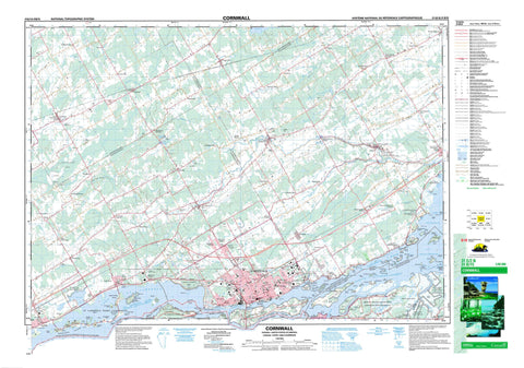
031G02 Cornwall Canada topo map, 1:50,000 scale
031G02 Cornwall NRCAN topographic map.
Includes UTM and GPS geographic coordinates (latitude and longitude). This 50k scale map is suitable for hiking, camping, and exploring, or you could frame it as a wall map.
Printed on-demand using high resolution, on heavy weight and acid free paper, or as an upgrade on a variety of synthetic materials.
Topos available on paper, Waterproof, Poly, or Tyvek. Usually shipping rolled, unless combined with other folded maps in one order.
- Product Number: NRCAN-031G02
- Parent Topo: TOPO-031G
- Map ID also known as: 031G02, 31G2, 31G02
- Unfolded Size: Approximately 26" high by 36" wide
- Weight (paper map): ca. 55 grams
- Map Type: POD NRCAN Topographic Map
- Map Scale: 1:50,000
- Geographical region: Ontario, Canada
Neighboring Maps:
All neighboring Canadian topo maps are available for sale online at 1:50,000 scale.
Purchase the smaller scale map covering this area: Topo-031G
Spatial coverage:
Topo map sheet 031G02 Cornwall covers the following places:
- Hoople Bay - Meadow Bay - Danis Point - Farlinger Point - Farlingers Point - Flanigans Point - Fraser Point - Glengarry Point - Graveyard Point - Long Sault Rapids Point - McGibbons Point - Pilons Point - Pointe Hopkins - Provast Point - Stonehouse Point - Windmill Point - Chenail Saint-Régis - Pollys Gut - Cornwall - Charlottenburgh - Cornwall - Dundee - Glengarry - Kenyon - Lancaster - Osnabruck - Roxborough - Stormont - Bourdon Drain - Charles Laplante Drain - Clarence Grant Drain - Cooper Drain - Donald McLennan Drain - Donald Smith Drain - Donihee Drain - Eastman Drain - Ferguson Drain - First Concession Drain - Fly Creek Drain - Glen Drain - Glen Falloch Drain - Glenroy Drain - Harland Drain - Henderson Drain - Joanette-Brunet Drain - John Coleman Drain - Leitch-McLennan Drain - McDermid-Richer Drain - McDonald Branch - McDonald Drain - McIntosh Drain - McLachlan Drain - McLaren-Montgomery Drain - McLellan-King Drain - McNaught Drain - Monkland Drain - Montgomery Drain - Murray Drain - Ninth Concession Drain - Oliver Magee Drain - Sam McIntosh Drain - Shaver Drain - Spring Creek Drain - Steele-Hough Drain - Wert Drain - Williamson Drain - Woods Drain - Akwesasne 59 - Akwesasne Indian Reserve 15 - Akwesasne Indian Reserve 59 - Réserve indienne Akwesasne 15 - Réserve indienne Akwesasne 59 - Réserve indienne St. Regis 15 - Réserve indienne St. Regis Akwesasne 59 - St. Regis Akwesasne Indian Reserve 59 - St. Regis Indian Reserve 15 - Bergin Island - Bredin Island - Camerons Crab - Centre Woodlands Island - Clark Island - Colquhoun Island - Colquhoun Island East - Colquhoun Island West - Colquhoun Islands - Cornwall Island - Dickinson Island - East Isle - East Woodlands Island - First Crab - First Crab - Fraser Crab - Fraser Island - Grape Island - Hamilton Island - Harvey Island - Heriot Island - Heriot Island - Hoople Island - Île aux Merises - Île Bass - Île Casistatie - Île Cattle - Île Châtelain - Île Christatie - Île Colquhoun Est - Île Colquhoun Ouest - Île Corn - Île Cow - Île Dickerson - Île Dodens - Île du Canal - Île Dundee - Île Goose - Île Hen - Île Jacobs - Île Jaune - Île Little Hog - Île Mud - Île Plum - Île Ronde - Île Saint-Régis - Île Simard - Île Stanley - Île Sugar Bush - Île Thompson - Îles Three Sisters - Îlet Grass - Jacobs Island - Little Colquhoun Island - Little Hog Island - Long Sault Island - Loon Island - Macdonell Island - Mille Roches Island - Mille Roches Island - Moulinette Island - Mulcaster Island - Osnabruck Island - Phillpotts Island - Pilon Island - Renshaw Island - Royal Baker Island - Saint-Régis Dyke - Second Crab - Sheek Island - Snetsinger Island - Squaw Island - St. Francis Island - Stanley Crab - Stanley Crab - Stanley Island - Stoneburner Island - Strachan Island - The Crabs - The Crabs - Third Crab - Third Crab - Vankoughnet Island - Wales Island - West Woodlands Island - Woodlands Island - Woodlands Islands - Lac Saint-François - Lac St-François - Lake St. Francis - Lake St. Lawrence - Loch Garry - Cornwall Canal - Lairds Hill - Macs Hill - Sandy Hill - Vinegar Hill - United Counties of Stormont, Dundas and Glengarry - Charlottenburgh - Cornwall - Finch - Kenyon - Lancaster - Lochiel - North Glengarry - North Stormont - Osnabruck - Roxborough - South Glengarry - South Stormont - Inverarden House National Historic Site of Canada - Lac Saint-François National Wildlife Area - Lieu historique national du Canada de la Maison-de-Sir-John-Johnson - Lieu historique national du Canada de la Maison-Inverarden - Réserve nationale de faune du lac Saint-François - Sir John Johnson House National Historic Site of Canada - Ontario - Quebec - Québec - Long Sault Rapids - Baudet River - Beaver Creek - Dixon Creek - Farlinger Branch - Ferguson Branch - Finney Creek - Fleuve Saint-Laurent - Fraser Creek - Grays Creek - Hoople Creek - Le Bateau - Lefebvre Branch - McIntyre Creek - Moose Creek - North Raisin River - Palen Creek - Pattingale Creek - Payne River - Raisin River - Rivière au Baudet - Rivière aux Saumons - Rivière Beaudette - Rivière Payne - Rivière Saint-Régis - Ruisseau Bittern - Ruisseau Pike - Shaver Creek - South Raisin River - St. Lawrence River - St. Lawrence River - Stoney Creek - Sutherland Creek - Wereley Creek - Werely Creek - Westleys Creek - Pont du Bateau - Crab Island Shoal - Delany Shoal - Highlander Shoal - Apple Hill - Avondale - Avonmore - Black River - Bonville - Brown House Corner - Camerons Point - Caribou Cameron - Cashionglen - Cashions Glen - Churchill Heights - Cornwall Centre - Cornwall Island - Cornwall Junction - Dickinson Landing - Dickinsons Landing - Dixon - Dover Heights - Dundee - Eamers Corners - Glen Donald - Glen Falloch - Glen Gordon - Glen Gordon Station - Glen Walter - Glenbrook - Glenbrook Station - Glendale - Glendale - Glenroy - Glenroy Station - Glenview Heights - Grants Corners - Gravel Hill - Harrison Station - Harrisons Corners - Ingleside - Lakeview Heights - Lancaster - L'Île-Saint-Régis - Long Sault - Lunenburg - MacGillivray Bridge - MacGillivrays Bridge - Maple Grove - Martintown - McMillan Corners - McMillans Corners - Mille Roches - Monckland Station - Monkland - Moulinette - Munroe Mills - Munroes Mills - North Branch - North Lancaster - North Lunenburg - Northfield - Northfield Station - Pine Hill - Riverdale - Rosedale Terrace - Saint-Régis - Sandfield Mills - St. Andrews - St. Andrews West - St. Raphael West - St. Raphaels - Strathmore - Summerstown - Summerstown Station - Tolmies Corners - Tyotown - Uscan - Wales - Warina - Williamstown - Marais de la Ferme Therrien - Marais Sugar Bush - Mud Lake Swamp - Newington Bog - Dundee - Mille-Roches


