
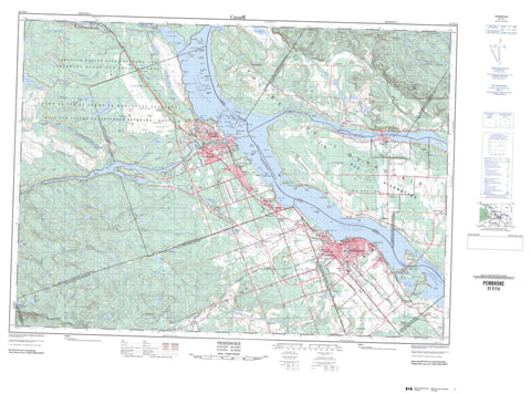
031F14 Pembroke Canada topo map, 1:50,000 scale
031F14 Pembroke NRCAN topographic map.
Includes UTM and GPS geographic coordinates (latitude and longitude). This 50k scale map is suitable for hiking, camping, and exploring, or you could frame it as a wall map.
Printed on-demand using high resolution, on heavy weight and acid free paper, or as an upgrade on a variety of synthetic materials.
Topos available on paper, Waterproof, Poly, or Tyvek. Usually shipping rolled, unless combined with other folded maps in one order.
- Product Number: NRCAN-031F14
- Parent Topo: TOPO-031F
- Map ID also known as: 031F14, 31F14
- Unfolded Size: Approximately 26" high by 36" wide
- Weight (paper map): ca. 55 grams
- Map Type: POD NRCAN Topographic Map
- Map Scale: 1:50,000
- Geographical region: Ontario, Canada
Neighboring Maps:
All neighboring Canadian topo maps are available for sale online at 1:50,000 scale.
Purchase the smaller scale map covering this area: Topo-031F
Spatial coverage:
Topo map sheet 031F14 Pembroke covers the following places:
- Baie de Chichester - Baie des Roy - Baie Harrington - Baie Meehan - Baie O'Brien - Baie Winters - Black Bay - Black Bay - Burnt Bridge Bay - Chalk Bay - Hazley Bay - Lamure Bay - MacGregor Bay - Antler Point - Black Point - Clement Point - Gust Point - Indian Point - King Point - Petawawa Point - Pointe de Chichester - Pointe Indian - Pointe Kelley - Pointe Kelly - Pointe Kennedy - Pointe Landen - Pointe Leblanc - Pointe Mackey - Pointe Murphy - Sullivan Point - The Head of the Island - Wegner Point - Chenal de la Culbute - Chenal Leblanc - Chenal Lost - Lost Channel - Lower Narrows - Passe Lower - Upper Narrows - Pembroke - Alice - Buchanan - Chichester - Fraser - Île-aux-Allumettes - Île-des-Allumettes - McKay - Nipissing - Pembroke - Petawawa - Richards - Saint-Alphonsus - Saint-Joseph - Saint-Paul-the-Hermit - Sheen - Waltham - Westmeath - Wylie - Basil Island - Beacon Island - Beckett Island - Carl Island - Chapman Island - Christie Island - Corinne Island - Cornelius Island - Cotnam Island - Crab Islands - Cushing Island - Daisy Island - Davis Island - Demers Island - Dow Island - Dunlop Island - Ellis Island - Evelyn Island - Fish Island - Forks Island - Fraser Island - Gibraltar Island - Green Island - Gutzman Island - Hazel Island - Houston Island - Île aux Allumettes - Île Berry - Île D'Arcy - Île Gagnon - Île Hawley - Île Henry - Île John-Park - Île Leblanc - Île Lorelei - Île Morrison - Irving Island - Jamieson Island - John Joe Island - King Edward Island - Lillian Island - Louise Island - Mackie Island - Metcalf Island - Metcalfe Island - Oak Island - O'Meara Island - Pearl Island - Pink Island - Poker Island - Princess Island - Ramsey Island - Randolph Island - Riddell Island - Ruby Islet - Sack's Island - Shoal Island - Short Turn Island - Spug Island - Steamer Island - Wabewawa Island - Willson Island - Windsor Island - Allumette Lake - Antler Lake - Barr Lake - Beaver Pond - Big Lake - Big Trout Lake - Bostwick Lake - Brennan Lake - Carson Lake - Centre Lake - Charlebois Lake - Clement Lake - Colby Lake - Corr Lake - Corry Lake - Duke Lake - East Bear Lake - Flat Iron Lake - Goltz Lake - Halfmile Lake - Johnny Lake - Jorgens Lake - Lac aux Allumettes - Lac Cobb - Lac Dennie - Lac Donay - Lac Downey - Lac du Bois Dur - Lac du Calumet - Lac Étroit - Lac Halfway - Lac Hurdman - Lac Isabel - Lac Manners - Lac Manny - Lac McDonald - Lac Poupore - Lac Ranger - Lac Turner - Lac Venne - Lemke Lake - Long Lake - Lower Allumette Lake - Mackenzie Lake - Mason Lake - Maunsell Lake - Maves Lake - Meitz Lake - Mill Lake - Mudturtle Lake - Percy Lake - Prange Lake - Range Lake - Rutherford Lake - Sand Lake - Sturgeon Lake - Summers Lake - Supple Lake - Thomas Lake - Tucker Lake - Unit Lake - Wolf Lake - Paquette Landing - Base des Forces canadiennes Petawawa - Canadian Forces Base Petawawa - Champ de tir et champ de manoeuvre Petawawa - Petawawa Range and Training Area - Holy Spirit - Our Lady of the Lake - Beacon Hill - Clement Hill - Coteau à Butler - Gust Hill - Jorgens Hill - MacGregor Hill - Mont Dubé - Pranges Hills - Radtke Hill - Signal Hill - Spring Hill - The Three Hills - Touseants Hill - Pontiac - Renfrew - Alice and Fraser - Hagarty and Richards - Killaloe, Hagarty and Richards - Laurentian Valley - Pembroke - Rolph, Buchanan, Wylie and McKay - Ross - Stafford - Stafford and Pembroke - Westmeath - Whitewater Region - Algonquin Provincial Park - Barron River Provincial Park - Petawawa Terrace Provincial Park - Drury Plain - Duke Plain - Gust Plain - Jorgens Plain - Plaines de Chapeau - The Plains - Ontario - Big Eddy Rapids - Halfmile Rapids - Race Horse Rapids - Rapides de la Culbute - Rapides de l'Islet - Rapides des Allumettes - Rapides du Chapeau - White Horse Rapids - Antler Creek - Barron River - Black Bay Creek - Blackduck Creek - Centre Creek - Chalk River - Charlebois Creek - Clement Creek - Crooked Lake Creek - Culbute Channel - Duke Creek - Hales Creek - Halfmile Creek - Hennessys Creek - Indian River - Jorgens Creek - Landry Creek - Locksley Creek - Maunsell Creek - Maves Creek - McKay Creek - Mill Creek - Moffats Canal - Muskrat River - O'Mearas Creek - Ottawa River - Petawawa River - Range Creek - Rivière des Outaouais - Rivière des Outaouais - Ruisseau Calumet - Ruisseau de la Culbute - Ruisseau Houde - Ruisseau Kennedy - Ruisseau Lapierre - Ruisseau Loyola-Ryan - Ruisseau Nicabong - Ruisseau Nichabau - Ruisseau O'Brien - Ruisseau Phelan - Ruisseau Poupore - Ruisseau Sallafranque - Rutherford Creek - Spug Creek - Summers Creek - Tucker Creek - Unit Creek - Young Creek - Côte de l'Église - Côte du Marais - Chapeau - Laurentian Hills - Petawawa - Alice - Allumette - Baelstadt - Behnke Wood - Black Bay - Brindle Crossing - Brumsfield - Cedar Beach - Chapeau - Chapeau - Chartrands - Coin-chez-Leblanc - Cotnam Island - Davis Mills - Demers - Demers-Centre - Desjardinsville - Duke Crossing - Fairview - Forest Lea - Fort William - Government Road - Greenwood - Hamiltonsfield - Hampelsfield - Hiam - Hoffman - Indian - Indian Landing - Jorgens - Kathmae - Kathmae Siding - Kramer - Kramer Subdivision - La Tête-de-l'Île - Landry Crossing - Laurentian View - Le Flat - Le Landing - Marion's Corner - McGuire - Midway Crossing - Montgomery Crossing - Nicabong - Nichabau - Old Road Crossing - Pembroke Junction - Petawawa - Petawawa Point - Pine Meadows - Pine Ridge - Pleasant View - Race Horse Camp - Riverview - Saint-Joseph - Shady Nook - Sheenboro - Sheenboro - Stafford - Stewart Crossing - Stewart Farm - Stonebrook - Wabash - River Bottom - Vallée de l'Outaouais - Chichester - L'Isle-aux-Allumettes - L'Isle-aux-Allumettes - L'Isle-aux-Allumettes-Partie-Est - Sheenboro - Sheen-Esher-Aberdeen-et-Malakoff - Waltham - Waltham-et-Bryson


