
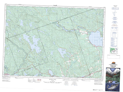
031F12 Round Lake Canada topo map, 1:50,000 scale
031F12 Round Lake NRCAN topographic map.
Includes UTM and GPS geographic coordinates (latitude and longitude). This 50k scale map is suitable for hiking, camping, and exploring, or you could frame it as a wall map.
Printed on-demand using high resolution, on heavy weight and acid free paper, or as an upgrade on a variety of synthetic materials.
Topos available on paper, Waterproof, Poly, or Tyvek. Usually shipping rolled, unless combined with other folded maps in one order.
- Product Number: NRCAN-031F12
- Parent Topo: TOPO-031F
- Map ID also known as: 031F12, 31F12
- Unfolded Size: Approximately 26" high by 36" wide
- Weight (paper map): ca. 55 grams
- Map Type: POD NRCAN Topographic Map
- Map Scale: 1:50,000
- Geographical region: Ontario, Canada
Neighboring Maps:
All neighboring Canadian topo maps are available for sale online at 1:50,000 scale.
Purchase the smaller scale map covering this area: Topo-031F
Spatial coverage:
Topo map sheet 031F12 Round Lake covers the following places:
- Bell Bay - Bells Bay - Bonnechere Bay - Burnt Depot Bay - Burnt Shanty Bay - Dennisons Bay - Dunne's Bay - Enos Bay - Little Cub Bay - Reynolds Bay - Rorys Bay - Smiths Bay - St. Patricks Bay - White Mountain Bay - Black Point - Long Point - Gaudreaus Narrows - Greenwoods Narrows - Thomas Narrows - White Mountain Narrows - High Falls - Jenkins Chute - Mountain Chute - Burns - Clancy - Dickens - Guthrie - Hagarty - Jones - Lyell - Master - Murchison - Nipissing - Richards - Sherwood - Big Green Island - Burnt Island - Cherry Island - Crab Island - Edwards Island - Idylwild Island - Little Green Island - McGuires Island - Pine Island - Sleigh Island - Tight Little Island - Turkey Island - Victoria Island - Achillea Lake - Acorn Lake - Albert Lake - Alsever Lake - Arabis Lake - Argue Lake - Aylen Lake - Baldwins Lake - Balfour Lake - Bark Lake - Basin Lake - Bear Lake - Bear Lake - Beaverdam Lake - Beechnut Lake - Begonia Lake - Big Cranberry Lake - Billings Lake - Breezy Lake - Brule Lake - Burnetts Pond - Burns Lake - Carson Lake - Chapeskis Lake - Clancy Lake - Cloudy Lake - Cloverleaf Lake - Couchain Lake - Couchain Lakes - Couchain Lakes - Couchain Lakes - Couchain Lakes - Cranberry Lake - Creepy Lake - Curriers Lake - Cybulski Lake - Deacon Lake - Dickens Long Lake - Divazie Lake - Dodge Lake - Drohans Ponds - Duck Lake - Finger Lake - Fish Lake - Gun Lake - Haskins Lake - Hoist Lake - Island Lake - Jack Lakes - Jacks Lake - Jacks Lakes - Jenkins Lake - Jocko Lake - Johns Lake - Kretzel Lake - Lafleur Lake - Laycocks Lake - Little Carson Lake - Little Cranberry Lake - Little Cub Lake - Little Hogan Lake - Little Pike Lake - Little Round Lake - Lough Garvey - Lower Pine Lake - Lupine Lake - Martineau Lake - McDonald Lake - McDonalds Pond - McGuire Lake - McKenzie Pond - McLachlin Lake - McNevin Lake - Mick Lake - Minkspaw Lake - Minnow Lake - Mishap Lake - Monkshood Lake - Moose Lake - Mountain Lake - Mugho Lake - Murphys Lake - Nipren Lake - O'Neill Lake - Oram Lake - Otter Lake - Parissien Lake - Paugh Lake - Pergeon Lake - Pike Lake - Pine Lake - Rabbit Lake - Rabbittail Lake - Redpine Lake - Rich Lake - Robitaille Lake - Rocko Lake - Rorys Lake - Round Lake - Roundbush Lake - Ruddy Lake - Ruddys Lake - Salvia Lake - Sam Lake - Sams Lake - Speckled Lake - Spectacle Lakes - Spruce Lake - Spruce Pond - St. Patricks Lake - Stevenson Lake - Stringers Lake - Stubbs Lake - Sullivan Lake - Supply Lake - Surprise Lake - Sweaks Pond - Trout Lake - Turners Lake - Upper Pine Lake - Victoria Lake - Vireo Lake - Walker Lake - Wilkins Lake - Wolfsden Lake - Woodsher Lake - Yantha Lake - Angelo Hill - Billings Hill - Buck Hill - Burnetts Mountain - Fish Lake Mountain - Flat Top Hill - Fox Hill - Gariepy Mountains - Gun Lake Mountain - Keetch's Mountain - Kluke Lookout - Lost Hill - Madawaska Highlands - Oak Hill - Opeongo Knob - Paint Hill - Pauls Hill - Shrine Hill - Squaw Rock - Twin Matthews Hills - White Mountain - Wilno Hills - Airy - Hagarty and Richards - Killaloe, Hagarty and Richards - Madawaska Valley - Radcliffe - Sherwood, Jones and Burns - South Algonquin - Algonquin Provincial Park - Bell Bay Provincial Park - Bonnechere Provincial Park - Bonnechere River Provincial Park - Carson Lake Provincial Park - Foy Property Provincial Park - Opeongo River Provincial Park - Upper Madawaska River Provincial Park - Jacks Chute Rapids - Priests Rapids - Stacks Rapids - Aylen River - Basin Creek - Bonnechere River - Byers Creek - Clancy Creek - Dupuis Creek - Hogan Creek - Jack Creek - Jacks Creek - Little Cranberry Creek - Madawaska River - McNevin Creek - Opeongo River - Paugh Creek - Pine River - Rabbittail Creek - Reserve Creek - Richards Creek - Robitaille Creek - Sherwood River - Turner Creek - Turners Creek - Wilkins Creek - Zummachs Creek - McGuirl Rock - Aylen Lake - Aylen Lake Station - Bark Lake - Basin Depot - Bonnechere - Madawaska - Opeongo - Paugh Lake - Round Lake Centre - Simpsons - Wilno - Wilno Pass - Aylen Marsh - Bear Marsh - Brimers Marsh - Burnetts Marsh - Dennisons Marsh - Gun Lake Marsh - Peters Marsh - Sherwood Marsh


