
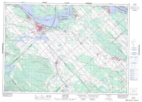
031F08 Arnprior Canada topo map, 1:50,000 scale
031F08 Arnprior NRCAN topographic map.
Includes UTM and GPS geographic coordinates (latitude and longitude). This 50k scale map is suitable for hiking, camping, and exploring, or you could frame it as a wall map.
Printed on-demand using high resolution, on heavy weight and acid free paper, or as an upgrade on a variety of synthetic materials.
Topos available on paper, Waterproof, Poly, or Tyvek. Usually shipping rolled, unless combined with other folded maps in one order.
- Product Number: NRCAN-031F08
- Parent Topo: TOPO-031F
- Map ID also known as: 031F08, 31F8, 31F08
- Unfolded Size: Approximately 26" high by 36" wide
- Weight (paper map): ca. 55 grams
- Map Type: POD NRCAN Topographic Map
- Map Scale: 1:50,000
- Geographical region: Ontario, Canada
Neighboring Maps:
All neighboring Canadian topo maps are available for sale online at 1:50,000 scale.
Purchase the smaller scale map covering this area: Topo-031F
Spatial coverage:
Topo map sheet 031F08 Arnprior covers the following places:
- Baie Black - Baie du Camp - Baie du Chat - Baie Kilroy - Baie Pontiac - Bane Bay - Buckham Bay - Buckham's Bay - Constance Bay - Goodwins Bay - Hayes Bay - Horseshoe Bay - Lavergne Bay - Le Bas-Fond - Marshall Bay - Pickerel Bay - Pocket Bay - Rhoddys Bay - Roddys Bay - Three Mile Bay - Indian Point - Lavergne Point - Norway Point - Pointe aux Roches - Pointe Hudson - Pointe Indienne - Pointe Julius - Pointe Mohr - Pointe Ross - Rafting Point - Rhoddys Point - Stony Point - Le Vieux Canal - Ottawa - Chute Conroy - Chute O'Connor - The Burnt Lands - Bristol - Darling - Eardley - Fitzroy - Huntley - Lanark - March - McNab - National Capital Region - National Capital Region - Onslow - Pakenham - Ramsay - Région de la Capitale nationale - Région de la Capitale nationale - Renfrew - Torbolton - Barrage de la Chute-des-Chats - Barrage des Chats - Centrale de la Chute-des-Chats - La Barrière - Le Carcajou - Alexandra Island - Barber Island - Beaver Island - Crane Island - Grierson Island - Île Allen - Île du Centre - Île Greene - Île Mulligan - Île O'Connor - Île Twelve Mile - Kedey's Island - Killaly Island - Laflamme Island - Little Birch Island - Morris Island - Slide Island - Snake Island - Victoria Island - Casey Lake - Lac à Farr - Lac des Chats - Lac des Chats - Lake Madawaska - Lowney Lake - Petit lac à la Mine d'Or - White Lake - Willis Lake - Baskin Wharf - Poste de la Chute-des-Chats - Boomcamp Hill - Haveys Hill - Indian Hill - Pakenham Mountains - The Sand Hills - White Lake Mountain - Carleton - Lanark - Les Collines-de-l'Outaouais - Ottawa-Carleton - Pontiac - Renfrew - Darling - Fitzroy - Goulbourn - Huntley - Lanark - Lanark Highlands - Lavant, Dalhousie and North Sherbrooke - Marlborough - McNab - McNab/Braeside - North Gower - North West Lanark - Osgoode - Pakenham - Ramsay - Rideau - Torbolton - West Carleton - Alexander Stewart Provincial Park - Burnt Lands Provincial Park - Fitzroy Provincial Park - White Lake Conservation Reserve - Ontario - Blakeney Rapids - Chute Mohr - Flat Rapids - Rapides des Chats - Ross Rapids - Campbell Creek - Carp River - Cartwrights Creek - Cody Creek - Constance Creek - Dochart Creek - Forsyth Creek - Forsythe Creek - Glen Creek - Hansons Creek - Haydons Creek - Indian Creek - Indian River - Madawaska River - Mississippi River - Mississippi River Snye - Ottawa River - Ottawa River South Branch - Rivière des Outaouais - Rivière des Outaouais - Rivière Ottawa - Ruisseau Belisle - Ryan Creek - Stanley Creek - The Canal - Waba Creek - Constance Shoal - Arnprior - Mississippi Mills - Quyon - Antrim - Armitage - Baskin's Beach - Bennies Corners - Blakeney - Braeside - Bristol Mines - Bristol-les-Mines - Buckham Bay - Buckham's Bay - Carp - Cedar Hill - Chats Haven - Clay Bank - Clay Valley - Constance Bay - Corkery - Dewars - Dirleton - Dochart - Dunrobin - Elm - Fitzroy - Fitzroy Harbour - Galetta - Greenlands - Kilmaurs - Kinburn - Kingdon Mine - Knox Landing - Malwood - Manion Corners - Mansfield - Marathon - Marathon Village - Marshall Bay - Mohr Corners - Pakenham - Panmure - Pinegrove - Plage-Albert-Tremblay - Plage-Bélisle - Plage-de-la-Pointe-Indienne - Plage-Julius-Point - Plage-Léo-Allen - Plage-Philippe-Allen - Plage-Pierre-Tremblay - Plage-Pontiac - Pontiac - Pontiac Station - Robertson Corners - Sand Point - Sandy Beach - Sandy Hook - Snedden - Stewartville - Uneeda - Vydon Acres - Waba - Westwood - White - White Lake - Woodlawn - Blackberry Meadow - Bristol - Bristol - Eardley - Onslow - Pontiac


