
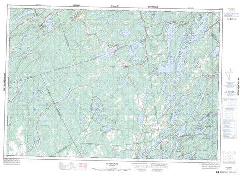
031C10 Tichborne Canada topo map, 1:50,000 scale
031C10 Tichborne NRCAN topographic map.
Includes UTM and GPS geographic coordinates (latitude and longitude). This 50k scale map is suitable for hiking, camping, and exploring, or you could frame it as a wall map.
Printed on-demand using high resolution, on heavy weight and acid free paper, or as an upgrade on a variety of synthetic materials.
Topos available on paper, Waterproof, Poly, or Tyvek. Usually shipping rolled, unless combined with other folded maps in one order.
- Product Number: NRCAN-031C10
- Parent Topo: TOPO-031C
- Map ID also known as: 031C10, 31C10
- Unfolded Size: Approximately 26" high by 36" wide
- Weight (paper map): ca. 55 grams
- Map Type: POD NRCAN Topographic Map
- Map Scale: 1:50,000
- Geographical region: Ontario, Canada
Neighboring Maps:
All neighboring Canadian topo maps are available for sale online at 1:50,000 scale.
Purchase the smaller scale map covering this area: Topo-031C
Spatial coverage:
Topo map sheet 031C10 Tichborne covers the following places:
- Buck Bay - Crow Bay - Green Bay - Hawley Bay - Hollywood Bay - Long Bay - McCrimmon Bay - Mill Bay - Mire Bay - Mud Bay - Post Office Bay - Elm Point - Whiskey Point - Bedford - Camden East - Frontenac - Hinchinbrooke - Kennebec - Lanark - Leeds - Lennox and Addington - Loughborough - North Crosby - Olden - Oso - Portland - Sheffield - South Sherbrooke - Storrington - Ashnelot Island - Barrs Island - Bear Island - Birch Island - Birch Island - Bird Island - Buck Island - Cedar Island - Channel Island - Chicken Island - Comet Island - Earincliffe Island - Florence Island - Grape Island - Horseshoe Island - Loon Island - Mica Island - Michaels Island - Pine Island - Poplar Island - Powells Island - Rase Island - Strawberry Island - Timmermans Island - Twin Islands - Abbott Lake - Arab Lake - Arden Lake - Arkon Lake - Atwood Lake - Barrett Pond - Barretts Pond - Barton Lake - Bass Lake - Bass Lake - Basshook Lake - Bear Lake - Beaver Lake - Big Clear Lake - Big Marl Lake - Big McNeil Lake - Big Salmon Lake - Big Sunfish Lake - Birch Lake - Bitch Lake - Black Lake - Bobs Lake - Buck Lake - Bull Lake - Burns Pond - Burridge Lake - Butterill Lake - Canoe Lake - Carnahan Lake - Carroll Lake - Cedar Lake - Cedar Lake - Chippego Lake - Clear Lake - Clearwater Lake - Cloudy Lake - Clow Lake - Cole Lake - Cook Lake - Cranberry Lake - Cranberry Lake - Crooks Creek Lake - Crotch Lake - Crow Lake - Danby Lake - Desert Lake - Devil Lake - Doe Lake - Dog Lake - Doran Lake - Duncan Lake - Dutch Lake - Eagle Lake - East McNeil Lakes - East McNeil Lakes - Echo Lake - Eel Lake - Elbow Lake - Farrell Lake - Farren Lake - Fermoy Lake - Fifth Depot Lake - First Depot Lake - Fish Lake - Folsom Lake - Fourteen Island Lake - Fourth Depot Lake - Fraser Lake - Garrison Lake - Garter Lake - Green Lake - Gull Lake - Hemlock Lake - Herring Lake - Holleford Lake - Horseshoe Lake - Howes Lake - Jeffs Lake - Judy Pond - Kellar Lake - Kennebec Lake - Kingsford Lake - Leggat Lake - Little Bear Lake - Little Beaver Lake - Little Black Lake - Little Canoe Lake - Little Clear Lake - Little Gull Lake - Little John Lake - Little Marl Lake - Little McNeil Lake - Little Mud Lake - Little Mud Lake - Little Norway Lake - Little Rock Lake - Little Salmon Lake - Little Sunfish Lake - Long Lake - Long Pond Lake - Loon Lake - Loyst Lake - Lyman Lake - Lynch Lake - Lynn Lake - McGuire Lake - McLaughlin Lake - McLeans Lake - McNeil Lakes - McNeil Mud Lake - Meadow Lake - Miller Lake - Miner Lake - Mink Lake - Moulton Lake - Murphy Lake - North Otter Lake - Norway Lake - Norway Lake - Norway Mud Lake - Oconto Lake - O'Reilly Lake - Otter Lake - Otter Lake - Paddys Lake - Pleasant Lake - Pond Lily Lake - Potspoon Lake - Puddle Lake - Puzzle Lake - Reynoldston Lake - Rothwell Lake - Salmon Lake - Salmon Lake - Sand Lake - Sangster Lake - Scanlin Lake - Second Depot Lake - Sexsmith Lake - Sharbot Lake - Sheffield Long Lake - Sigsworth Lake - Sixth Depot Lake - Skewgaw Lake - Slave Lake - Small Clear Lake - South Cranberry Lake - South Otter Lake - Spruce Lake - St. Andrew Lakes - St. George Lake - Stevenson Lake - Sucker Lake - Tetsmine Lake - Third Depot Lake - Thirteen Island Lake - Thirty Island Lake - Thompson Lake - Thompson Pond - Victoria Lake - Wallbridge Lake - Watson Lake - Weatherhead Lake - West Cranberry Lake - West Lake - West Norway Lake - Wheeler Lake - White Lake - Wolfe Lake - Yankee Lake - Youngs Mill Pond - Abbotts Hill - Arney Mountain - Barrs Hill - Church Hill - Railway Hill - The Mountain - Frontenac - Lanark - Lennox and Addington - United Counties of Leeds and Grenville - Bastard and South Burgess - Bathurst - Bathurst Burgess Sherbrooke - Bedford - Camden East - Central Frontenac - Hinchinbrooke - Kennebec - Loughborough - North Burgess - North Crosby - Olden - Oso - Portland - Rideau Lakes - Sheffield - South Crosby - South Elmsley - South Frontenac - South Sherbrooke - Stone Mills - Storrington - Tay Valley - Depot Lakes Conservation Area - Frontenac Provincial Park - Mellon Lake Conservation Reserve - Puzzle Lake Provincial Park - Barrs Creek - Beaver Creek - Carman Creek - Cole Creek - Davern Creek - Depot Creek - Devil Lake Creek - Eagle Creek - Fish Creek - Mitchell Creek - Otter Creek - Salmon River - Shibagau Creek - Stag Creek - Story Creek - Stub Creek - Sucker Harbour Creek - Uens Creek - White Creek - Whitman Creek - Arden - Ardendale - Bedford - Bellheck - Bobs Lake - Bradshaw - Burridge - Camp Oconto - Cole Lake - Crow Lake - Desert Lake - Echo - Fermoy - Glendower - Godfrey - Gull Creek - Hinchinbrooke - Long Lake - McLean - Mountain Grove - Oak Flats - Oconto - Olden - Parham - Piccadilly - Reynoldston - Sangster - Tichborne - Trafford - Wagarville - Wilkinson - Vandusens Marsh


