
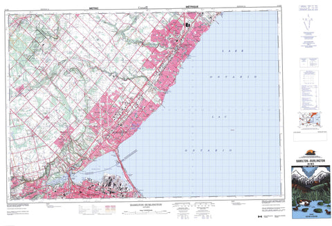
030M05 Hamilton Burlington Canada topo map, 1:50,000 scale
030M05 Hamilton Burlington NRCAN topographic map.
Includes UTM and GPS geographic coordinates (latitude and longitude). This 50k scale map is suitable for hiking, camping, and exploring, or you could frame it as a wall map.
Printed on-demand using high resolution, on heavy weight and acid free paper, or as an upgrade on a variety of synthetic materials.
Topos available on paper, Waterproof, Poly, or Tyvek. Usually shipping rolled, unless combined with other folded maps in one order.
- Product Number: NRCAN-030M05
- Parent Topo: TOPO-030M
- Map ID also known as: 030M05, 30M5, 30M05
- Unfolded Size: Approximately 26" high by 36" wide
- Weight (paper map): ca. 55 grams
- Map Type: POD NRCAN Topographic Map
- Map Scale: 1:50,000
- Geographical region: Ontario, Canada
Neighboring Maps:
All neighboring Canadian topo maps are available for sale online at 1:50,000 scale.
Purchase the smaller scale map covering this area: Topo-030M
Spatial coverage:
Topo map sheet 030M05 Hamilton Burlington covers the following places:
- Bronte Harbour - Burlington Bay - Hamilton Harbour - Lottridge Inlet - McCassa Bay - Oakville Harbour - Oggs Inlet - Stipes Inlet - Willow Cove - Windermere Basin - Burlington Beach - Hamilton Beach - Van Wagners Beach - Bull's Point - Carrolls Point - Indian Point - Kingfisher Point - Princess Point - Rattlesnake Point - Sassafras Point - Willow Point - Burlington - Hamilton - Mississauga - Milton Heights - Niagara Escarpment - Borer's Falls - Tews Falls - Websters Falls - Ancaster - Barton - East Flamborough - Halton - Nelson - Trafalgar - Wentworth - West Flamborough - Cockpit Island - Hickory Island - Rat Island - Campbellville Pond - Carlisle Pond - Crawford Lake - Fisher's Pond - Lac Ontario - Lake Medad - Lake Ontario - McClures Lake - Progreston Pond - West Pond - Burlington Canal - Desjardins Canal - Burlington Heights - Calcium Pits - Mount Nemo - Halton - Hamilton-Wentworth - Peel - Wentworth - Ancaster - Beverly - Binbrook - East Flamborough - East Flamborough - Glanbrook - Glanford - Nelson - Trafalgar - West Flamborough - West Flamborough - Bronte Creek Provincial Park - Crawford Lake Conservation Area - Crooks Hollow Conservation Area - HMCS Haida National Historic Site of Canada - Kelso Conservation Area - Lieu historique national du Canada du N. C. S. M. Haida - Rattlesnake Point Conservation Area - Spencer Gorge / Webster's Falls Conservation Area - Ancaster Creek - Appleby Creek - Avonhead Creek - Avonhead Creek - Borer's Creek - Bronte Creek - Clearview Creek - Coldwater Creek - East Sixteen Mile Creek - East Spencer Creek - Falcon Creek - Fourteen Mile Creek - Grindstone Creek - Hager Creek - Hopkins Creek - Indian Creek - Joshua Creek - Joshuas Creek - Joshua's Creek - Lakeside Creek - Limestone Creek - Logie's Creek - McCraney Creek - Morrison Creek - Munn's Creek - Oakville Creek - Osenego Creek - Rambo Creek - Rambro Creek - Redhill Creek - Rock Chapel Creek - Roseland Creek - Shannon's Creek - Sheldon Creek - Shore Acres Creek - Shoreacres Creek - Sixteen Mile Creek - Spencer Creek - Spring Creek - Sulphur Creek - Sydenham Creek - Tuck Creek - Wedgewood Creek - Randle Reef - Milton - Oakville - Ainslie Wood - Ainslie Wood East - Ainslie Wood North - Ainslie Wood West - Aldershot - Alton - Ancaster - Appleby - Ash - Bayview - Beasley - Blacks Corners - Boyne - Braeheid Survey - Brant Hills - Bridgeview Survey - Brock Gardens - Bronte - Bronte Station - Bullocks Corners - Burlington Beach - Campbellville - Carlisle - Castle Green - Cedar Springs - Central - Charnwood - Chedoke Park - Clappisons Corners - Clappison's Corners - Clarksdale - Clearview - Cootes Paradise - Corktown - Crown Point East - Crown Point West - Dundas - Dundurn - Durand - Dynes - East Lake - Elizabeth Gardens - Ennisclare Park - Falgarwood - Flamboro - Flamboro - Flamboro Centre - Flamboro Station - Flamborough - Freeman - Ghent - Gibson - Glenorchy - Glenwood Heights - Glenwood Park - Greensville - Guelph Junction - Hamilton - Hamilton Beach - Harper Corners - Highland Park Survey - Highview Survey - Holton Heights - Hopkins Corners - Hopkins Court - Hopkins Survey - Indian Point - Iroquois Ridge - Kent Gardens - Kilbride - Kirkendall North - Kirkendall South - La Salle - Lakeside - Landsdale - Longacres - Longmoor - Lowville - Maple - McDonald Court - Merton - Mill Grove - Mill Grove Station - Millgrove - Millgrove Station - Mount Nemo - Mountain Gardens - Mountainview - Nelson - North End - North End East - North End West - Orchard - Palermo - Palmer - Parkview East - Parkview West - Pleasant Valley - Pleasant View Survey - Port Nelson - Progreston - Queensway - Rock Chapel - Rockcliffe Survey - Roseland - Shoreacres - Stinson - Stipeley - Strathcona - Strathcona Gardens - Sunningdale - Tansley - Thayendanegea - Trafalgar - Tyandaga - University Gardens - Waterdown - Waterdown North - Wellington - Westdale - Westdale North - Westdale South - Zimmerman - Crook's Hollow - Dundas Valley - Hidden Valley - Medad Valley - Nassagaweya Canyon - Cootes Paradise


