
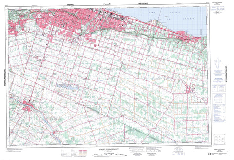
030M04 Hamilton Grimsby Canada topo map, 1:50,000 scale
030M04 Hamilton Grimsby NRCAN topographic map.
Includes UTM and GPS geographic coordinates (latitude and longitude). This 50k scale map is suitable for hiking, camping, and exploring, or you could frame it as a wall map.
Printed on-demand using high resolution, on heavy weight and acid free paper, or as an upgrade on a variety of synthetic materials.
Topos available on paper, Waterproof, Poly, or Tyvek. Usually shipping rolled, unless combined with other folded maps in one order.
- Product Number: NRCAN-030M04
- Parent Topo: TOPO-030M
- Map ID also known as: 030M04, 30M4, 30M04
- Unfolded Size: Approximately 26" high by 36" wide
- Weight (paper map): ca. 55 grams
- Map Type: POD NRCAN Topographic Map
- Map Scale: 1:50,000
- Geographical region: Ontario, Canada
Neighboring Maps:
All neighboring Canadian topo maps are available for sale online at 1:50,000 scale.
Purchase the smaller scale map covering this area: Topo-030M
Spatial coverage:
Topo map sheet 030M04 Hamilton Grimsby covers the following places:
- Grimsby Harbour - Cherry Beach - Community Beach - Crescent Beach - Nelles Beach - Fifty Mile Point - Fifty Point - Fiftymile Point - Grimsby Point - Niagara Peninsula - Brant - Brant-on-the-Grand - Haldimand - Haldimand County - Hamilton - Nanticoke - Niagara Escarpment - Albion Falls - Beamers Falls - Felkers Falls - Tiffany Falls - Washboard Falls - Ancaster - Barton - Binbrook - Brant - Caistor - Canborough - Cayuga - Clinton - Gainsborough - Glanford - Grimsby - Lincoln - North Cayuga - North Grimsby - Oneida - Onondaga - Saltfleet - Seneca - South Cayuga - South Grimsby - Wentworth - Réserve indienne Six Nations 40 - Six Nations Indian Reserve 40 - Lac Ontario - Lake Niapenco - Lake Ontario - Champ de tir Winona - Winona Range - Grimsby Mountain - Grimsby Point Bluff - Hamilton Mountain - Brant - Haldimand - Haldimand-Norfolk - Hamilton-Wentworth - Lincoln - Niagara - Norfolk - Welland - Wentworth - Ancaster - Barton - Binbrook - Brantford - Caistor - Canborough - Dumfries - Dunn - Gainsborough - Glanbrook - Glanford - Moulton - North Cayuga - North Grimsby - Oakland - Oneida - Onondaga - Rainham - Saltfleet - Seneca - Sherbrooke - South Cayuga - South Dumfries - South Grimsby - Wainfleet - Walpole - West Lincoln - Ancaster Creek - Battlefield Creek - Beaver Creek - Black Ash Creek - Boston Creek - Buckhorn Creek - Elsie Creek - Fifty Creek - Forty Mile Creek - Grand River - Little Wolf Creek - McKenzie Creek - Mill Creek - Moores Creek - North Creek - Oswego Creek - Parkers Creek - Redhill Creek - Rivière Welland - Rogers Creek - Seneca Creek - Sinkhole Creek - Sixteen Mile Creek - Spring Creek - Spring Creek - Stoney Creek - Sulphur Creek - Thirty Mile Creek - Three Mile Creek - Tiffany Creek - Twenty Mile Creek - Welland River - West Wolf Creek - Wilson Creek - Wolf Creek - Dunnville - Grimsby - Haldimand - Lincoln - Abingdon - Ainslie Wood East - Ainslie Wood West - Albion Falls - Allen's Corners - Allison - Ancaster - Ancaster Heights - Balfour - Barnstown - Bartonville - Basingstoke - Berrisfield - Binbrook - Bismarck - Blackheath - Blakeley - Bonnington - Broughton East - Broughton West - Bruleville - Buchanan - Burkholme - Butler - Caistor Centre - Caistor Corners - Caistorville - Caledonia - Carluke - Carpenter - Centremount - Chappel East - Chappel West - Chedoke - Chedoke Park - Cherry Heights - Clearview Estates - Community Beach - Cooks - Corktown - Corman - Cranston - Crerar - Crown Point East - Crown Point West - Dancaster Courts - Delta East - Delta West - Dundas - Durand - Eastmount - Elcho - Eleanor - Elfrida - Empire - Empire Corners - Falkirk East - Falkirk West - Fessenden - Fruitland - Fulton - Garners Corners - Gershome - Gilbert - Gilkson - Glanford Station - Glenview East - Glenview West - Gourley - Grassie - Grayside - Greenford - Greeningdon - Greenside Acres - Grenford - Grimsby Beach - Grimsby Centre - Gurnett - Hall - Hamilton - Hampton Heights - Hannon - Harmony Hall II - Homeside - Huntington - Inch Park - Jerome - Kennedy East - Kennedy West - Kentley - Kernighan - Kimbo - King's Forest - Kirkendall South - Lakeley - Lawfield - Leckie Park - Lisgar - Lower King's Forest - Macassa - Maple Lane - Maple Lane Annex - Maywood - McQuesten East - McQuesten West - Mewburn - Mohawk - Mohawk Meadows - Mount Albion - Mount Hamilton - Mount Healy - Mount Hope - Mountview - Nakoma - Nashdale - Nelles Estates - Normanhurst - North Glanford - North Hannon - North Seneca - Oakhill - Parkview East - Parkview Heights - Parkview West - Perth Park - Pinecrest - Pleasant Valley - Quinndale - Raleigh - Randall - Red Hill - Renforth - Riverdale East - Riverdale West - Rolston - Rosedale - Rushdale - Ryckmans - Ryckmans Corners - Rymal - Rymal - Rymal Station - Seneca - Sheldon - Sherwood - Sims Locks - Sinclairville - Smithville - South Hannon - Southam - Southcote - Spring Valley - Springvale - St. Anns - St. Clair - Stinson - Stipeley - Stoney Creek - Stoney Creek Station - Sunninghill - Tapleytown - Templemead - The Delta - Thirty Mountain Church - Thorner - Trenholme - Tweedside - Tyneside - Upper King's Forest - Vaughan - Vincent - Vinemount - Warner - Westcliffe East - Westcliffe West - Wilcox - Wilcox Corners - Willow Grove - Winona - Winona Park - Winslow - Woodburn - Yeoville - York - Devil's Punch Bowl - Dundas Valley


