
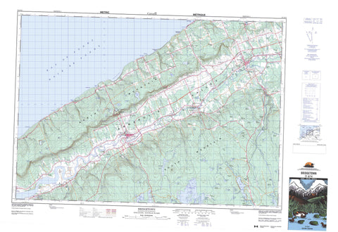
021A14 Bridgetown Canada topo map, 1:50,000 scale
021A14 Bridgetown NRCAN topographic map.
Includes UTM and GPS geographic coordinates (latitude and longitude). This 50k scale map is suitable for hiking, camping, and exploring, or you could frame it as a wall map.
Printed on-demand using high resolution, on heavy weight and acid free paper, or as an upgrade on a variety of synthetic materials.
Topos available on paper, Waterproof, Poly, or Tyvek. Usually shipping rolled, unless combined with other folded maps in one order.
- Product Number: NRCAN-021A14
- Parent Topo: TOPO-021A
- Map ID also known as: 021A14, 21A14
- Unfolded Size: Approximately 26" high by 36" wide
- Weight (paper map): ca. 55 grams
- Map Type: POD NRCAN Topographic Map
- Map Scale: 1:50,000
- Geographical region: Nova Scotia, Canada
Neighboring Maps:
All neighboring Canadian topo maps are available for sale online at 1:50,000 scale.
Purchase the smaller scale map covering this area: Topo-021A
Spatial coverage:
Topo map sheet 021A14 Bridgetown covers the following places:
- Baie de Fundy - Bay of Fundy - Chute Cove - Cottage Cove - Hampton Cove - Phinney Cove - Phinneys Cove - Port Lorne - Saw Mill Creek - St. Croix Cove - Ste. Croix Bay - Thornes Cove - Young Cove - Youngs Cove - Keatings Sand Beach - Small Keatings Sand Beach - Haystack Point - Seal Point - Steadmans Point - The Narrows - Scotchmans Lip - Taylors Falls - Wamboldt Falls - Annapolis - Grass Island - Mutton Island - Smiths Island - The Island - Baltzer Lake - Birch Hill Lake - Cedar Lake - Chute Lake - Clements Lake - Corbett Lake - Cranberry Lake - Croskill Lake - Dalhousie Lake - Duck Pond - East Branch Lake - Eaton Lake - Eel Weir Lake - Elbow Lake - Elliott Lake - Fellows Lake - First Grimm Lake - First Lake - Foster Lake - Gesner Lake - Lily Lake - Long Lake - Longley Lake - McEwan Lake - McKenzie Lake - Merrys Mill Pond - Milburn Lake - Milbury Lake - Mud Lake - Paradise Lake - Paradise Lake Flowage - Phinneys Pond - Ramsey Lake - Ruggles Lake - Rumsey Lake - Sandy Lake - Scrag Lake - Second Grimm Lake - Second Lake - Shannon Lake - Snow Lake - Snowshoe Lake - Tellier Lake - Third Grimm Lake - Third Lake - Trout Lake - Wade Lake - Walker Lake - Wamboldt Lake - Young Lake - Youngs Lake - Birch Hill - Hiram Layte Hill - North Mountain - North Mountain Range - South Mountain - Weasel Hill - Whynotts Hill - Annapolis - Bloody Creek National Historic Site of Canada - Lieu historique national du Canada Bloody Creek - Valleyview Provincial Park - Alpena Rapids - Beals Eddy - Big Rapids - Flat Rapids - Annapolis River - Barteaux Brook - Bath Brook - Beals Brook - Beeler Brook - Bent Brook - Black River - Bloody Creek - Bloody Creek - Bloody Creek Brook - Brown Brook - Burbidge Brook - Button Brook - Chesley Brook - Chute Brook - Daniels Brook - Delanceys Brook - East Branch Brook - East Troop Brook - Eaton Brook - Eben Young Brook - Eel Weir Brook - Evans Brook - Evans Brook - Fash Brook - Foster Brook - Fraser Brook - Gaskill Brook - Gehues Brook - Gesner Brook - Glebe Brook - Granville Line Brook - Grimm Lake Brook - Hampton Brook - Hannam Brook - Hardwood Brook - Hazelwood Brook - Healeys Brook - Hiram Young Brook - Hogan Brook - Hollow Brook - Hooper Brook - Joe Brook - Jones Brook - Joudrey Brook - Keith Brook - Kelly Brook - Kempt Brook - Lake Brook - Leonard Brook - Lily Lake Brook - Little John Brook - Luxton Brook - McEwan Brook - Messenger Brook - Miller Brook - Millers Brook - Mills Brook - Mochelle Brook - Morton Brook - Moschelle Brook - Mosher Brook - Munros Brook - Nass Weir Brook - Neily Brook - Nictaux River - Number Five Brook - Oak Hollow Brook - Oakes Brook - Oaks Brook - Oates Brook - Paradise Brook - Paradise Brook - Parker Brook - Peck Brook - Petes Brook - Phinneys Brook - Poole Brook - Port George Brook - Ray Brook - Robinson Brook - Round Hill River - Roxbury Brook - Sabeans Brook - Saunders Brook - Saunders West Brook - Schoolhouse Brook - Shearer Brook - Sheep Shearer Brook - Sheep Shearer Brook - Sheridan Brook - Slobbery Meadow Brook - Slokum Brook - Smith Brook - Snow Brook - Snowshoe Brook - Solomon Chute Brook - Spurr Brook - Starratt Brook - Steadmans Brook - Torbrook River - Troop Brook - Troop Brook - Tupper Brook - Waterloo River - Watton Brook - Wheelock Meadows Brook - Whitman Brook - Wiswal Brook - Big Stillwater - Cemetery Pool - Delanceys Pool - Flat Rapids Pool - Margeson Pool - Stump Pool - Dunns Rock - Bridgetown - Middleton - Albany - Alpena - Arlington West - Beaconsfield - Belleisle - Bloomington - Brickton - Bridgetown Wye - Brooklyn - Carleton Corner - Central Clarence - Centrelea - Church Road - Clarence - Clarence East - Clarence West - Douglas Road - East Arlington - East Inglisville - Elliott - Gates Mountain - Granville Centre - Hampton - Inglewood - Inglisville - Lower Middleton - Middleton Junction - Mochelle - Moschelle - Mount Hanley - Mount Hanly - Mount Rose - New Albany - Nictaux - Nictaux East - Nictaux Falls - Nictaux South - Nictaux West - North Williamston - Outram - Paradise - Phinney Cove - Phinneys Cove - Port Lorne - Round Hill - Roxbury - South Williamston - Spa Springs - Squirreltown - St. Croix Cove - Ste. Croix Cove - Torbrook West - Tupperville - Upper Clarence - Upper Granville - Victoria Vale - West Brooklyn - West Inglisville - West Lawrencetown - West Paradise - Wilmot - Wilmot Station - Young Cove - Youngs Cove - Annapolis Valley - Barteaux Meadows - Beals Meadows - Belleisle Marsh - Callaghan Meadows - Cowling Meadows - Crispe Bog - Crispe Meadows - McEwan Meadows - Miller Meadows - Parker Meadows - Pré Rond Marsh - Smith Meadows - The Wet Meadows - Thornes Meadows - Wheelock Meadows - Lawrencetown


