
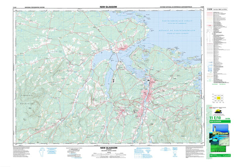
011E10 New Glasgow Canada topo map, 1:50,000 scale
011E10 New Glasgow NRCAN topographic map.
Includes UTM and GPS geographic coordinates (latitude and longitude). This 50k scale map is suitable for hiking, camping, and exploring, or you could frame it as a wall map.
Printed on-demand using high resolution, on heavy weight and acid free paper, or as an upgrade on a variety of synthetic materials.
Topos available on paper, Waterproof, Poly, or Tyvek. Usually shipping rolled, unless combined with other folded maps in one order.
- Product Number: NRCAN-011E10
- Parent Topo: TOPO-011E
- Map ID also known as: 011E10, 11E10
- Unfolded Size: Approximately 26" high by 36" wide
- Weight (paper map): ca. 55 grams
- Map Type: POD NRCAN Topographic Map
- Map Scale: 1:50,000
- Geographical region: Nova Scotia, Canada
Neighboring Maps:
All neighboring Canadian topo maps are available for sale online at 1:50,000 scale.
Purchase the smaller scale map covering this area: Topo-011E
Spatial coverage:
Topo map sheet 011E10 New Glasgow covers the following places:
- Back Harbour - Big Cove - Big Gut - Blackhall Gut - Boat Harbour - Caribou Harbour - Chance Harbour - Chapel Cove - Charltons Cove - Deacon Cove - Golfe du Saint-Laurent - Grattos Cove - Gulf of St. Lawrence - Haliburton Cove - Hansons Cove - Howletts Cove - Jessies Cove - Little Gut - Little Harbour - Merigomish Harbour - Moodie Cove - Pictou Harbour - Pictou Road - Pine Tree Gut - Pinetree Gut - Powell Cove - Powells Cove - Sandy Cove - Three Brooks - Town Gut - Websters Gully - Chance Harbour Beach - James Beach - Lighthouse Beach - Loudon Beach - Lowdens Beach - Melmerby Beach - Sinclairs Island Beach - Abercrombie Point - Albion Point - Battery Point - Begg Point - Black Point - Brown Point - Browns Point - Campbell Point - Cantley Point - Christie Point - Cole Point - Colquhoun Point - Doctor Point - Doctor Spit - Dunbar Point - Evans Point - Fortyfour Point - Forty-Four Point - Grave Point - Greens Point - Howletts Point - Indian Cross Point - Kenneth Point - Lank Point - Little Caribou Spit - Loch Broom Point - Lochbroom Point - Logan Point - Logans Point - Mackenzie Head - Mackenzie Point - MacNeils Point - McKay Point - Monroe Point - Moodie Point - Munroe Point - Munroes Point - Mussel Point - Neill Point - Norway Point - Oak Tree Point - Patterson Point - Pictou Bar Spit - Pine Point - Powell Point - Powells Head - Powells Point - Roaring Bull Point - Seaview Point - Shipyard Point - Skinner Point - Spring Point - Stonehouse Point - The Loading Ground - Town Point - Widow Point - Big Caribou Entrance - Détroit de Northumberland - Inside Channel - Little Caribou Entrance - Main Channel - North Entrance - Northumberland Strait - The Sluice - Parks Falls - Pictou - Boat Harbour West 37 - Fisher's Grant 24 - Fisher's Grant 24G - Fishers Grant Indian Reserve 24 - Fishers Grant Indian Reserve 24G - Réserve indienne Fishers Grant 24 - Réserve indienne Fishers Grant 24G - Ballast Island - Blueberry Island - Bowen Island - Burnt Island - Caribou Island - Doctor Island - Gavin Islet - Little Caribou Island - Loch Broom Islet - Lochbroom Islet - Mackenzie Island - Muless Island - Munroes Island - Quarry Island - Ram Island - Raspberry Island - Roy Island - Sinclairs Island - Spoon Island - The Intervale - Chance Harbour Lake - East Lake - Fergusons Pond - Forbes Lake - Grahams Pond - James Ponds - MacKays Pond - Otter Pond - West Lake - Anderson Mountain - Beech Hill - Campbell Hill - Cobequid Mountains - Dalhousie Mountain - Durham Hill - Fitzpatrick Mountain - Fitzpatricks Mountain - Fraser Mountain - Frasers Mountain - Green Hill - Hardwood Hill - Hungry Hill - Irish Mountain - McGregor Mountain - McLellan Mountain - McLellans Mountain - Mount Ephraim - Mount Thom - Rogers Hill - Rory Bans Hill - Scotch Hill - Tanner Hill - Pictou - Abercrombie Wildlife Management Area - Caribou Provincial Park - Caribou-Munroes Island Provincial Park - Greenhill Provincial Park - Melmerby Beach Provincial Park - Powells Point Provincial Park - Salt Springs Provincial Park - Anderson Brook - Bear Brook - Begg Brook - Benbie Brook - Big Caribou River - Black River - Bore Hole Brook - Brown Brook - Cameron Brook - Caribou River - Clish Brook - Diamond Brook - East Branch River John - East River - East River of Pictou - Eight Mile Brook - Eightmile Brook - Fall Brook - Four Mile Brook - Fourmile Brook - Fox Brook - Graham Brook - Haliburton Brook - Hugh Brook - Little Caribou River - Little River - Lowden Brook - Lyon Brook - Lyons Brook - MacKay Brook - Manse Brook - McCulloch Brook - McLean Brook - McLellan Brook - McLellans Brook - Middle River - Middle River of Pictou - Mill Brook - Mill Brook - Miller Brook - Pine Tree Brook - Pinetree Brook - Plainfield Brook - Potter Brook - Potters Brook - Quaker Brook - Quarry Brook - Rear Brook - Ross Brook - Sawmill Brook - School Brook - Shale Brook - Sheriff Brook - Six Mile Brook - Sixmile Brook - Skinner Brook - Small Brook - Smalls Brook - Smelt Brook - Steele Run - Steep Brook - Stewart Brook - Sutherland River - Sutherlands River - Sweet Brook - Toney River - Waters Brook - Watervale Brook - West Branch East River - West River - West River of Pictou - West Toney River - Skinners Reef - Cole Reef - Doctor Reef - Macdonald Reef - Mackenzie Shoal - Murdock Shoal - Pocahontas Rock - Roaring Bull - Roy Ledge - Seal Rock - Sheas Rock - Skinner Reef - Skinners Reef - Western Reef - New Glasgow - Pictou - Stellarton - Trenton - Westville - Abercrombie - Academy - Alma - Anderson Mountain - Bay View - Bigney - Black Point - Black River - Blue Acres - Braeshore - Brookland - Brown Point - Browns Point - Caribou - Caribou Ferry - Caribou Island - Central Caribou - Central West River - Chance Harbour - Chattan Park - Churchville - Coalburn - Dalhousie Settlement - Diamond - Dufferin - Durham - Elmfield - Ferrona Junction - Fitzpatricks Mountain - Four Mile Brook - Fourmile Brook - Fox Brook - Frasers Mountain - Glenfalloch - Granton - Greenhill - Greens Point - Greenwood - Haliburton - Hardwood Hill - Hazel Glen - Heathbell - Hillside - Hodson - Kings Head - Kirkmount - Limerock - Linacy - Little Egypt Road - Little Harbour - Little Harbour Road - Loch Broom - Lochbroom - Logan Subdivision - Lourdes - Lovat - Lower Mount Thom - Lyons Brook - Lyons Brook - MacDonald's - Marshall - Marshalls Crossing - McLellan Brook - McLellan Mountain - McLellans Brook - McLellans Mountain - McPhersons Mills - Meadowville - Micmac - Millbrook - Millsville - Mount William - Mountville - Pictou Landing - Pine Tree - Pinetree - Plainfield - Pleasant Valley - Plymouth - Plymouth Park - Poplar Hill - Priestville - Riverton - Riverton Heights - Riverview - Rockfield - Rogers - Rogers Hill - Rogers Hill Cross Roads - Salt Springs - Satellite Slopes - Scotch Hill - Scotsburn - Six Mile Brook - Stillman - Sundridge - Sutherland - Sutherland River - Sutherlands River - Sylvester - Terrace Heights - The Meadows - Thorburn - Three Brooks - Union Centre - Upper Mount Thom - West River - Woodbourne - Woodburn - Woodburn Station - Big Bog - Big Meadow - MacLeods Meadow - Sutherland Bog


