
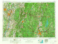
~ Albany NY topo map, 1:250000 scale, 1 X 2 Degree, Historical, 1956, updated 1968
Albany, New York, USGS topographic map dated 1956.
Includes geographic coordinates (latitude and longitude). This topographic map is suitable for hiking, camping, and exploring, or framing it as a wall map.
Printed on-demand using high resolution imagery, on heavy weight and acid free paper, or alternatively on a variety of synthetic materials.
Topos available on paper, Waterproof, Poly, or Tyvek. Usually shipping rolled, unless combined with other folded maps in one order.
- Product Number: USGS-5454809
- Free digital map download (high-resolution, GeoPDF): Albany, New York (file size: 19 MB)
- Map Size: please refer to the dimensions of the GeoPDF map above
- Weight (paper map): ca. 55 grams
- Map Type: POD USGS Topographic Map
- Map Series: HTMC
- Map Verison: Historical
- Cell ID: 68639
- Scan ID: 136555
- Imprint Year: 1968
- Woodland Tint: Yes
- Visual Version Number: 1
- Edit Year: 1967
- Field Check Year: 1956
- Datum: Unstated
- Map Projection: Transverse Mercator
- Map published by United States Army
- Map Language: English
- Scanner Resolution: 600 dpi
- Map Cell Name: Albany
- Grid size: 1 X 2 Degree
- Date on map: 1956
- Map Scale: 1:250000
- Geographical region: New York, United States
Neighboring Maps:
All neighboring USGS topo maps are available for sale online at a variety of scales.
Spatial coverage:
Topo map Albany, New York, covers the geographical area associated the following places:
- Clifton Park Center - Tomaselli Estates - East Northfield - Latham - Poolsburg - Flatbrook - Springdale - West Summit - Heald Village - Carlyle Court - Green Island - Reynolds - Springfield - Taconic - Hales Crossing - Chicopee Falls - Williamsville - East Swanzey - Flagler Corners - Cairo Junction - West Copake - Lake Pleasant - Williamsville - Montague - Hoosac Tunnel Station - Prescott Center - Lake Ridge - Lincolnville - Barkerville - Yankee Orchards - Blue Store - North Otis - Montague City - Holland - Veteran - Shattuckville - Southampton - Thermopylae - Dwight - Shea Corner - Chatham - Brookview - Cherryplain - Hubbardston - Hartsville - Foundry Village - Thorndike - East Renfrew - Stanford Heights - Knightville - Beechwood Estates - Sandersdale - Fullers - Tucker Heights - Schodack Landing - Zoar - Beachwood - New Salem - Hollowville - South Schenectady - Meadowdale - North Hadley - Cairo - Harper Acres - Sunderland - Moody Corner - Amostown - West Rindge - Camp Marion White - New Lebanon Center - Baptist Corner - Adams Crossing Mobile Home Park - Oakwood Terrace - South Barre - Goose City - Sodom - Red Mills - Orange - Camp Woronoak - Stillwater - North Agawam - Mill River - Blanchardville - South Royalston - Athol - East Pittstown - Liberty Heights - North Heath - Guilford Center - Van Deusenville - South Keene - Maple Grove - Bondsville - Viewmonte - Factory Hollow - Halladay Corner - Riverside - Coldbrook - Eastview - Goulding Village
- Map Area ID: AREA4342-74-72
- Northwest corner Lat/Long code: USGSNW43-74
- Northeast corner Lat/Long code: USGSNE43-72
- Southwest corner Lat/Long code: USGSSW42-74
- Southeast corner Lat/Long code: USGSSE42-72
- Northern map edge Latitude: 43
- Southern map edge Latitude: 42
- Western map edge Longitude: -74
- Eastern map edge Longitude: -72


