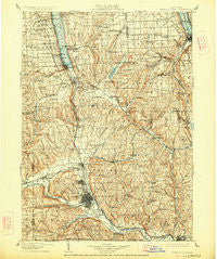
~ Watkins Glen NY topo map, 1:125000 scale, 30 X 30 Minute, Historical, 1905, updated 1927
Watkins Glen, New York, USGS topographic map dated 1905.
Includes geographic coordinates (latitude and longitude). This topographic map is suitable for hiking, camping, and exploring, or framing it as a wall map.
Printed on-demand using high resolution imagery, on heavy weight and acid free paper, or alternatively on a variety of synthetic materials.
Topos available on paper, Waterproof, Poly, or Tyvek. Usually shipping rolled, unless combined with other folded maps in one order.
- Product Number: USGS-5454799
- Free digital map download (high-resolution, GeoPDF): Watkins Glen, New York (file size: 10 MB)
- Map Size: please refer to the dimensions of the GeoPDF map above
- Weight (paper map): ca. 55 grams
- Map Type: POD USGS Topographic Map
- Map Series: HTMC
- Map Verison: Historical
- Cell ID: 66894
- Scan ID: 144553
- Imprint Year: 1927
- Survey Year: 1899
- Datum: NAD
- Map Projection: Polyconic
- Map published by United States Geological Survey
- Map Language: English
- Scanner Resolution: 600 dpi
- Map Cell Name: Watkinsglen
- Grid size: 30 X 30 Minute
- Date on map: 1905
- Map Scale: 1:125000
- Geographical region: New York, United States
Neighboring Maps:
All neighboring USGS topo maps are available for sale online at a variety of scales.
Spatial coverage:
Topo map Watkins Glen, New York, covers the geographical area associated the following places:
- Seeley Creek - Holly Park Terrace - Cayutaville - Van Dorn Corner - Harris Hill Manor - Cayuta - Pioneer Village - Maplehurst Park - Cherry Lane - Cloverland Park - Alpine Junction - Birchland Park - Bennettsburg - Krum Corner - Big Flats - Rock Stream - North Spencer - Trumbull Corners - Burdett - Applegate Corner - Elmira - East Corning - Rolling Acres Mobile Home Park - Irelandville - Elmira Heights - Pine Valley - Meadowbrook Park - Moreland - Whipple Corner - Owens Mills - Odessa - Newfield - Green Valley Mobile Home Park - Millport - Pine City - Townsend - Webb Mills - Erin Estates - Montour Falls - Tompkins Corners - Beaver Dams - Sandy Creek Mobile Home Park - College View Trailer Park - Enfield - West Elmira - East Elmira - West Danby - Butternut Park - Stratton - Orchard Knoll - North Reading - Swartwood - Deckertown - McKinneys - Brookside Mobile Home Park - Horseheads - Lowman - Goff Road Mobile Home Park - Erin - Post Creek - Dewittsburg Park Housing Project - Van Etten - Rush Run - East Waverly - Kennedy Corner - Collingwood - Cedar Park Terrace - Golden Glow Heights - North Chemung - Logan - Glenora - Smith Valley - Breesport - Shelter Valley Mobile Home Park - Retirement Estates - Hoffman Plaza Housing Project - Wedgewood - Carriage Estates - Christian Hill - Van Etten Junction - Southport - Rosstown - Hathorn Court - Midway - Perry City - Brookhaven - Hayt Corner - Havana Glen Mobile Home Park - Catharine - North Star Manufactured Home Community - Wildwood Mobile Home Park - Fisherville - Alpine - Chambers - Sagetown - Wellsburg - Waverly - Reniff - Watkins Glen - Mecklenburg
- Map Area ID: AREA42.542-77-76.5
- Northwest corner Lat/Long code: USGSNW42.5-77
- Northeast corner Lat/Long code: USGSNE42.5-76.5
- Southwest corner Lat/Long code: USGSSW42-77
- Southeast corner Lat/Long code: USGSSE42-76.5
- Northern map edge Latitude: 42.5
- Southern map edge Latitude: 42
- Western map edge Longitude: -77
- Eastern map edge Longitude: -76.5

