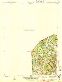
~ Ayers Village NH topo map, 1:31680 scale, 7.5 X 7.5 Minute, Historical, 1943
Ayers Village, New Hampshire, USGS topographic map dated 1943.
Includes geographic coordinates (latitude and longitude). This topographic map is suitable for hiking, camping, and exploring, or framing it as a wall map.
Printed on-demand using high resolution imagery, on heavy weight and acid free paper, or alternatively on a variety of synthetic materials.
Topos available on paper, Waterproof, Poly, or Tyvek. Usually shipping rolled, unless combined with other folded maps in one order.
- Product Number: USGS-5583118
- Free digital map download (high-resolution, GeoPDF): Ayers Village, New Hampshire (file size: 5 MB)
- Map Size: please refer to the dimensions of the GeoPDF map above
- Weight (paper map): ca. 55 grams
- Map Type: POD USGS Topographic Map
- Map Series: HTMC
- Map Verison: Historical
- Cell ID: 39437
- Scan ID: 329922
- Woodland Tint: Yes
- Survey Year: 1942
- Datum: NAD27
- Map Projection: Polyconic
- Map published by United States Geological Survey
- Map Language: English
- Scanner Resolution: 600 dpi
- Map Cell Name: Salem Depot
- Grid size: 7.5 X 7.5 Minute
- Date on map: 1943
- Map Scale: 1:31680
- Geographical region: New Hampshire, United States
Neighboring Maps:
All neighboring USGS topo maps are available for sale online at a variety of scales.
Spatial coverage:
Topo map Ayers Village, New Hampshire, covers the geographical area associated the following places:
- Pine Grove Park - West Parish - Tozier Corner - Salem Depot - North Salem - Ayers Village - Foster Corners - Atkinson - Maple Park - Wilson Corners - Cowbell Corners - Grosvenor Corner - Salem - Canobie Lake - Arlington Park - Howards Grove - Atkinson Heights - Noyes Terrace - Conleys Grove - Graceland Park - Millville - Hampstead - Cluffs Crossing - Chases Grove
- Map Area ID: AREA42.87542.75-71.25-71.125
- Northwest corner Lat/Long code: USGSNW42.875-71.25
- Northeast corner Lat/Long code: USGSNE42.875-71.125
- Southwest corner Lat/Long code: USGSSW42.75-71.25
- Southeast corner Lat/Long code: USGSSE42.75-71.125
- Northern map edge Latitude: 42.875
- Southern map edge Latitude: 42.75
- Western map edge Longitude: -71.25
- Eastern map edge Longitude: -71.125