
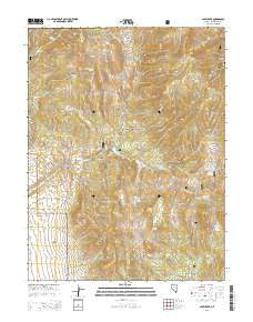
~ Cave Creek NV topo map, 1:24000 scale, 7.5 X 7.5 Minute, 2014
Cave Creek, Nevada, USGS topographic map dated 2014.
Includes geographic coordinates (latitude and longitude). This topographic map is suitable for hiking, camping, and exploring, or framing it as a wall map.
Printed on-demand using high resolution imagery, on heavy weight and acid free paper, or alternatively on a variety of synthetic materials.
Topos available on paper, Waterproof, Poly, or Tyvek. Usually shipping rolled, unless combined with other folded maps in one order.
- Product Number: USGS-7171300
- Free digital map download (high-resolution, GeoPDF): Cave Creek, Nevada (file size: 30 MB)
- Map Size: please refer to the dimensions of the GeoPDF map above
- Weight (paper map): ca. 55 grams
- Map Type: POD USGS Topographic Map
- Map Series: US Topo
- Map Verison: Current
- Cell ID: 7713
- Datum: North American Datum of 1983
- Map Projection: Transverse Mercator
- Map Cell Name: Cave Creek
- Grid size: 7.5 X 7.5 Minute
- Date on map: 2014
- Map Scale: 1:24000
- Geographical region: Nevada, United States
Neighboring Maps:
All neighboring USGS topo maps are available for sale online at a variety of scales.
Spatial coverage:
Topo map Cave Creek, Nevada, covers the geographical area associated the following places:
- Schell Creek Range - Clear Spring - Nevada Mining District - Clear Creek - Square Top - Kolcheck Mine - South Fork Steptoe Creek - Elk Flat Campground - Summit Spring - Grasshopper Canyon - South Fork Spring - East Canyon Spring - Cave Creek Spring - Grasshopper Spring - Camel Peak - North Spring - Tamberlaine Spring - Cave Creek - Cave Springs - Cave Creek Reservoir - South Fork Cave Creek - Cooper Summit - Cave Lake State Park - Aspen Spring - Cave Lake Forest Service Recreation Site - Mosier Spring - The Narrows - Cave Creek Dam - Aspen Spring
- Map Area ID: AREA39.2539.125-114.75-114.625
- Northwest corner Lat/Long code: USGSNW39.25-114.75
- Northeast corner Lat/Long code: USGSNE39.25-114.625
- Southwest corner Lat/Long code: USGSSW39.125-114.75
- Southeast corner Lat/Long code: USGSSE39.125-114.625
- Northern map edge Latitude: 39.25
- Southern map edge Latitude: 39.125
- Western map edge Longitude: -114.75
- Eastern map edge Longitude: -114.625


