
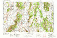
~ Lund NV topo map, 1:250000 scale, 1 X 2 Degree, Historical, 1956, updated 1972
Lund, Nevada, USGS topographic map dated 1956.
Includes geographic coordinates (latitude and longitude). This topographic map is suitable for hiking, camping, and exploring, or framing it as a wall map.
Printed on-demand using high resolution imagery, on heavy weight and acid free paper, or alternatively on a variety of synthetic materials.
Topos available on paper, Waterproof, Poly, or Tyvek. Usually shipping rolled, unless combined with other folded maps in one order.
- Product Number: USGS-5573818
- Free digital map download (high-resolution, GeoPDF): Lund, Nevada (file size: 22 MB)
- Map Size: please refer to the dimensions of the GeoPDF map above
- Weight (paper map): ca. 55 grams
- Map Type: POD USGS Topographic Map
- Map Series: HTMC
- Map Verison: Historical
- Cell ID: 72236
- Scan ID: 321732
- Imprint Year: 1972
- Woodland Tint: Yes
- Aerial Photo Year: 1954
- Edit Year: 1970
- Field Check Year: 1956
- Datum: Unstated
- Map Projection: Transverse Mercator
- Map published by United States Geological Survey
- Map published by: Military, Other
- Map Language: English
- Scanner Resolution: 600 dpi
- Map Cell Name: Lund
- Grid size: 1 X 2 Degree
- Date on map: 1956
- Map Scale: 1:250000
- Geographical region: Nevada, United States
Neighboring Maps:
All neighboring USGS topo maps are available for sale online at a variety of scales.
Spatial coverage:
Topo map Lund, Nevada, covers the geographical area associated the following places:
- Duckwater - Lockes - Oneota (historical) - Cedarhurst (historical) - Cave Valley (historical) - Atlanta - Newland (historical) - Karo (historical) - Geyser (historical) - White River (historical) - Patterson (historical) - Shoshone - Bristol - Currant - Grant City (historical) - Ruppes Place - Garrison - Nyala - Pony Springs - Hot Creek - Sunnyside - Barnes (historical) - Mud Springs - Stockville (historical) - Coyote (historical) - Bristol Well (historical) - Preston - Troy (historical) - Crows Nest - Spring Valley (historical) - Douglas - Allred (historical) - Wilson Creek (historical) - Jackrabbit (historical) - Minerva - Gold Point (historical) - Lund - Adaven - Tempest (historical) - Montezuma (historical)
- Map Area ID: AREA3938-116-114
- Northwest corner Lat/Long code: USGSNW39-116
- Northeast corner Lat/Long code: USGSNE39-114
- Southwest corner Lat/Long code: USGSSW38-116
- Southeast corner Lat/Long code: USGSSE38-114
- Northern map edge Latitude: 39
- Southern map edge Latitude: 38
- Western map edge Longitude: -116
- Eastern map edge Longitude: -114


