
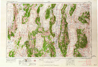
~ Ely NV topo map, 1:250000 scale, 1 X 2 Degree, Historical, 1963, updated 1963
Ely, Nevada, USGS topographic map dated 1963.
Includes geographic coordinates (latitude and longitude). This topographic map is suitable for hiking, camping, and exploring, or framing it as a wall map.
Printed on-demand using high resolution imagery, on heavy weight and acid free paper, or alternatively on a variety of synthetic materials.
Topos available on paper, Waterproof, Poly, or Tyvek. Usually shipping rolled, unless combined with other folded maps in one order.
- Product Number: USGS-5573760
- Free digital map download (high-resolution, GeoPDF): Ely, Nevada (file size: 21 MB)
- Map Size: please refer to the dimensions of the GeoPDF map above
- Weight (paper map): ca. 55 grams
- Map Type: POD USGS Topographic Map
- Map Series: HTMC
- Map Verison: Historical
- Cell ID: 68767
- Scan ID: 321669
- Imprint Year: 1963
- Woodland Tint: Yes
- Aerial Photo Year: 1954
- Edit Year: 1962
- Field Check Year: 1956
- Datum: Unstated
- Map Projection: Transverse Mercator
- Map published by United States Army Corps of Engineers
- Map published by United States Army
- Map Language: English
- Scanner Resolution: 600 dpi
- Map Cell Name: Ely
- Grid size: 1 X 2 Degree
- Date on map: 1963
- Map Scale: 1:250000
- Geographical region: Nevada, United States
Neighboring Maps:
All neighboring USGS topo maps are available for sale online at a variety of scales.
Spatial coverage:
Topo map Ely, Nevada, covers the geographical area associated the following places:
- Copper Flat - Robinson (historical) - Cleveland (historical) - San Pedro (historical) - Tippett - East Ely - Egan (historical) - Lane City - Greenville (historical) - Cherry Creek - Ruth - Kimberly - Hamilton - Melvin (historical) - Swansea (historical) - Majors Place - Veteran (historical) - Yelland (historical) - Mineral City - Adverse - Keystone - Riepetown - Glencoe (historical) - Bassett (historical) - Eureka - Keystone Junction - Cooper (historical) - Kent (historical) - Taylor (historical) - Sunshine Camp (historical) - Ward (historical) - Baker - Taft (historical) - Ruby Hill - Tamerlane (historical) - Seligman (historical) - Green Springs - Menken (historical) - Warm Springs - Osceola - Treasure City (historical) - Pinto (historical) - Pinto (historical) - Uvada (historical) - Birch (historical) - Diamond City (historical) - Illipah (historical) - Regan (historical) - Calumet - Aurum (historical) - Shermantown - Ruby Hill (historical) - Mosier - Hogum - Steptoe - Picotillo (historical) - Tungstonia (historical) - Hunter (historical) - Goshute - Joy (historical) - Simonsen (historical) - Centerville (historical) - White Pine City (historical) - Ruth (historical) - Siegel (historical) - Baltimore Mill - Pleasant Valley (historical) - Lavon - Willow Grove - Muncy (historical) - Eberhardt - Black Horse (historical) - McGill Junction - McCoy (historical) - Parker (historical) - McGill - Pogonip - Bull Fork - Eunice Place - Stonehouse - Strawberry (historical) - Babylon (historical) - Vanderbilt (historical) - Newark (historical) - Ely - Glenn
- Map Area ID: AREA4039-116-114
- Northwest corner Lat/Long code: USGSNW40-116
- Northeast corner Lat/Long code: USGSNE40-114
- Southwest corner Lat/Long code: USGSSW39-116
- Southeast corner Lat/Long code: USGSSE39-114
- Northern map edge Latitude: 40
- Southern map edge Latitude: 39
- Western map edge Longitude: -116
- Eastern map edge Longitude: -114


