
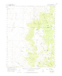
~ Wildcat Peak NV topo map, 1:62500 scale, 15 X 15 Minute, Historical, 1960, updated 1975
Wildcat Peak, Nevada, USGS topographic map dated 1960.
Includes geographic coordinates (latitude and longitude). This topographic map is suitable for hiking, camping, and exploring, or framing it as a wall map.
Printed on-demand using high resolution imagery, on heavy weight and acid free paper, or alternatively on a variety of synthetic materials.
Topos available on paper, Waterproof, Poly, or Tyvek. Usually shipping rolled, unless combined with other folded maps in one order.
- Product Number: USGS-5573418
- Free digital map download (high-resolution, GeoPDF): Wildcat Peak, Nevada (file size: 5 MB)
- Map Size: please refer to the dimensions of the GeoPDF map above
- Weight (paper map): ca. 55 grams
- Map Type: POD USGS Topographic Map
- Map Series: HTMC
- Map Verison: Historical
- Cell ID: 64538
- Scan ID: 321457
- Imprint Year: 1975
- Woodland Tint: Yes
- Aerial Photo Year: 1956
- Survey Year: 1960
- Datum: NAD27
- Map Projection: Polyconic
- Map published by United States Geological Survey
- Map Language: English
- Scanner Resolution: 600 dpi
- Map Cell Name: Wildcat Peak
- Grid size: 15 X 15 Minute
- Date on map: 1960
- Map Scale: 1:62500
- Geographical region: Nevada, United States
Neighboring Maps:
All neighboring USGS topo maps are available for sale online at a variety of scales.
Spatial coverage:
Topo map Wildcat Peak, Nevada, covers the geographical area associated the following places:
- Iron Spring - Henry Meyer Canyon - North Fork Wildcat Canyon - Indian Blue Mine - Lone Butte - Kingston Creek - Clipper Gap Spring - Petes Summit - Boulder Canyon - Diana Peak - Henry Meyer Spring - Wildcat Canyon - Jeans Spring - West Northumberland Canyon - Wildcat Peak - Willow Canyon - Turquoise Spring - White Rock Canyon - Corral Canyon - Sawlog Ridge - Alkali Flat Well - Sage Hen Spring - South Fork Wildcat Canyon - Tor Peak - Sams Spring - Rock Creek - Clipper Gap Canyon - Clipper Gap - Gatecliff - Petes Spring - Triple T Well - West Knob - Copper Mine Spring - Deer Spring - Trail Canyon - White Rock Mountain - Wildcat Spring - Lost Spring - Bronco Mine - Hoodoo Canyon - Birch Creek - White Rock Spring - Masket Peak - Little Stoneberger Creek - Indian Ranch - Stoneberger Basin
- Map Area ID: AREA39.2539-117-116.75
- Northwest corner Lat/Long code: USGSNW39.25-117
- Northeast corner Lat/Long code: USGSNE39.25-116.75
- Southwest corner Lat/Long code: USGSSW39-117
- Southeast corner Lat/Long code: USGSSE39-116.75
- Northern map edge Latitude: 39.25
- Southern map edge Latitude: 39
- Western map edge Longitude: -117
- Eastern map edge Longitude: -116.75


