
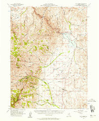
~ Wild Horse NV topo map, 1:62500 scale, 15 X 15 Minute, Historical, 1956, updated 1958
Wild Horse, Nevada, USGS topographic map dated 1956.
Includes geographic coordinates (latitude and longitude). This topographic map is suitable for hiking, camping, and exploring, or framing it as a wall map.
Printed on-demand using high resolution imagery, on heavy weight and acid free paper, or alternatively on a variety of synthetic materials.
Topos available on paper, Waterproof, Poly, or Tyvek. Usually shipping rolled, unless combined with other folded maps in one order.
- Product Number: USGS-5573412
- Free digital map download (high-resolution, GeoPDF): Wild Horse, Nevada (file size: 11 MB)
- Map Size: please refer to the dimensions of the GeoPDF map above
- Weight (paper map): ca. 55 grams
- Map Type: POD USGS Topographic Map
- Map Series: HTMC
- Map Verison: Historical
- Cell ID: 64534
- Scan ID: 321454
- Imprint Year: 1958
- Woodland Tint: Yes
- Aerial Photo Year: 1952
- Field Check Year: 1956
- Datum: NAD27
- Map Projection: Polyconic
- Map published by United States Geological Survey
- Map Language: English
- Scanner Resolution: 600 dpi
- Map Cell Name: Wild Horse
- Grid size: 15 X 15 Minute
- Date on map: 1956
- Map Scale: 1:62500
- Geographical region: Nevada, United States
Neighboring Maps:
All neighboring USGS topo maps are available for sale online at a variety of scales.
Spatial coverage:
Topo map Wild Horse, Nevada, covers the geographical area associated the following places:
- Wood Gulch Creek - Wildhorse Post Office (historical) - Hot Springs - Barn Gulch - Sammy Creek - Wild Horse Crossing - Wild Horse Crossing Campground - McAfee Creek - Big Spring - Peterson Creek - Hendricks Creek - Wild Horse Dam - Crooked Creek - Murphy Corral (historical) - Northfork Volunteer Fire Department - Fry Canyon - Wild Horse Reservoir - Stevens Ranch - Cole Canyon - Mikes Canyon - Red Mountain - Dry Canyon - Deer Creek - Cole Creek - North Wild Horse Creek - Lost Meadows Creek - Wild Horse - Byington Ranch - Road Canyon - Clear Creek - Sho-Pai Marina - Jacks Creek - Delaware Creek - Alexander Post Office (historical) - Mendive Ranch - Mountain City Ranger District - Badger Creek - North Fork Jack Creek Summit - Vega Ranch - Beadles Creek - Rim Canyon - Hansen Ranch - South Fork Deep Creek - Walker Creek - Poorman Spring - Hot Springs (historical) - Chicken Creek - Lost Meadows - Warm Creek - Deep Creek - Halls - Wood Gulch - Riffe Creek - McAfee Peak - North Wild Horse Campground - Middle Fork Deep Creek - Haystack Creek - Byington Ranch Airport (historical) - Harrison School (historical) - Wood Gulch Mine - Poorman Creek - Water Canyon - Beaver Creek - Clear Creek - Big Spring Creek - Wild Horse Range - Hot Creek - Big Springs Mill - Baker Ranch - Dell Creek - Springs Creek - Thompson Ranch - De Long Ridge - Gravel Creek - Hanks Creek - South Wild Horse Creek - Northfork Campgrounds - Spring Creek Ranch - Doheny Ranch - North Fork Deep Creek - Poorman Peak - Cow Canyon - Wild Horse State Recreation Area - Big Springs Mine - Penrod Creek - Machado Creek - Morse Ranch - Rocky Bluff - North Fork Guard Station - Stevens-Crosby Airport - Jeannette Lake - Warm Creek - Wild Horse Airport (historical) - Kearns Spring - Chicken Creek - Gardner Creek
- Map Area ID: AREA41.7541.5-116-115.75
- Northwest corner Lat/Long code: USGSNW41.75-116
- Northeast corner Lat/Long code: USGSNE41.75-115.75
- Southwest corner Lat/Long code: USGSSW41.5-116
- Southeast corner Lat/Long code: USGSSE41.5-115.75
- Northern map edge Latitude: 41.75
- Southern map edge Latitude: 41.5
- Western map edge Longitude: -116
- Eastern map edge Longitude: -115.75


