
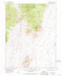
~ Moores Station NV topo map, 1:62500 scale, 15 X 15 Minute, Historical, 1967, updated 1971
Moores Station, Nevada, USGS topographic map dated 1967.
Includes geographic coordinates (latitude and longitude). This topographic map is suitable for hiking, camping, and exploring, or framing it as a wall map.
Printed on-demand using high resolution imagery, on heavy weight and acid free paper, or alternatively on a variety of synthetic materials.
Topos available on paper, Waterproof, Poly, or Tyvek. Usually shipping rolled, unless combined with other folded maps in one order.
- Product Number: USGS-5572822
- Free digital map download (high-resolution, GeoPDF): Moores Station, Nevada (file size: 6 MB)
- Map Size: please refer to the dimensions of the GeoPDF map above
- Weight (paper map): ca. 55 grams
- Map Type: POD USGS Topographic Map
- Map Series: HTMC
- Map Verison: Historical
- Cell ID: 57854
- Scan ID: 321089
- Imprint Year: 1971
- Woodland Tint: Yes
- Aerial Photo Year: 1967
- Field Check Year: 1967
- Datum: NAD27
- Map Projection: Polyconic
- Map published by United States Geological Survey
- Map Language: English
- Scanner Resolution: 600 dpi
- Map Cell Name: Moores Station
- Grid size: 15 X 15 Minute
- Date on map: 1967
- Map Scale: 1:62500
- Geographical region: Nevada, United States
Neighboring Maps:
All neighboring USGS topo maps are available for sale online at a variety of scales.
Spatial coverage:
Topo map Moores Station, Nevada, covers the geographical area associated the following places:
- Moores Station Buttes - Sorhonet Well Number Two - Williams Ridge - Cabin Creek - Jumbled Rock Gulch - Halligan Mesa - Middle Fork Chaos Creek - Logan Catch Basin - South Canyon - Petroglyph Butte - The Needles - Squaw Wells Spring - Sorhonet Well Number One - Needles Spring - Squaw Hills - Chaos Knob - Moores Station - Cruiser Point - Needles Catch Basin - North Fork Cabin Creek - Chaos Creek - South Fork Chaos Creek - Morey Canyon - Sixmile Well - Basalt Butte - Needle Range - Heart Hills - Shingle Buttes - Confusion Hills - North Canyon - Hacksaw Canyon - Slanted Buttes - Sand Springs Well - Antelope Well - Orange Lichen Creek
- Map Area ID: AREA38.7538.5-116.25-116
- Northwest corner Lat/Long code: USGSNW38.75-116.25
- Northeast corner Lat/Long code: USGSNE38.75-116
- Southwest corner Lat/Long code: USGSSW38.5-116.25
- Southeast corner Lat/Long code: USGSSE38.5-116
- Northern map edge Latitude: 38.75
- Southern map edge Latitude: 38.5
- Western map edge Longitude: -116.25
- Eastern map edge Longitude: -116


