
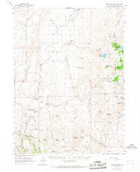
~ Idaho Canyon NV topo map, 1:62500 scale, 15 X 15 Minute, Historical, 1965, updated 1967
Idaho Canyon, Nevada, USGS topographic map dated 1965.
Includes geographic coordinates (latitude and longitude). This topographic map is suitable for hiking, camping, and exploring, or framing it as a wall map.
Printed on-demand using high resolution imagery, on heavy weight and acid free paper, or alternatively on a variety of synthetic materials.
Topos available on paper, Waterproof, Poly, or Tyvek. Usually shipping rolled, unless combined with other folded maps in one order.
- Product Number: USGS-5572670
- Free digital map download (high-resolution, GeoPDF): Idaho Canyon, Nevada (file size: 7 MB)
- Map Size: please refer to the dimensions of the GeoPDF map above
- Weight (paper map): ca. 55 grams
- Map Type: POD USGS Topographic Map
- Map Series: HTMC
- Map Verison: Historical
- Cell ID: 55651
- Scan ID: 321002
- Imprint Year: 1967
- Woodland Tint: Yes
- Aerial Photo Year: 1963
- Field Check Year: 1965
- Datum: NAD27
- Map Projection: Polyconic
- Map published by United States Geological Survey
- Map Language: English
- Scanner Resolution: 600 dpi
- Map Cell Name: Idaho Canyon
- Grid size: 15 X 15 Minute
- Date on map: 1965
- Map Scale: 1:62500
- Geographical region: Nevada, United States
Neighboring Maps:
All neighboring USGS topo maps are available for sale online at a variety of scales.
Spatial coverage:
Topo map Idaho Canyon, Nevada, covers the geographical area associated the following places:
- Woodcamp Springs - Summer Camp Canyon - Cow Creek - Rodeo Flat - New York Peak - Knott Creek Reservoir Dam - Cove Meadow Mining District - Summit Lake Division - Corral Creek - Idaho Canyon Spring - Buck Pasture - Wood Canyon - Rock Spring - Idaho Canyon Range - Bartlett Mine - Indian Spring - Gridley Springs - Juanita Mine - West Spring - Corral Spring - McCully Spring - Bartlett Peak - Cove Meadows - Wheeler Springs - Cove Meadow Mine - Pearl Camp - Center Creek - Lahontan Cutthroat Trout Natural Area - Dry Lake - Knott Creek Channel - Summer Camp - Dry Lake Springs - Trail Canyon - Little Onion Reservoir - Craine Spring - McCully Cabin - Columbia Mine - Alkali Flat - South Fork Mahogany Creek - Josie Pearl Spring - Middle Spring - Little Idaho Canyon - Lone Meadow Spring - Summit Lake Mountain - Pole Creek - Hollywood Meadow - Knott Creek Reservoir - Parman Spring - Horseshoe Bend - Cove Camp - Big Mountain - Knott Creek Ranch - Cove Creek - Willow Spring - Santa Claus Spring - Knott Creek - Tin Trough Spring - Little Onion Dam - Trough Spring - Stanley Camp - Idaho Canyon - Summit Spring - West Creek
- Map Area ID: AREA41.7541.5-119-118.75
- Northwest corner Lat/Long code: USGSNW41.75-119
- Northeast corner Lat/Long code: USGSNE41.75-118.75
- Southwest corner Lat/Long code: USGSSW41.5-119
- Southeast corner Lat/Long code: USGSSE41.5-118.75
- Northern map edge Latitude: 41.75
- Southern map edge Latitude: 41.5
- Western map edge Longitude: -119
- Eastern map edge Longitude: -118.75


