
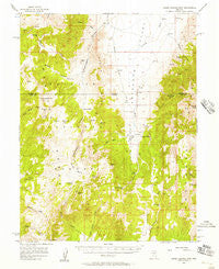
~ Horse Heaven Mtn NV topo map, 1:62500 scale, 15 X 15 Minute, Historical, 1956, updated 1957
Horse Heaven Mtn, Nevada, USGS topographic map dated 1956.
Includes geographic coordinates (latitude and longitude). This topographic map is suitable for hiking, camping, and exploring, or framing it as a wall map.
Printed on-demand using high resolution imagery, on heavy weight and acid free paper, or alternatively on a variety of synthetic materials.
Topos available on paper, Waterproof, Poly, or Tyvek. Usually shipping rolled, unless combined with other folded maps in one order.
- Product Number: USGS-5572646
- Free digital map download (high-resolution, GeoPDF): Horse Heaven Mtn, Nevada (file size: 9 MB)
- Map Size: please refer to the dimensions of the GeoPDF map above
- Weight (paper map): ca. 55 grams
- Map Type: POD USGS Topographic Map
- Map Series: HTMC
- Map Verison: Historical
- Cell ID: 55485
- Scan ID: 320990
- Imprint Year: 1957
- Woodland Tint: Yes
- Aerial Photo Year: 1954
- Field Check Year: 1956
- Datum: NAD27
- Map Projection: Polyconic
- Map published by United States Geological Survey
- Map Language: English
- Scanner Resolution: 600 dpi
- Map Cell Name: Horse Heaven Mountain
- Grid size: 15 X 15 Minute
- Date on map: 1956
- Map Scale: 1:62500
- Geographical region: Nevada, United States
Neighboring Maps:
All neighboring USGS topo maps are available for sale online at a variety of scales.
Spatial coverage:
Topo map Horse Heaven Mtn, Nevada, covers the geographical area associated the following places:
- Ryegrass Spring - Butch Spring - Mahogany Spring - Copenhagen Canyon - Foleys Spring - Quaker Spring - Segura Spring - Homestead Spring - Segura - Merriam Peak - Segura Spring Number Eight - Segura Spring Three - Sheep Spring - Blair Spring Two - Segura Spring Four - Segura Spring Number Six - Cabin Spring - Segura Spring Number Five - Segura Spring Number Seven - Whiterock Canyon - Mountain Lion Spring - Laxague Spring - Coal Burner Spring - Martin Ranch - Meadow Creek - Applebush Hill Spring - Dick Allison Spring - Allison Spring - Horse Heaven Mountain - Segura Ranch - Couger Spring - Seep Spring - Rabbit Hill - Sweeney Wash - Cabin Spring - Savory Mountain - White Rock Creek - Water Canyon Spring - Antelope Range - Ryegrass Canyon - Ninemile Peak - Ninemile Canyon - Butler Basin - Horse Heaven - Coal Burner Spring - Antelope Valley Spring - Whiterock Spring - Segura Spring - Martin Ridge
- Map Area ID: AREA39.2539-116.5-116.25
- Northwest corner Lat/Long code: USGSNW39.25-116.5
- Northeast corner Lat/Long code: USGSNE39.25-116.25
- Southwest corner Lat/Long code: USGSSW39-116.5
- Southeast corner Lat/Long code: USGSSE39-116.25
- Northern map edge Latitude: 39.25
- Southern map edge Latitude: 39
- Western map edge Longitude: -116.5
- Eastern map edge Longitude: -116.25


