
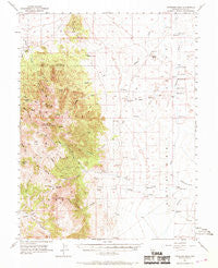
~ Antelope Peak NV topo map, 1:62500 scale, 15 X 15 Minute, Historical, 1956, updated 1969
Antelope Peak, Nevada, USGS topographic map dated 1956.
Includes geographic coordinates (latitude and longitude). This topographic map is suitable for hiking, camping, and exploring, or framing it as a wall map.
Printed on-demand using high resolution imagery, on heavy weight and acid free paper, or alternatively on a variety of synthetic materials.
Topos available on paper, Waterproof, Poly, or Tyvek. Usually shipping rolled, unless combined with other folded maps in one order.
- Product Number: USGS-5572092
- Free digital map download (high-resolution, GeoPDF): Antelope Peak, Nevada (file size: 7 MB)
- Map Size: please refer to the dimensions of the GeoPDF map above
- Weight (paper map): ca. 55 grams
- Map Type: POD USGS Topographic Map
- Map Series: HTMC
- Map Verison: Historical
- Cell ID: 50607
- Scan ID: 320670
- Imprint Year: 1969
- Woodland Tint: Yes
- Aerial Photo Year: 1954
- Field Check Year: 1956
- Datum: NAD27
- Map Projection: Polyconic
- Map published by United States Geological Survey
- Map Language: English
- Scanner Resolution: 600 dpi
- Map Cell Name: Antelope Peak
- Grid size: 15 X 15 Minute
- Date on map: 1956
- Map Scale: 1:62500
- Geographical region: Nevada, United States
Neighboring Maps:
All neighboring USGS topo maps are available for sale online at a variety of scales.
Spatial coverage:
Topo map Antelope Peak, Nevada, covers the geographical area associated the following places:
- North Fork Kelly Creek - Kitchen Meadow - Allison Creek - Faulkner Creek - Hillside Springs (historical) - Hodges Canyon - Willows Ranch - Klobe Hot Springs - Ardans Ranch - Paroni Spring - North Fork Allison Creek - Summit Mountain - Big Flat - Bradford Spring - South Fork Allison Creek - Middle Fork Allison Creek - South Fork Willow Creek - Cedar Creek - Cerruti Ranch - Bald Mountain Spring - Willow Creek - Antelope Spring - North Fork Willow Creek - Fords Ranch (historical) - Warm Spring - Sullivan Spring - Pedlar Creek - Fenstermaker Wash - Copenhagen Creek - Antelope Meadow - South Fork Pass - Allison Creek Reservoir - Antelope Valley - Cerutti Well - Sullivan Wash - Bald Mountain - Hickison Pasture - Antelope Peak - Charnac Basin - Dagget Spring - Hot Spring Ranch - Twin Spring Hills - Hot Spring Wash - Well Canyon - Morrison Ranch
- Map Area ID: AREA39.539.25-116.5-116.25
- Northwest corner Lat/Long code: USGSNW39.5-116.5
- Northeast corner Lat/Long code: USGSNE39.5-116.25
- Southwest corner Lat/Long code: USGSSW39.25-116.5
- Southeast corner Lat/Long code: USGSSE39.25-116.25
- Northern map edge Latitude: 39.5
- Southern map edge Latitude: 39.25
- Western map edge Longitude: -116.5
- Eastern map edge Longitude: -116.25


