
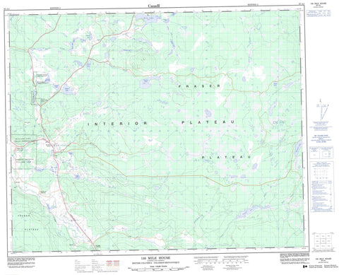
093A04 150 Mile House Canada topo map, 1:50,000 scale
093A04 150 Mile House NRCAN topographic map.
Includes UTM and GPS geographic coordinates (latitude and longitude). This 50k scale map is suitable for hiking, camping, and exploring, or you could frame it as a wall map.
Printed on-demand using high resolution, on heavy weight and acid free paper, or as an upgrade on a variety of synthetic materials.
Topos available on paper, Waterproof, Poly, or Tyvek. Usually shipping rolled, unless combined with other folded maps in one order.
- Product Number: NRCAN-093A04
- Parent Topo: TOPO-093A
- Map ID also known as: 093A04, 93A4, 93A04
- Unfolded Size: Approximately 26" high by 36" wide
- Weight (paper map): ca. 55 grams
- Map Type: POD NRCAN Topographic Map
- Map Scale: 1:50,000
- Geographical region: British Columbia, Canada
Neighboring Maps:
All neighboring Canadian topo maps are available for sale online at 1:50,000 scale.
Purchase the smaller scale map covering this area: Topo-093A
Spatial coverage:
Topo map sheet 093A04 150 Mile House covers the following places:
- Carpenter Mountain Indian Reserve 15 - Five Mile Indian Reserve 3 - James Louie Indian Reserve 3A - Réserve indienne Carpenter Mountain 15 - Réserve indienne Five Mile 3 - Réserve indienne James Louie 3A - Réserve indienne Williams Lake 1 - Williams Lake Indian Reserve 1 - Beaux Yeux Lake - Buchanan Lake - Cariboo Bill Lake - Cummings Lake - Dewar Lake - Dugan Lake - Goldpan Lake - Hansen Slough - Jones Lake - Kilgore Lake - McGuckin Lake - McIntosh Lakes - Miner Lake - Miocene Lake - Mission Ponds - O'Keefe Lake - Redeau Lake - Rose Lake - Seven Mile Lake - Spokin Lake - Squawk Lake - Twin Lake - Twin Lakes - Wheatley Lake - Yellow Lake - Cariboo Regional District - Fraser Plateau - Interior Plateau - Blue Moon Creek - Borland Creek - Bruning Creek - Bruno Creek - Bunting Creek - Coldspring Creek - Felker Creek - Five Mile Creek - Fivemile Creek - Gravel Creek - Hawks Creek - Johnny Creek - Jones Creek - Kilgore Creek - Knife Creek - Macspring Creek - Roselake Creek - San Jose River - South Hawks Creek - Twin Lake Creek - Twinlake Creek - Valley Creek - Walters Creek - Walters Creek - Watters Creek - Wheatley Creek - Wise Creek - 141 Mile House - 150 Mile House - 158 Mile House - Cariboo Indian School - Dugan Lake - Halfway House - Johnson - Miocene - Ochiltree - Onward - St. Joseph Mission - Sugarcane


