
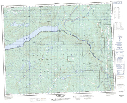
092P16 Mahood Lake Canada topo map, 1:50,000 scale
092P16 Mahood Lake NRCAN topographic map.
Includes UTM and GPS geographic coordinates (latitude and longitude). This 50k scale map is suitable for hiking, camping, and exploring, or you could frame it as a wall map.
Printed on-demand using high resolution, on heavy weight and acid free paper, or as an upgrade on a variety of synthetic materials.
Topos available on paper, Waterproof, Poly, or Tyvek. Usually shipping rolled, unless combined with other folded maps in one order.
- Product Number: NRCAN-092P16
- Parent Topo: TOPO-092P
- Map ID also known as: 092P16, 92P16
- Unfolded Size: Approximately 26" high by 36" wide
- Weight (paper map): ca. 55 grams
- Map Type: POD NRCAN Topographic Map
- Map Scale: 1:50,000
- Geographical region: British Columbia, Canada
Neighboring Maps:
All neighboring Canadian topo maps are available for sale online at 1:50,000 scale.
Purchase the smaller scale map covering this area: Topo-092P
Spatial coverage:
Topo map sheet 092P16 Mahood Lake covers the following places:
- Dawson Falls - Deception Falls - Goodwin Falls - Helmcken Falls - McDiarmid Falls - Moul Falls - Sylvia Falls - Constance Lake - Corsica Lake - Cougar Lake - Efdee Lake - Ejas Lake - Foot Lake - Italia Lake - Johnston Lake - Jonah Lake - Mahood Lake - Maury Lake - Moira Lake - Patricia Lake - Pendleton Lakes - Placid Lake - Sicily Lake - Sock Lake - Green Mountain - Green Mountains - Lizard Head Mountain - Mount Mahood - Pyramid Mountain - Quesnel Highland - Shuswap Highland - Swayback Ridge - White Horse Bluff - Cariboo Regional District - Wellesley Gray Recreation Area - Wells Gray Park - Wells Gray Recreation Area - Fraser Plateau - Interior Plateau - Batholith Rapids - Sabre Tooth Rapids - The Mushbowl - Aqua Creek - Battle Creek - Blackwater Creek - Byrd Creek - Canimred Creek - Case Creek - Clearwater River - Clover Creek - Deception Creek - Duncan Creek - Fage Creek - First Canyon Creek - Flourmill Creek - Garter Creek - Grouse (Moul) Creek - Hemp Creek - Mahood River - Mann Creek - Moul Creek - Murtle River - Ordschig Creek - Philip Creek - Second Canyon Creek - Shook Brook - Spanish Creek - Third Canyon Creek - Trout Creek - Helmcken Canyon


