
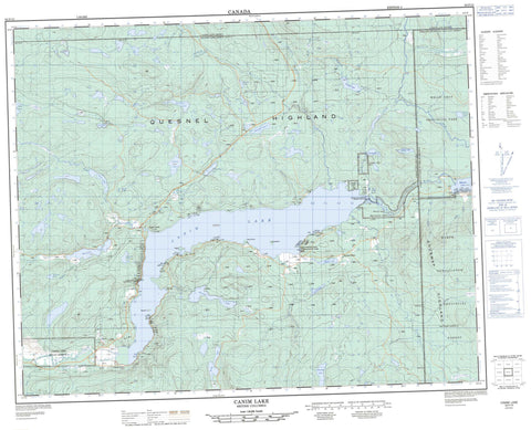
092P15 Canim Lake Canada topo map, 1:50,000 scale
092P15 Canim Lake NRCAN topographic map.
Includes UTM and GPS geographic coordinates (latitude and longitude). This 50k scale map is suitable for hiking, camping, and exploring, or you could frame it as a wall map.
Printed on-demand using high resolution, on heavy weight and acid free paper, or as an upgrade on a variety of synthetic materials.
Topos available on paper, Waterproof, Poly, or Tyvek. Usually shipping rolled, unless combined with other folded maps in one order.
- Product Number: NRCAN-092P15
- Parent Topo: TOPO-092P
- Map ID also known as: 092P15, 92P15
- Unfolded Size: Approximately 26" high by 36" wide
- Weight (paper map): ca. 55 grams
- Map Type: POD NRCAN Topographic Map
- Map Scale: 1:50,000
- Geographical region: British Columbia, Canada
Neighboring Maps:
All neighboring Canadian topo maps are available for sale online at 1:50,000 scale.
Purchase the smaller scale map covering this area: Topo-092P
Spatial coverage:
Topo map sheet 092P15 Canim Lake covers the following places:
- Paul Point - Canim Falls - Canim Lake Indian Reserve 1 - Canim Lake Indian Reserve 5 - Canim Lake Indian Reserve 6 - Réserve indienne Canim Lake 1 - Réserve indienne Canim Lake 5 - Réserve indienne Canim Lake 6 - Canoe Island - Eagle Island - Round Island - Baldwin Lake - Beartrack Lake - Beaver Lake - Bobbs Lake - Boomerang Lake - Canim Lake - Chautemps Lake - Chris Lake - Christmas Lake - Christopher Lake - Donnely Lake - Greenlee Lake - Hawkins Lake - Hotfish Lake - Howard Lake - Judy Lake - Kellington Lake - Lang Lake - Lorin Lake - Mahood Lake - McNeil Lake - Roger Lake - Roserim Lake - Schoolhouse Lake - Squirrel Lake - Streak Lake - Succour Lake - Susan Lake - Thomson Lake - Tiny Tim Lake - Tommy Archie Lake - Weller Lake - Whale Lake - Wolf Lake - Mount Ryan - Quesnel Highland - Shuswap Highland - Cariboo Regional District - Canim Beach Park - Lang Lake/Schoolhouse Park - Roserim Creek Park - Schoolhouse Lake Park - Wells Gray Park - Fraser Plateau - Interior Plateau - Art Creek - Bobbs Creek - Boss Creek - Bradley Creek - Bridge Creek - Bridge Creek - Burtt Creek - Canim Creek - Canim River - Canimred Creek - Chautemps Creek - Christmas Creek - Dan MacKay Creek - Deception Creek - Devils Club Creek - Eagle Creek - Fern Creek - Hendrix (Martin) Creek - Hendrix Creek - Hotfish Creek - Jackrabbit Creek - Jim Creek - Lutely Creek - Martin Creek - Meekers Creek - Neff Creek - Roserim Creek - Spanish Creek - Squirrel Creek - Succour Creek - Terraced Creek - Thomson Creek - Webb Creek - Weller Creek - Willowswamp Creek - Canim Lake - Eagle Creek - Mahood Falls


