
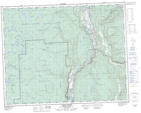
092P01 Louis Creek Canada topo map, 1:50,000 scale
092P01 Louis Creek NRCAN topographic map.
Includes UTM and GPS geographic coordinates (latitude and longitude). This 50k scale map is suitable for hiking, camping, and exploring, or you could frame it as a wall map.
Printed on-demand using high resolution, on heavy weight and acid free paper, or as an upgrade on a variety of synthetic materials.
Topos available on paper, Waterproof, Poly, or Tyvek. Usually shipping rolled, unless combined with other folded maps in one order.
- Product Number: NRCAN-092P01
- Parent Topo: TOPO-092P
- Map ID also known as: 092P01, 92P1, 92P01
- Unfolded Size: Approximately 26" high by 36" wide
- Weight (paper map): ca. 55 grams
- Map Type: POD NRCAN Topographic Map
- Map Scale: 1:50,000
- Geographical region: British Columbia, Canada
Neighboring Maps:
All neighboring Canadian topo maps are available for sale online at 1:50,000 scale.
Purchase the smaller scale map covering this area: Topo-092P
Spatial coverage:
Topo map sheet 092P01 Louis Creek covers the following places:
- Barriere - Barriere River Indian Reserve 3A - Kamloops Indian Reserve 4 - Louis Creek Indian Reserve 4 - North Thompson Indian Reserve 1 - Réserve indienne Barriere River 3A - Réserve indienne Kamloops 4 - Réserve indienne Louis Creek 4 - Réserve indienne North Thompson 1 - Réserve indienne Whispering Pines 4 - Whispering Pines Indian Reserve 4 - Gilead Island - Adler Lake - Allan Lake - Badger Lake - Beauregard Lake - Black Lake - Bob Creek - Bob Lake - Bogmar Lake - Boulanger Lake - Camp Nine Lake - Cannine Lake - Caribou Lake - Couture Lake - Coyote Lake - Dagger Lake - Dewey Lake - Dumbell Lake - Dunsapie Lake - Estelle Lake - Frankie Lake - Frogpond Lake - Genier Lakes - Gorman Lake - Grant Lake - Hoopatatkwa Lake - Hoover Lake - Little Badger Lake - Lloyd Lake - Martha Lake - Martin Meadows Lake - Mayson Lake - Meighan Lakes - Mollimarn Lake - Norma Lake - Osprey Lake - Parky Lake - Pinerock Lake - Pothole Lake - Rea Lake - Renee Lake - Rexford Lake - Rock Island Lake - Rushton Slough - Shelley Lake - Siam Lake - Spooney Lake - Spooney Lakes - Struthers Lakes - Stuart Lake - Totunkwa Lake - Tsintsunko Lake - Tuwut Lake - Twin Lake - Whitewood Lake - Willowgrouse Lake - Windy Lake - Barrière Mountain - Barriere Mountains - Dixon Mountains - Dixon Ridge - Edwards Mountains - Fishtrap Mountain - Garrison Mountain - Genier Hill - Goudreau Mountains - Jamieson Range - Metoots Hill - Mount Armour - Mount Borthwick - Mount Dixon - Mount Edwards - Mount Fraser - Mount Goudreau - Mount Hagen - Mount McGregor - Parky Mountain - Poison Hill - Shuswap Highland - Skoatl Point - Skull Hill - Thompson-Nicola Regional District - Bonaparte Park - Tsintsunko Lakes Park - Fraser Plateau - Gizzard Flats - Interior Plateau - Thompson Plateau - Fishtrap Rapids - Badger Creek - Barlett Creek - Barriere River - Barrière River - Bonaparte River - Bottrel Creek - Bridge Creek - Camp Nine Creek - Champ Creek - Deadman River - Dixon Creek - Fadear Creek - Fishtrap Creek - Forster Creek - Fraser Creek - Jamieson Creek - Jet Creek - Leonie Creek - Louis Creek - Mystery Creek - Nanak Creek - Nelson Creek - Noble Creek - North Thompson River - Oliver Creek - Parky Creek - Peterson Creek - Poison Creek - Sargent Creek - Sargent Creek - Skull Creek - Struthers Creek - Stuart Creek - Whitewood Creek - William Creek - Barrière - Blucher Hall - Chinook Cove - Exlou - Louis Creek - McLure


