
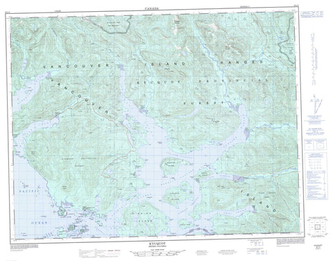
092L03 Kyuquot Canada topo map, 1:50,000 scale
092L03 Kyuquot NRCAN topographic map.
Includes UTM and GPS geographic coordinates (latitude and longitude). This 50k scale map is suitable for hiking, camping, and exploring, or you could frame it as a wall map.
Printed on-demand using high resolution, on heavy weight and acid free paper, or as an upgrade on a variety of synthetic materials.
Topos available on paper, Waterproof, Poly, or Tyvek. Usually shipping rolled, unless combined with other folded maps in one order.
- Product Number: NRCAN-092L03
- Parent Topo: TOPO-092L
- Map ID also known as: 092L03, 92L3, 92L03
- Unfolded Size: Approximately 26" high by 36" wide
- Weight (paper map): ca. 55 grams
- Map Type: POD NRCAN Topographic Map
- Map Scale: 1:50,000
- Geographical region: British Columbia, Canada
Neighboring Maps:
All neighboring Canadian topo maps are available for sale online at 1:50,000 scale.
Purchase the smaller scale map covering this area: Topo-092L
Spatial coverage:
Topo map sheet 092L03 Kyuquot covers the following places:
- Amai Inlet - Barter Cove - Cachalot Inlet - Centre Cove - Chamiss Bay - Clanninick Cove - Dixie Cove - Easy Inlet - Fair Harbour - Hankin Cove - Jansen Bay - Kamils Anchorage - Kashutl Inlet - Kokshittle Arm - Malksope Inlet - McKay Cove - Monteith Bay - Ououkinsh Inlet - Tahsish Arm - Tahsish Inlet - Walters Cove - Werner Bay - Wood Cove - Yaku Bay - Amai Point - Balcom Point - Chamiss Point - Chatchannel Point - Guillod Point - Hohoae Point - Machta Point - Malksope Point - Markale Peninsula - Markale Point - McGrath Point - McLean Point - Moketas Point - Unsworth Point - Upsowis Point - Village Point - Brown Channel - Crowther Channel - Eelstow Passage - Kyuquot Channel - Kyuquot Sound - Markale Passage - Nicolaye Channel - Pinnace Channel - Kayouk Bluff - Trapp Bluff - Ahmacinnit Indian Reserve 3 - Amai Indian Reserve 15 - Artlish Indian Reserve 12 - Chamiss Indian Reserve 7 - Granite Island Indian Reserve 4 - Hisnit Indian Reserve 4 - Houpsitas Indian Reserve 6 - Kaoowinch Indian Reserve 10 - Kaouk Indian Reserve 13 - Kashittle Indian Reserve 9 - Kayouk Indian Reserve 8 - Machta Indian Reserve 16 - Malksope Indian Reserve 7 - Markale Indian Reserve 14 - Mission Island Indian Reserve 2 - Ououkinsh Indian Reserve 5 - Réserve indienne Ahmacinnit 3 - Réserve indienne Amai 15 - Réserve indienne Artlish 12 - Réserve indienne Chamiss 7 - Réserve indienne Granite Island 4 - Réserve indienne Hisnit 4 - Réserve indienne Houpsitas 6 - Réserve indienne Kaoowinch 10 - Réserve indienne Kaouk 13 - Réserve indienne Kashittle 9 - Réserve indienne Kayouk 8 - Réserve indienne Machta 16 - Réserve indienne Malksope 7 - Réserve indienne Markale 14 - Réserve indienne Mission Island 2 - Réserve indienne Ououkinsh 5 - Réserve indienne Tahsish 11 - Réserve indienne Upsowis 6 - Réserve indienne Village Island 1 - Réserve indienne Yakats 5 - Tahsish Indian Reserve 11 - Upsowis Indian Reserve 6 - Village Island Indian Reserve 1 - Yakats Indian Reserve 5 - Ahmacinnit Island - Aktis Island - Amos Island - Barrier Islands - Bunsby Islands - Christine Island - Chutsis Island - Copp Island - Expedition Islets - Hisnit Islands - Hohoae Island - Île de Vancouver - Kamils Island - Karouk Island - Kon Tiki Island - Lookout Island - McLean Island - Meyer Island - Mission Group - Mission Islands - Moketas Island - Okime Island - Rolston Island - Sobry Island - Spring Island - Surprise Island - Thomas Island - Tree Island - Union Island - Vancouver Island - Walters Island - Whiteley Island - Jansen Lake - Power Lake - Silburn Lake - Soatwoon Lake - Union Lake - Welch Lakes - False Ears - Family Humps - Garibaldi Peaks - Harold Hill - Mount Paxton - Mount Renwick - Slate Mountain - Snow Saddle Mountain - Snowsaddle Mountain - St. Pauls Dome - Vancouver Island Mountains - Vancouver Island Ranges - Regional District of Comox-Strathcona - Regional District of Mount Waddington - Dixie Cove Marine Park - Dixie Cove Park - Tahsish-Kwois Park - Amai Creek - Artlish River - British Creek - Chamiss Creek - Clanninick Creek - Kaouk River - Kashutl River - Kauwinch River - Kauwinch River - Kayouk Creek - Kwois Creek - Malksope River - Marble River - Ououkinsh River - Power River - Soatwoon Creek - St. Pauls Dome Creek - Tahsish River - Traill Creek - Channel Rock - Channel Rocks - Chief Rock - Cole Rock - Gayward Rock - Louise Rock - Minx Rocks - Warren Rocks - Yakats Rock - Amai Creek - Chamiss Bay - Fair Harbour - Kyuquot


