
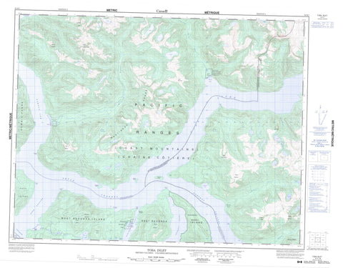
092K07 Toba Inlet Canada topo map, 1:50,000 scale
092K07 Toba Inlet NRCAN topographic map.
Includes UTM and GPS geographic coordinates (latitude and longitude). This 50k scale map is suitable for hiking, camping, and exploring, or you could frame it as a wall map.
Printed on-demand using high resolution, on heavy weight and acid free paper, or as an upgrade on a variety of synthetic materials.
Topos available on paper, Waterproof, Poly, or Tyvek. Usually shipping rolled, unless combined with other folded maps in one order.
- Product Number: NRCAN-092K07
- Parent Topo: TOPO-092K
- Map ID also known as: 092K07, 92K7, 92K07
- Unfolded Size: Approximately 26" high by 36" wide
- Weight (paper map): ca. 55 grams
- Map Type: POD NRCAN Topographic Map
- Map Scale: 1:50,000
- Geographical region: British Columbia, Canada
Neighboring Maps:
All neighboring Canadian topo maps are available for sale online at 1:50,000 scale.
Purchase the smaller scale map covering this area: Topo-092K
Spatial coverage:
Topo map sheet 092K07 Toba Inlet covers the following places:
- Attwood Bay - Brem Bay - Doctor Bay - Pendrell Sound - Quatam Bay - Ramsay Arm - Redonda Bay - Toba Inlet - Walsh Cove - Bluff Point - Brettell Point - Butler Point - Connis Point - Dean Point - Foster Point - George Head - George Point - George Point - Gloucester Point - Hepburn Point - Kate Point - Millerd Point - Snout Point - Tibbs Point - Deer Passage - False Passage - Homfray Channel - Pryce Channel - Raza Passage - Deep Valley Indian Reserve 5 - Réserve indienne Deep Valley 5 - Réserve indienne Salmon Bay 3 - Réserve indienne Siakin 4 - Salmon Bay Indian Reserve 3 - Siakin Indian Reserve 4 - Channel Island - Double Island - East Redonda Island - Elizabeth Island - Gorges Islands - Raza Island - Redonda Islands - West Redonda Island - Baile Lake - Derwent Lake - Homfray Lake - Joe Lake - Tom Lake - Chaîne Côtière - Coast Mountains - Downie Range - Face Mountain - Gastineau Mountains - Gastineau Range - Gloucester Mountain - Hat Mountain - Mount Aiken - Mount Barner - Mount Bunsen - Mount Denman - Mount Doogie Dowler - Mount Eliza - Mount Grazebrooke - Mount Hayes - Mount Monk - Mount Perritt - Mount Powell - Mount Whieldon - Pacific Ranges - Regional District of Comox-Strathcona - Walsh Cove Park - Alpine Creek - Berg Creek - Brem River - Clipper Creek - Georgie River - Hillis Creek - Homfray Creek - Lillian Russell Creek - Quatam River - Racine Creek - Tzela Creek - Dean Rock - Deceit Rock - Brem River - Homfray Creek - Redonda Bay


