
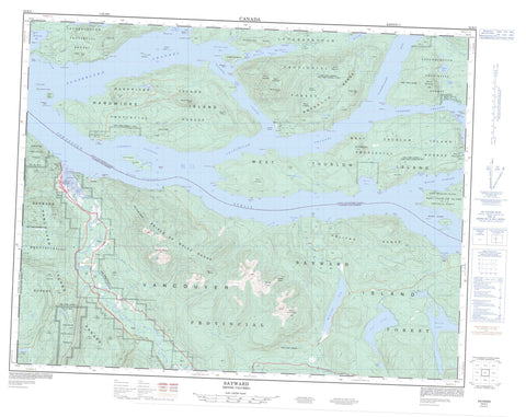
092K05 Sayward Canada topo map, 1:50,000 scale
092K05 Sayward NRCAN topographic map.
Includes UTM and GPS geographic coordinates (latitude and longitude). This 50k scale map is suitable for hiking, camping, and exploring, or you could frame it as a wall map.
Printed on-demand using high resolution, on heavy weight and acid free paper, or as an upgrade on a variety of synthetic materials.
Topos available on paper, Waterproof, Poly, or Tyvek. Usually shipping rolled, unless combined with other folded maps in one order.
- Product Number: NRCAN-092K05
- Parent Topo: TOPO-092K
- Map ID also known as: 092K05, 92K5, 92K05
- Unfolded Size: Approximately 26" high by 36" wide
- Weight (paper map): ca. 55 grams
- Map Type: POD NRCAN Topographic Map
- Map Scale: 1:50,000
- Geographical region: British Columbia, Canada
Neighboring Maps:
All neighboring Canadian topo maps are available for sale online at 1:50,000 scale.
Purchase the smaller scale map covering this area: Topo-092K
Spatial coverage:
Topo map sheet 092K05 Sayward covers the following places:
- Bear Bight - Beaver Inlet - Bendickson Harbour - Bessborough Bay - Billygoat Bay - Blenkinsop Bay - Blinkinsop Bay - Brasseau Bay - Butterfly Bay - Douglas Bay - Forward Harbour - Hkusam Bay - Humpback Bay - Kelsey Bay - Knox Bay - Little Bear Bay - Loughborough Inlet - McLeod Bay - Nichols Bay - Palmer Bay - Salmon Bay - Topaze Harbour - Vere Cove - Althorp Point - Bear Point - Blanche Point - Camp Point - Carterer Point - Cust Point - D'Arcy Point - Dennie Point - Eden Point - Edith Point - Edward Point - Fittleton Point - Florence Point - Geneste Point - Graveyard Point - Greene Point - Grismond Point - Gunner Point - Hardwicke Point - Horace Point - Louis Point - Louisa Point - Margaret Point - Maud Point - Mayne Point - Needham Point - Point Tuna - Ripple Point - Robson Point - Rock Point - Scottys Point - Shaw Point - Shorter Point - Styles Point - Termagant Point - Thynne Peninsula - Thynne Point - Tucker Point - Tuna Point - Tyee Point - Vansittart Point - Chancellor Channel - Cordero Channel - Current Passage - Johnstone Strait - Mayne Passage - Race Passage - Sunderland Channel - Wellbore Channel - Pembroke Range - Matlaten Indian Reserve 4 - Réserve indienne Matlaten 4 - Réserve indienne Salmon River 1 - Salmon River Indian Reserve 1 - Artillery Islets - Black Island - Bulkely Island - Clarence Island - Cordero Islands - East Thurlow Island - Fanny Island - Griffiths Island - Griffiths Islet - Hardwicke Island - Helmcken Island - Île de Vancouver - Lyall Island - Mary Island - Midgham Islet - Midgham Islets - Murray Island - Peterson Islet - Poyntz Island - Seymour Island - Thurlow Islands - Vancouver Island - Walkem Islands - West Thurlow Island - Yorke Island - Alpheus Lake - Audrey Lake - Lihou Lake - Lower Stella Lake - Mackie Lake - McCreight Lake - Pye Lake - Santa Maria Lake - Seabird Lake - Stella Lake - Sunday Lake - Tlowils Lake - Woolloomooloo Lake - Wooloomooloo Lake - Craven Hill - Franklin Range - Franklyn Range - Halifax Range - High Rigger - Hkusam Mountain - Knox Hill - Mount Bradshaw - Mount Clarence - Mount Egremont - Mount Frederick - Mount George - Mount Harewood - Mount Hkusam - Mount Kitchener - Mount Lascelles - Mount Milner - Mount Roberts - Mount Royston - Mount Vansittart - Mount Yorke - Needle Peaks - Paget Cone - Prince of Wales Range - Solitary Mountain - Sparks Cone - Town Hill - Tripp Hill - Valley Cone - Vancouver Island Mountains - Vancouver Island Ranges - Wharncliffe Range - Regional District of Comox-Strathcona - Regional District of Mount Waddington - Amor de Cosmos Creek - Amor De Cosmos Creek - Bigtree Creek - Browning Creek - Dalrymple Creek - Elk Creek - Fagan Creek - Galvani Creek - Gauvin Creek - Hamersley Creek - Pye Creek - Roberts Creek - Salmon River - South Elk Creek - Springer Creek - Stowe Creek - Sunday Creek - Tuna River - White River - Wortley Creek - Greene Point Rapids - Whirlpool Rapids - Dickson Shoal - Dorothy Rock - Earl Ledge - Ivanhoe Rock - Ripple Shoal - Speaker Rock - Blind Channel - Hardwicke Island - Hkusam - Kelsey Bay - Sayward


