
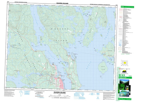
092K03 Quadra Island Canada topo map, 1:50,000 scale
092K03 Quadra Island NRCAN topographic map.
Includes UTM and GPS geographic coordinates (latitude and longitude). This 50k scale map is suitable for hiking, camping, and exploring, or you could frame it as a wall map.
Printed on-demand using high resolution, on heavy weight and acid free paper, or as an upgrade on a variety of synthetic materials.
Topos available on paper, Waterproof, Poly, or Tyvek. Usually shipping rolled, unless combined with other folded maps in one order.
- Product Number: NRCAN-092K03
- Parent Topo: TOPO-092K
- Map ID also known as: 092K03, 92K3, 92K03
- Unfolded Size: Approximately 26" high by 36" wide
- Weight (paper map): ca. 55 grams
- Map Type: POD NRCAN Topographic Map
- Map Scale: 1:50,000
- Geographical region: British Columbia, Canada
Neighboring Maps:
All neighboring Canadian topo maps are available for sale online at 1:50,000 scale.
Purchase the smaller scale map covering this area: Topo-092K
Spatial coverage:
Topo map sheet 092K03 Quadra Island covers the following places:
- Bird Cove - Brown Bay - Burdwood Bay - Carrington Bay - Conville Bay - Coulter Bay - Deepwater Bay - Drew Harbour - Duncan Bay - Evans Bay - Gorge Harbour - Gowlland Harbour - Granite Bay - Heriot Bay - Hjorth Bay - Hoskyn Inlet - Hyacinthe Bay - Kanish Bay - Lake Bay - Loveland Bay - McIvor Lake - Menzies Bay - Moulds Bay - Nymphe Cove - Open Bay - Plumper Bay - Quartz Bay - Quathiaski Cove - Totem Bay - Twin Bay - Unkak Cove - Village Bay - Whaletown Bay - Yeatman Bay - Antonio Point - April Point - Bodega Point - Bold Point - Conville Point - Dunsterville Point - Francisco Point - Frederic Point - Huntingford Point - Hyacinthe Point - McMullen Point - Middle Point - Orange Point - Plumper Point - Race Point - Read Point - Rebecca Spit - Separation Head - Shark Spit - Sheer Point - Stephenson Point - Surge Point - Tyee Spit - Viner Point - Wilfred Point - Beazley Passage - Crescent Channel - Discovery Passage - Hoskyn Channel - Okisollo Channel - Plunger Passage - Seymour Narrows - Surge Narrows - Sutil Channel - The Gorge - Uganda Passage - Whale Passage - Whiterock Passage - Campbell River - Bullock Bluff - Copper Cliffs - North Bluff - Puget Bluff - Deer Falls - Elk Falls - Moose Falls - Comox Land District - Sayward Land District - Campbell River Indian Reserve 11 - Cape Mudge Indian Reserve 10 - Drew Harbour Indian Reserve 9 - Open Bay Indian Reserve 8 - Quinsam Indian Reserve 12 - Réserve indienne Campbell River 11 - Réserve indienne Cape Mudge 10 - Réserve indienne Drew Harbour 9 - Réserve indienne Open Bay 8 - Réserve indienne Quinsam 12 - Réserve indienne Tatpo-oose 10 - Réserve indienne Village Bay 7 - Tatpo-oose Indian Reserve 10 - Village Bay Indian Reserve 7 - Bee Islets - Bold Island - Breton Islands - Brown Island - Centre Islet - Chain Islands - Chained Islands - Cortes Island - Coulter Island - Crow Islet - Deadman Island - Doe Islet - Dunsterville Islet - Fawn Islet - Goepel Island - Gowlland Island - Grouse Island - Guide Islets - Heather Islets - Heriot Island - Hill Island - Île de Vancouver - Jane Island - Jane Islet - King Islets - Marina Island - Maud Island - Maurelle Island - May Island - Mouse Islets - Peck Island - Penn Islands - Quadra Island - Read Island - Settlers Group - Settlers Group Islands - Stag Island - Steep Island - Stove Islet - Stove Islets - Sturt Island - Subtle Islands - Tan Island - Tide Islet - Vancouver Island - Vigilant Islets - Welsford Islands - Wesley Island - Wren Islet - Yellow Island - Baikie Slough - Campbell Lake - Clear Lake - Crane Lake - Darkwater Lake - Gosling Lake - Jasper Lake - John Hart Lake - Kelly Lake - Little Lake - Little Main Lake - Lost Lake - Main Lake - Mary Lake - Mohun Lake - Morte Lake - Morton Lake - Newton Lake - Nugedzi Lake - Rosen Lake - Saltwater Lagoon - Saxon Lake - September Lake - Stramberg Lake - Village Bay Lake - Evening Mountain - Mount Lolo - Mount Menzies - Mount Seymour - Mount William - Regional District of Comox-Strathcona - Strathcona Regional District - Blenkin Memorial Park - Elk Falls Park - Loveland Bay Park - Loveland Bay Recreation Area - Main Lake Park - Main Lakes Chain Park - Morton Lake Park - Read Island Park - Rebecca Spit Marine Park - Rebecca Spit Park - Small Inlet Marine Park - Surge Narrows Park - Josephine Flat - Barron Creek - Bennett Creek - Campbell River - Canyon Creek - Casey Creek - Clear Creek - Drew Creek - Flintoff Creek - Haig-Brown Kingfisher Creek - Luoma Creek - McKercher Creek - Menzies Creek - Mohun Creek - Mohun River - Nunns Creek - Pidcock Creek - Quinsam River - SaxonCreek - Shadow Brook - Snowdon Creek - Stramberg Creek - Unkak Creek - Welch Creek - Defender Shoal - Entrance Bank - Entrance Rock - Hoskyn Rock - Marina Reef - Ripple Rock - Spoil Rock - Tusko Rock - Warspite Rock - Yaculta Bank - Bloedel - Bold Point - Campbellton - Duncan Bay - Granite Bay - Heriot Bay - North Campbell River - Quathiaski Cove - Quinsam - Read Island - Surge Narrows - Whaletown - Yaculta


