
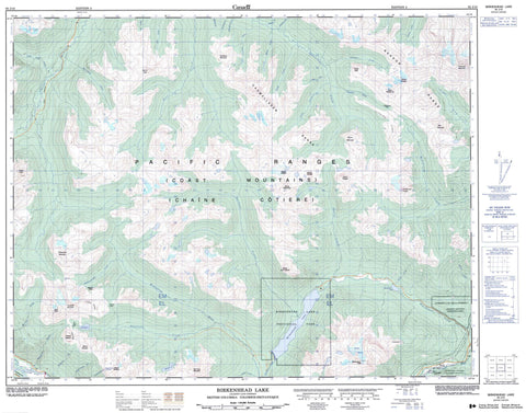
092J10 Birkenhead Lake Canada topo map, 1:50,000 scale
092J10 Birkenhead Lake NRCAN topographic map.
Includes UTM and GPS geographic coordinates (latitude and longitude). This 50k scale map is suitable for hiking, camping, and exploring, or you could frame it as a wall map.
Printed on-demand using high resolution, on heavy weight and acid free paper, or as an upgrade on a variety of synthetic materials.
Topos available on paper, Waterproof, Poly, or Tyvek. Usually shipping rolled, unless combined with other folded maps in one order.
- Product Number: NRCAN-092J10
- Parent Topo: TOPO-092J
- Map ID also known as: 092J10, 92J10
- Unfolded Size: Approximately 26" high by 36" wide
- Weight (paper map): ca. 55 grams
- Map Type: POD NRCAN Topographic Map
- Map Scale: 1:50,000
- Geographical region: British Columbia, Canada
Neighboring Maps:
All neighboring Canadian topo maps are available for sale online at 1:50,000 scale.
Purchase the smaller scale map covering this area: Topo-092J
Spatial coverage:
Topo map sheet 092J10 Birkenhead Lake covers the following places:
- Birken Glacier - Bluevault Glacier - Anderson Lake Indian Reserve 5 - Nequatque Indian Reserve 4 - Réserve indienne Anderson Lake 5 - Réserve indienne Nequatque 4 - Birkenhead Lake - Blackwater Lake - Cerulean Lake - Gingerbread Lake - Grouty Peak - Gwyneth Lake - Lajoie Lake - McDonald Lake - Noel Lake - Opal Lake - Pearson Pond - Plateau Ponds - Tenquille Lake - Bendor Range - Birkenhead Peak - Cadwallader Range - Cayoosh Range - Chaîne Côtière - Chipmunk Mountain - Coast Mountains - Copper Mound - Finch Ridge - Goat Peak - McGillivray Mountain - Mount Aragorn - Mount Barbour - Mount Gandalf - Mount Gandalf - Mount John Decker - Mount McDonald - Mount McGillivray - Mount McLeod - Mount Noel - Mount Piebiter - Mount Shadowfax - Mount Shadowfax - Mount Taillefer - Mount Weart - Mount Weinhold - Noel Mountain - Pacific Ranges - Prospector Peaks - Royal Peak - Standard Ridge - Star Mountain - Sun God Mountain - Sunshine Mountain - Tenquille Mountain - Wedge Mountain - Whitecap Mountain - Squamish-Lillooet Regional District - Birkenhead Lake Park - Mowich Flats - Aggie Creek - Blackbird Creek - Blackwater Creek - Cadwallader Creek - Capricorn Creek - Carl Creek - Chism Creek - Connel Creek - Copp Creek - Crazy Creek - D'Arcy Creek - Extension Creek - Freiberg Creek - Gates River - Gingerbread Creek - Gwyneth Creek - Hawthorn Creek - Headquarters Creek - Hope Creek - Hurley River - Johnny Sandy Creek - Lajoie Creek - Lillooet River - Lone Goat Creek - Mason Creek - McDonald Creek - McGillivray Creek - McKinley Creek - Mowich Creek - Noel Creek - Pearson Creek - Phelix Creek - Piebiter Creek - Plutus Creek - Poole Creek - President Creek - Scout Creek - Sockeye Creek - Standard Creek - Steep Creek - Taillefer Creek - Tenas Creek - Tenquille Creek - Thomson Creek - Tommy Creek - Twinturn Creek - Walker Creek - Waterfalls Creek - Gates - Fossil Pass - Grizzly Pass - McGillivray Pass - Pemberton Valley - Tenquille Pass


