
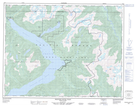
092J04 Princes Louisa Inlet Canada topo map, 1:50,000 scale
092J04 Princes Louisa Inlet NRCAN topographic map.
Includes UTM and GPS geographic coordinates (latitude and longitude). This 50k scale map is suitable for hiking, camping, and exploring, or you could frame it as a wall map.
Printed on-demand using high resolution, on heavy weight and acid free paper, or as an upgrade on a variety of synthetic materials.
Topos available on paper, Waterproof, Poly, or Tyvek. Usually shipping rolled, unless combined with other folded maps in one order.
- Product Number: NRCAN-092J04
- Parent Topo: TOPO-092J
- Map ID also known as: 092J04, 92J4, 92J04
- Unfolded Size: Approximately 26" high by 36" wide
- Weight (paper map): ca. 55 grams
- Map Type: POD NRCAN Topographic Map
- Map Scale: 1:50,000
- Geographical region: British Columbia, Canada
Neighboring Maps:
All neighboring Canadian topo maps are available for sale online at 1:50,000 scale.
Purchase the smaller scale map covering this area: Topo-092J
Spatial coverage:
Topo map sheet 092J04 Princes Louisa Inlet covers the following places:
- Deserted Bay - Jervis Inlet - Princess Louisa Inlet - Patrick Point - Chatterbox Falls - Pemberton Icefield - Chelohsin Indian Reserve 13 - Hunaechin Indian Reserve 11 - Paykulkum Indian Reserve 14 - Réserve indienne Chelohsin 13 - Réserve indienne Hunaechin 11 - Réserve indienne Paykulkum 14 - Réserve indienne Swaywelat 12 - Réserve indienne Swaywelat 12A - Réserve indienne Tsooahdie 15 - Swaywelat Indian Reserve 12 - Swaywelat Indian Reserve 12A - Tsooahdie Indian Reserve 15 - Hamilton Island - Macdonald Island - Malibu Islet - McCannel Lake - Rugged Lake - Ashlu Mountain - Chaîne Côtière - Coast Mountains - Mount Albert - Mount Arthur - Mount Crerar - Mount Frederick William - Mount Helena - Mount Pearkes - Mount Victoria - Mount Wellington - Pacific Ranges - Porterhouse Peak - Sunshine Coast Regional District - Chelohsin SB 13 - Hunaechin SB 11 - Paykulkum SB 14 - Swaywelat SB 12 - Swaywelat SB 12A - Tsooahdie SB 15 - Princess Louisa Marine Park - Princess Louisa Park - Malibu Rapids - Alfred Creek - Ashlu Creek - Crabapple Creek - Deserted River - Elaho River - Glacial Creek - Helena Creek - Hunaechin Creek - Lausmann Creek - Loquilts Creek - Osgood Creek - Potato Creek - Seavey Creek - Seshal Creek - Shortcut Creek - Skwawka River - Slane Creek - Smanit Creek - Stakawus Creek - Tsuahdi Creek - Princess Royal Reach - Queens Reach - Hill Rock - Malibu - Princess Louisa Inlet - Sechelt Indian Government District


