
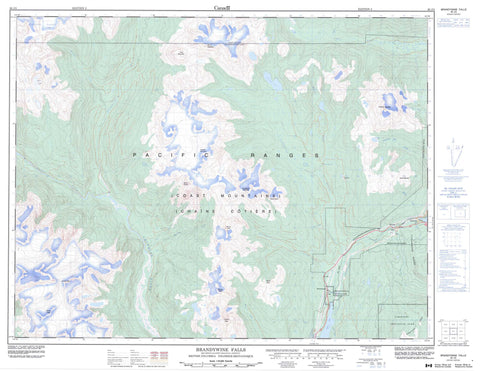
092J03 Brandywine Falls Canada topo map, 1:50,000 scale
092J03 Brandywine Falls NRCAN topographic map.
Includes UTM and GPS geographic coordinates (latitude and longitude). This 50k scale map is suitable for hiking, camping, and exploring, or you could frame it as a wall map.
Printed on-demand using high resolution, on heavy weight and acid free paper, or as an upgrade on a variety of synthetic materials.
Topos available on paper, Waterproof, Poly, or Tyvek. Usually shipping rolled, unless combined with other folded maps in one order.
- Product Number: NRCAN-092J03
- Parent Topo: TOPO-092J
- Map ID also known as: 092J03, 92J3, 92J03
- Unfolded Size: Approximately 26" high by 36" wide
- Weight (paper map): ca. 55 grams
- Map Type: POD NRCAN Topographic Map
- Map Scale: 1:50,000
- Geographical region: British Columbia, Canada
Neighboring Maps:
All neighboring Canadian topo maps are available for sale online at 1:50,000 scale.
Purchase the smaller scale map covering this area: Topo-092J
Spatial coverage:
Topo map sheet 092J03 Brandywine Falls covers the following places:
- Alexander Falls - Brandywine Falls - Pemberton Icefield - Alpha Lake - Blanca Lake - Brew Lake - Callaghan Lake - Daisy Lake - Pinecrest Lake - Powell Lake - Rainbow Lake - Ransom Lake - Retta Lake - Wood Lake - Brandywine Mountain - Chaîne Côtière - Coast Mountains - Cypress Peak - Empetrum Ridge - Fitzsimmons Range - Icecap Peak - Metal Dome - Mount Brew - Mount Callaghan - Mount Cayley - Mount Fee - Mount Sproatt - Pacific Ranges - Powder Mountain - Pykett Peak - Rainbow Mountain - Ring Mountain - Tricouni Peak - Brandywine Falls Park - Callaghan Lake Park - Garibaldi Park - Alpha Creek - Brandywine Creek - Brew Creek - Callaghan Creek - Dipper Creek - Dority Creek - Edna Creek - Elaho River - Madeley Creek - Marble Creek - Millar Creek - Nineteen Mile Creek - Petticoat Creek - Roe Creek - Shovelnose Creek - Snow Creek - Soo River - Sproatt Creek - Squamish River - Torrent Creek - Turbid Creek - Twentyone Mile Creek - Brandywine - Brandywine Falls - McGuire - Sproatt - Tamarisk - Van West - Water Tank


