
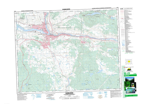
092I09 Kamloops Canada topo map, 1:50,000 scale
092I09 Kamloops NRCAN topographic map.
Includes UTM and GPS geographic coordinates (latitude and longitude). This 50k scale map is suitable for hiking, camping, and exploring, or you could frame it as a wall map.
Printed on-demand using high resolution, on heavy weight and acid free paper, or as an upgrade on a variety of synthetic materials.
Topos available on paper, Waterproof, Poly, or Tyvek. Usually shipping rolled, unless combined with other folded maps in one order.
- Product Number: NRCAN-092I09
- Parent Topo: TOPO-092I
- Map ID also known as: 092I09, 92I9, 92I09
- Unfolded Size: Approximately 26" high by 36" wide
- Weight (paper map): ca. 55 grams
- Map Type: POD NRCAN Topographic Map
- Map Scale: 1:50,000
- Geographical region: British Columbia, Canada
Neighboring Maps:
All neighboring Canadian topo maps are available for sale online at 1:50,000 scale.
Purchase the smaller scale map covering this area: Topo-092I
Spatial coverage:
Topo map sheet 092I09 Kamloops covers the following places:
- Kamloops - Kamloops Indian Reserve 1 - Réserve indienne Kamloops 1 - McArthur Island - Batchelor Lake - Bennet Pond - Beresford Lakes - Bleeker Lake - Bowers Lake - Buse Lake - Bush Lake - Campbell Lake - Clarence Lake - Curry Lake - Dam Lake - Disdero Lake - Edith Lake - Elder Lake - Flat Lake - Galaxy Lake - Goose Lake - Gowans Lake - Hosli Lake - Hull Lake - Ida Lake - Inks Lake - Ironmask Lake - Jacko Lake - Kamloops Lake - King Lake - Lockie Lake - Makaoo Lake - McConnell Lake - McGlashan Lake - McLeod Lake - Menanteau Lake - Mitchell Lake - Nelson Lake - Nichol Lake - Paul Lake - Pinantan Lake - Polygon Pond - Pothook Lake - Python Lake - Robins Lake - Rush Lake - Scheidam Lake - Scuitto Lake - Separation Lake - Shumway Lake - Sinclair Lake - Somerville Lake - Spring Brook Lake - Stake Lake - Talmage Lake - Timber Lake - Upper Buse Lake - Ussher Lake - Walker Lake - Wallender Lake - White Lake - Bachelor Hill - Batchelor Hill - Batchelor Range - Bestwick Hill - Buse Hill - Coal Hill - Dome Hills - Dufferin Hill - Edith Hill - Gibraltar Rock - Hull Hill - Ironmask Hill - Ironmask Hill - Knutsford Hill - Mara Hill - McConnell Hill - McGregor Hill - Monte Hills - Mount Harper - Mount Scuitto - Mount Vicars - Paul Peak - Peter Peak - Rockface Mountain - Rose Hill - Scuittoe Mountain - Shumway Hill - Sugarloaf Hill - Wild Horse Mountain - Woodland Hill - McConnell Lake Park - Mission Flats Park - Paul Lake Park - Paul Lake Recreation Area - Stake-McConnell Lakes Recreation Area - Scheidam Flats - Thompson Plateau - Harper Mountain - Alkali Creek - Anderson Creek - Buse Creek - Campbell Creek - Codona Creek - Cold Creek - Cowan Creek - Davidson Brook - Droppingwater Creek - Freshet Creek - Guerin Creek - Humphrey Creek - Jacko Creek - Juniper Creek - Lloyd Creek - Luke Creek - McGregor Creek - North Thompson River - Paul Creek - Peterson Creek - Scuitto Creek - Scuittoe Creek - South Thompson River - Spring Brook - Thompson River - Ussher Creek - Woodland Creek - Aberdeen - Barnhart Vale - Barnhartvale - Batchelor Hills - Benledi - Beresford - Bestwick - Blackloam - Brigade Lake - Brocklehurst - Campbell Creek - Campbell Creek Junction - Dallas - Dufferin - Halston - Hopspur - Juniper Heights - Juniper Ridge - Kamfarge - Kamloops - Kamloops Junction - Kamore - Kissick - Knutsford - McCracken - North Kamloops - Oak Hills - Orchard Ridge - Pinantan Lake - Powers Addition - Sahali - Valleyview - Joyce Gulch


