
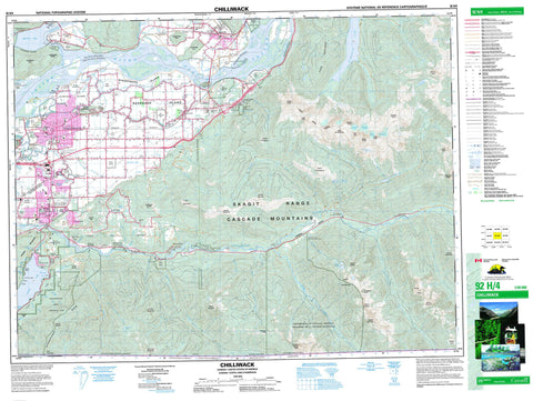
092H04 Chilliwack Canada topo map, 1:50,000 scale
092H04 Chilliwack NRCAN topographic map.
Includes UTM and GPS geographic coordinates (latitude and longitude). This 50k scale map is suitable for hiking, camping, and exploring, or you could frame it as a wall map.
Printed on-demand using high resolution, on heavy weight and acid free paper, or as an upgrade on a variety of synthetic materials.
Topos available on paper, Waterproof, Poly, or Tyvek. Usually shipping rolled, unless combined with other folded maps in one order.
- Product Number: NRCAN-092H04
- Parent Topo: TOPO-092H
- Map ID also known as: 092H04, 92H4, 92H04
- Unfolded Size: Approximately 26" high by 36" wide
- Weight (paper map): ca. 55 grams
- Map Type: POD NRCAN Topographic Map
- Map Scale: 1:50,000
- Geographical region: British Columbia, Canada
Neighboring Maps:
All neighboring Canadian topo maps are available for sale online at 1:50,000 scale.
Purchase the smaller scale map covering this area: Topo-092H
Spatial coverage:
Topo map sheet 092H04 Chilliwack covers the following places:
- Entrance Bay - Harrison Bay - Maple Bay - Chipmunk Caves - Slesse Creek Cave - Chilliwack - Kent - Bridal Veil Falls - New Westminster Land District - Yale Division Yale Land District - Foley Glacier - Lucky Four Glacier - Stewart Glacier - Wahleach Glacier - Aitchelitch Indian Reserve 9 - Cheam Indian Reserve 1 - Grass Indian Reserve 15 - Kwawkwawapilt Indian Reserve 6 - Popkum Indian Reserve 1 - Popkum Indian Reserve 2 - Réserve indienne Aitchelitch 9 - Réserve indienne Cheam 1 - Réserve indienne Grass 15 - Réserve indienne Kwawkwawapilt 6 - Réserve indienne Popkum 1 - Réserve indienne Popkum 2 - Réserve indienne Schelowat 1 - Réserve indienne Scowlitz 1 - Réserve indienne Seabird Island - Réserve indienne Skowkale 10 - Réserve indienne Skowkale 11 - Réserve indienne Skulkayn 10 - Réserve indienne Skulkayn 11 - Réserve indienne Skumalasph 16 - Réserve indienne Skwah 4 - Réserve indienne Skwahla 2 - Réserve indienne Skwali 3 - Réserve indienne Skway 5 - Réserve indienne Soowahlie 14 - Réserve indienne Squawkum Creek 3 - Réserve indienne Squiaala 7 - Réserve indienne Squiaala 8 - Réserve indienne Tseatah 2 - Réserve indienne Tzeachten 13 - Réserve indienne Williams 2 - Réserve indienne Yakweakwioose 12 - Schelowat Indian Reserve 1 - Scowlitz Indian Reserve 1 - Seabird Island Indian Reserve - Skowkale Indian Reserve 10 - Skowkale Indian Reserve 11 - Skulkayn Indian Reserve 10 - Skulkayn Indian Reserve 11 - Skumalasph Indian Reserve 16 - Skwah Indian Reserve 4 - Skwahla Indian Reserve 2 - Skwali Indian Reserve 3 - Skway Indian Reserve 5 - Soowahlie Indian Reserve 14 - Squawkum Creek Indian Reserve 3 - Squiaala Indian Reserve 7 - Squiaala Indian Reserve 8 - Tseatah Indian Reserve 2 - Tzeachten Indian Reserve 13 - Williams Indian Reserve 2 - Yakweakwioose Indian Reserve 12 - Cottonwood Island - Fairfield Island - Herrling Island - Hog Island - Queens Island - Rose Island - Rosebank Island - Sea Bird Island - Seabird Island - Windermere Island - Agassiz Slough - Bateson Slough - Bell Slough - Camp Slough - Cheam Lake - Cheam Slough - Coco-oppelo Slough - Cultus Lake - Duncan Slough - Foley Lake - Gravel Slough - Greyell Slough - Hogg Slough - Hope Slough - Ling Lake - Liumchen Lake - Maria Slough - Mountain Slough - Nelson Slough - Nicomen Slough - Pierce Lake - Ryder Lake - Sardis Pond - Shefford Slough - Wahleach Lake - Williamson Lake - Baby Munday Peak - Border Peak - Canadian Border Peak - Cascade Mountains - Cemetery Hill - Cheam Peak - Cheam Range - Cheam Ridge - Church Mountain - Conway Peak - Crossover Peak - Elk Mountain - Foley Peak - Four Brothers - Goetz Peak - Harrison Hill - Harrison Knob - Hopyard Hill - Illusion Peaks - International Ridge - Isar Mountain - Knight Peak - Lady Peak - Liumchen Mountain - Lookout Ridge - Mount Amadis - Mount Archibald - Mount Cope - Mount Corriveau - Mount Laughington - Mount Ling - Mount MacFarlane - Mount McGuire - Mount Mercer - Mount Parkes - Mount Pierce - Mount Rexford - Mount Shannon - Mount Thurston - Mount Tom - Skagit Range - Slesse Mountain - Spencer Peak - Stewart Peak - Teapot Hill - The Still - Vedder Mountain - Welch Peak - Williams Peak - Dewdney-Alouette Regional District - Fraser Valley Regional District - Regional District of Fraser-Cheam - Bridal Veil Falls Park - Chilliwack River Park - Cultus Lake Park - Ferry Island Park - International Ridge Park - International Ridge Recreation Area - Kilby General Store Museum - Kilby Historic Park - Kilby Park - Meadowland Park - Larsons Bench - British Columbia - Colombie-Britannique - Airplane Creek - Amadis Creek - Anderson Creek - Ascaphus Creek - Atchelitz Creek - Borden Creek - Bridal Creek - Calkins Creek - Centre Creek - Chilliwack Creek - Chilliwack River - Chilliwack River - Chipmunk Creek - Clear Creek - Dunville Creek - East Liumchen Creek - Elk Brook - Elk Creek - Fin Creek - Fleuve Fraser - Foley Creek - Ford Creek - Fraser River - Harrison River - Hatchery Creek - Laurel Creek - Little Chilliwack River - Little Tamihi Creek - Liumchen Creek - Luckakuck Creek - Marblehill Creek - McCallum Ditch - Midgley Creek - Nesakwatch Creek - Nevin Creek - Nursery Creek - Pierce Creek - Ryder Creek - Sasin Creek - Seedling Creek - Semmihault Creek - Slesse Creek - Smith Falls Creek - Squakum Creek - Squawkeem Creek - Squawkum Creek - Sweltzer River - Tamihi Creek - Teapot Creek - Vedder River - Wahleach Creek - Watt Creek - Wells Creek - Williamson Creek - Windfall Creek - Wingfield Creek - Young Creek - Agassiz - Bridal Falls - CFB Chilliwack - Cheam - Chilliwack - Cultus Lake - East Chilliwack - Fairfield - Greenacres - Harrison Mills - Magellan - Minto - Minto Landing - Popkum - Promontory - Promontory Heights - Rosedale - Ryder Lake - Sardis - Slesse Park - Smithvale - South Sumas - Vedder Crossing - Wells - Westview Subdivision


