
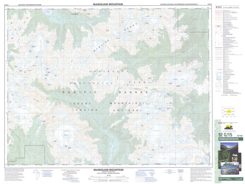
092G15 Mamquam Mountain Canada topo map, 1:50,000 scale
092G15 Mamquam Mountain NRCAN topographic map.
Includes UTM and GPS geographic coordinates (latitude and longitude). This 50k scale map is suitable for hiking, camping, and exploring, or you could frame it as a wall map.
Printed on-demand using high resolution, on heavy weight and acid free paper, or as an upgrade on a variety of synthetic materials.
Topos available on paper, Waterproof, Poly, or Tyvek. Usually shipping rolled, unless combined with other folded maps in one order.
- Product Number: NRCAN-092G15
- Parent Topo: TOPO-092G
- Map ID also known as: 092G15, 92G15
- Unfolded Size: Approximately 26" high by 36" wide
- Weight (paper map): ca. 55 grams
- Map Type: POD NRCAN Topographic Map
- Map Scale: 1:50,000
- Geographical region: British Columbia, Canada
Neighboring Maps:
All neighboring Canadian topo maps are available for sale online at 1:50,000 scale.
Purchase the smaller scale map covering this area: Topo-092G
Spatial coverage:
Topo map sheet 092G15 Mamquam Mountain covers the following places:
- Sphinx Bay - Bishop Glacier - Castle Towers Glacier - Cheakamus Glacier - Corrie Glacier - Diamond Glacier - Forger Glacier - Garibaldi Glacier - Garibaldi Névé - Glacier de Fleur des Neiges - Gray Glacier - Griffin Glacier - Helm Glacier - Icemantle Glacier - Isosceles Glacier - Lava Glacier - Mamquam Icefield - McBride Glacier - Misty Icefield - Nimbus Glacier - North Pitt Glacier - Phoenix Glacier - Pike Glacier - Sentinel Glacier - Snow Bowl Glacier - Snowcap Glacier - Snowcap Icefield - Solitude Glacier - South Pitt Glacier - Sphinx Glacier - Spire Glacier - Staircase Glacier - Stave Glacier - Terra Alba Glacier - Thunderclap Glacier - Tyee Glacier - Ubyssey Glacier - Warren Glacier - Cheakamus Lake - Cutoff Lake - Elfin Lakes - Garibaldi Lake - Hourglass Lake - Lower Snowcap Lake - Mamquam Lake - Misty Lake - Rampart Ponds - Snowcap Lake - Adieu Mountain - Caligo Peak - Castle Towers Mountain - Chaîne Côtière - Cheakamus Mountain - Coast Mountains - Corrie Peak - Corrie Ridge - Crosscut Ridge - Darling Peak - Deception Peak - Delusion Peak - Fitzsimmons Range - Gentian Peak - Gentian Ridge - Glacier Pikes - Greenmantle Mountain - Greymantle Mountain - Guard Mountain - Halkomelem Peak - Helm Peak - Hour Peak - Isosceles Peak - Mamquam Mountain - McBride Range - Misery Summit - Misty Peak - Mount Carr - Mount Castle Towers - Mount Davidson - Mount Luxor - Mount Pitt - Mount Sir Richard - Nimbus Peak - Nip and Tuck Peaks - Nivalis Mountain - Opal Cone - Pacific Ranges - Parapet Peak - Paul Ridge - Perce-Neige - Phyllis's Engine - Polemonium Ridge - Pyramid Mountain - Rain God Mountain - Roller Coaster Ridge - Schnee Kogel - Snowcap Peak - Spire Peaks - Stave Peak - Talon Peak - Tenas Peak - The Bookworm - The Bookworms - The Gargoyles - The Gatekeeper - The Lecture Cutters - The Orphans - The Sharkfin - The Sphinx - The Sphinx Mountain - The Tent - Three Bears Mountain - Tutankhamen Peak - Tuwasus Mountain - Veeocee Mountain - Viking Ridge - Dewdney-Alouette Regional District - Fraser Valley Regional District - Regional District of Fraser-Cheam - Garibaldi Park - Ayceecee Creek - Bucklin Creek - Castle Towers Creek - Cheakamus River - Corrie Creek - Detour Creek - Diavolo Creek - Gauguin Creek - Gautier Creek - Hellebore Creek - Helm Creek - Icemantle Creek - Iceworm Creek - Isosceles Creek - North Tuwasus Creek - Pitt River - Refuse Creek - Ring Creek - Skookum Creek - Snowcap Creek - South Tuwasus Creek - Stave River - Tuwasus Creek - Zig Zag Creek - Drop Pass - Gentian Pass - Gray Pass - Rain Door Pass - Rainbow Pass - Sphinx Pass - Tuwasus Pass - Eanastick Meadows


