
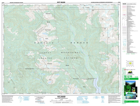
092G10 Pitt River Canada topo map, 1:50,000 scale
092G10 Pitt River NRCAN topographic map.
Includes UTM and GPS geographic coordinates (latitude and longitude). This 50k scale map is suitable for hiking, camping, and exploring, or you could frame it as a wall map.
Printed on-demand using high resolution, on heavy weight and acid free paper, or as an upgrade on a variety of synthetic materials.
Topos available on paper, Waterproof, Poly, or Tyvek. Usually shipping rolled, unless combined with other folded maps in one order.
- Product Number: NRCAN-092G10
- Parent Topo: TOPO-092G
- Map ID also known as: 092G10, 92G10
- Unfolded Size: Approximately 26" high by 36" wide
- Weight (paper map): ca. 55 grams
- Map Type: POD NRCAN Topographic Map
- Map Scale: 1:50,000
- Geographical region: British Columbia, Canada
Neighboring Maps:
All neighboring Canadian topo maps are available for sale online at 1:50,000 scale.
Purchase the smaller scale map covering this area: Topo-092G
Spatial coverage:
Topo map sheet 092G10 Pitt River covers the following places:
- Katzie Glacier - Nimbus Glacier - Piluk Glacier - Stave Glacier - Anne Lake - Barnes Lake - Belknap Lake - Clarion Lake - Consolation Lakes - Disappointment Lake - Don Lake - Isabel Lake - Joseph Lake - Little Anne Lake - Norton Lake - November Lake - Pinecone Lake - Pitt Lake - Pukulkul Lake - Warner Lake - Young Lake - Alpen Mountain - Betstel Pinnacle - Bivouac Mountain - Chaîne Côtière - Coast Mountains - Fannin Mountains - Fannin Range - Katzie Mountain - Meslilloet Mountain - Mount Alpen - Mount Bonnycastle - Mount Eldee - Mount Gillespie - Mount Jukes - Nebula Peak - Old Pierre Mountain - Pacific Ranges - Piluk Peak - Pukulkul Peak - Remote Peak - Skakala Peak - Skayuk Peak - Stalo Peak - Dewdney-Alouette Regional District - Fraser Valley Regional District - Garibaldi Park - Golden Ears Park - Pinecone Burke Park - Boise Creek - Brandt Creek - Bucklin Creek - Bull Creek - Caledonian Creek - Chief George Creek - Coquitlam River - Corbold Creek - Crawford Creek - DeBeck Creek - Fish Hatchery Creek - Forestry Creek - Four Mile Creek - Gurney Creek - Hixon Creek - Homer Creek - Indian River - Mamquam River - Martin Creek - Meslilloet Creek - Norton Creek - Pinecone Creek - Pitt River - Raffuse Creek - Ring Creek - Roy Creek - Seymour Creek - Seymour River - Shale Creek - Skookum Creek - Stave River - Steve Creek - Vickers Creek - Young Creek - Alvin


