
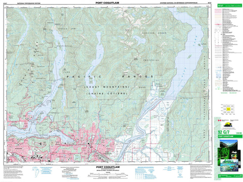
092G07 Port Coquitlam Canada topo map, 1:50,000 scale
092G07 Port Coquitlam NRCAN topographic map.
Includes UTM and GPS geographic coordinates (latitude and longitude). This 50k scale map is suitable for hiking, camping, and exploring, or you could frame it as a wall map.
Printed on-demand using high resolution, on heavy weight and acid free paper, or as an upgrade on a variety of synthetic materials.
Topos available on paper, Waterproof, Poly, or Tyvek. Usually shipping rolled, unless combined with other folded maps in one order.
- Product Number: NRCAN-092G07
- Parent Topo: TOPO-092G
- Map ID also known as: 092G07, 92G7, 92G07
- Unfolded Size: Approximately 26" high by 36" wide
- Weight (paper map): ca. 55 grams
- Map Type: POD NRCAN Topographic Map
- Map Scale: 1:50,000
- Geographical region: British Columbia, Canada
Neighboring Maps:
All neighboring Canadian topo maps are available for sale online at 1:50,000 scale.
Purchase the smaller scale map covering this area: Topo-092G
Spatial coverage:
Topo map sheet 092G07 Port Coquitlam covers the following places:
- Bedwell Bay - Belcarra Bay - Buntzen Bay - Burrard Inlet - Cosy Cove - Deep Cove - Farrer Cove - Helga Bay - Heron Cove - Indian Arm - Iron Bay - McPhaden Bay - Port Moody - Seal Bay - Subiaco Cove - Vancouver Harbour - Whiskey Cove - Goose Bar - Sunnyside Beach - Addington Point - Admiralty Point - Berry Point - Best Point - Burns Point - Cacus Point - Carraholly Point - Cozen Point - Deer Point - Dockrill Point - Gosse Point - Lone Rock Point - Reed Point - Roche Point - Rocky Point - Turtle Head - Grant Channel - Grant Narrows - Burnaby - Coquitlam - Pitt Meadows - Port Coquitlam - Port Moody - Cove Cliff - Maple Ridge - North Vancouver - Fairy Falls - Granite Falls - Russell Falls - Seymour Falls - Silver Falls - Spray of Pearls Falls - Sunshine Falls - Burrard Inlet Indian Reserve 3 - Coquitlam Indian Reserve 2 - Inlailawatash Indian Reserve 4 - Inlailawatash Indian Reserve 4A - Pitt Lake Indian Reserve 4 - Réserve indienne Burrard Inlet 3 - Réserve indienne Coquitlam 2 - Réserve indienne Inlailawatash 4 - Réserve indienne Inlailawatash 4A - Réserve indienne Pitt Lake 4 - Boulder Island - Coquitlam Island - Croker Island - Goose Island - Grey Rocks Island - Hamber Island - Jug Island - Little Goose Island - Racoon Island - Siwash Island - Twin Islands - Beautiful Lake - Bennie Lake - Betsy Lake - Bird Lake - Blaney Lake - Buntzen Lake - Burwell Lake - Catbird Slough - Clegg Lake - Como Lake - Consolation Lakes - Coquitlam Lake - Cornett Lakes - Cranberry Lake - Cranberry Slough - Crane Ponds - Cypress Lake - De Boville Slough - De Pencier Lake - Dennett Lake - Disc Lake - Dominion Avenue Slough - Elsay Lake - Eunice Lake - Fannin Lake - Fenton Road Slough - First Lake - Flower Lake - Gabbro Lake - Goldie Lake - Goose Lake - Gopher Lake - Gwendoline Lake - Hastings Lake - Hidden Lake - Irmy Lake - Jacobs Lake - Katherine Lake - Lafarge Lake - Loon Lake - Lost Lake - McCombe Lake - Mike Lake - Mirror Lake - Munday Lake - Munro Lake - Mystery Lake - Obelisk Lake - Peaceful Lake - Peneplain Lake - Percy Lake - Pitt Lake - Placid Lake - Quarry Slough - Rolf Lake - Rose Lake - Sasamat Lake - Second Lake - Seymour Lake - Shirley Lake - Spindle Lake - Sturgeon Slough - Surprise Lake - Talus Lake - Theta Lake - Vicar Lakes - Widgeon Lake - Widgeon Slough - Orlohma Beach - Big Pine Mountain - Bishop Mountain - Brockton Point - Burnt Hill - Capitol Hill - Chaîne Côtière - Coast Mountains - Coquitlam Mountain - Cypress Mountain - Dinkey Peak - Dog Mountain - Eagle Mountain - Fannin Mountains - Fannin Range - Gabbro Mountain - Golden Ears - Little Horn Mountain - Little Pine Mountain - Mount Bishop - Mount Blanshard - Mount Burke - Mount Burnaby - Mount Dickens - Mount Elsay - Mount Felix - Mount Seymour - Mystery Peak - Obelisk Peak - Pacific Ranges - Peneplain Peak - Pump Peak - Rocky Hill - Runner Peak - Sheridan Hill - Snake Rock - Tangled Summit - Widgeon Peak - Dewdney-Alouette Regional District - Fraser Valley Regional District - Golden Ears Park - Indian Arm Marine Park - Indian Arm Park - Mount Seymour Park - Mount Seymour Recreation Area - Pinecone Burke Park - Réserve nationale de faune de la Vallée-Widgeon - Widgeon Valley National Wildlife Area - Mount Seymour - Allan Creek - Alouette River - Annore Creek - Ashby Creek - Bishop Creek - Blakeny Creek - Blaney Creek - Booth Creek - Buntzen Creek - Burwell Creek - Cathedral Creek - Clementine Creek - Coldwell Creek - Como Creek - Coquitlam River - Dark Creek - DeBeck Creek - Defrauder Creek - Deiner Creek - Donegani Creek - Eloise Creek - Elsay Creek - Fannin Creek - Francis Creek - Gibbens Creek - Grand Creek - Gurney Creek - Gwendoline Creek - Hanging Creek - Hett Creek - Holmden Creek - Hoy Creek - Hyde Creek - Hydraulic Creek - Indian River - Irvine Creek - Jacobs Creek - Lighthall Creek - Loon Creek - MacIntyre Creek - Mantle Creek - Marquart Creek - Mayfly Creek - McCartney Creek - McKenzie Creek - McLean Creek - McSween Creek - Mossom Creek - Munro Creek - Neill Creek - Noons Creek - North Alouette River - Or Creek - Osprey Creek - Partington Creek - Partridge Creek - Paton Creek - Percy Creek - Pitt River - Pritchett Creek - Raven Creek - School House Brook - Scott Creek - Scott-Goldie Creek - Seymour Creek - Seymour River - Shone Creek - Smiling Creek - Spring Creek - Stephenson Creek - Still Creek - Stoney Creek - Sunshine Creek - Taylor Creek - Underhill Creek - Watkins Creek - West Noons Creek - Widgeon Creek - Wigwam Creek - Williams Creek - Windermere Creek - Chatham Reach - Fox Reach - Belvedere Rock - Black Shoal - Charles Reef - Lone Rock - Tupper Rock - White Rock - Alder Creek - Arbutus Ridge - Austin Heights - Barnet - Belvedere - Bergs - Birchland Manor - Blueridge - Brentwood Park - Brighton Beach - Britamoco - Buntzen Bay - Burquitlam - Canyon Heights - Capilano Highlands - Capitol Hill - Carraholly - Cascade - Cassin - Chineside - Cleveland Park - Coldwell Beach - Coombe - Coquitlam - Cosy Cove - Cove Cliff - Deep Cove - Deepwater - Delbrook - Dollarton - Dunbar-Southlands - Eagle Ridge - Essondale - Fernlee - Forest Hills - Frames - Granite Falls - Grey Rocks - Harbour Chines - Harbour Village - Hastings Road - Ioco - Ioco Junction - Iron Bay - Johnson - Keith-Lynn - Kensington-Cedar Cottage - Kerrisdale - Killarney - Lake Buntzen - Laurentian Belaire - Lincoln Park - Lochdale - Maillardville - Meadowbrook - Norgate - North Woodlands - Oakridge - Orlomah Beach - Oxford Heights - Pleasantside - Ranch Park - Renfrew-Collingwood - Riley Park - River Springs - Seymour Heights - Shaughnessy - Shellburn - Silver Falls - Silver Valley - South Cambie - Strathcona - Strathcona - Sullivan Heights - Sun Valley - Sunnyside - Sunset - Sunshine - Thwaytes - Twin Islands - Upper Lynn - Victoria-Fraserview - West End - West Lynn - Westridge - Wigwam Inn - Williams Landing - Windsor Park - Woodhaven - Woodlands - Homilk'um Marsh - Katzie Marsh - Pitt Marsh - Smohk'wa Marsh - Anmore - Belcarra


