
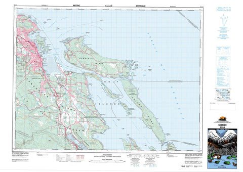
092G04 Nanaimo Canada topo map, 1:50,000 scale
092G04 Nanaimo NRCAN topographic map.
Includes UTM and GPS geographic coordinates (latitude and longitude). This 50k scale map is suitable for hiking, camping, and exploring, or you could frame it as a wall map.
Printed on-demand using high resolution, on heavy weight and acid free paper, or as an upgrade on a variety of synthetic materials.
Topos available on paper, Waterproof, Poly, or Tyvek. Usually shipping rolled, unless combined with other folded maps in one order.
- Product Number: NRCAN-092G04
- Parent Topo: TOPO-092G
- Map ID also known as: 092G04, 92G4, 92G04
- Unfolded Size: Approximately 26" high by 36" wide
- Weight (paper map): ca. 55 grams
- Map Type: POD NRCAN Topographic Map
- Map Scale: 1:50,000
- Geographical region: British Columbia, Canada
Neighboring Maps:
All neighboring Canadian topo maps are available for sale online at 1:50,000 scale.
Purchase the smaller scale map covering this area: Topo-092G
Spatial coverage:
Topo map sheet 092G04 Nanaimo covers the following places:
- Baines Bay - Boat Harbour - Burleith Arm - Clark Bay - Coal Mine Bay - Commercial Bay - Commercial Inlet - Cufra Inlet - Davidson Bay - Degnen Bay - Departure Bay - Descanso Bay - Duke Inlet - Hammond Bay - Herring Bay - Keel Cove - Kenary Cove - Kulleet Bay - Ladysmith Harbour - Leboeuf Bay - Lighthouse Bay - Lock Bay - Logan Bay - Mark Bay - Nanaimo Harbour - Nicholson Cove - Noel Bay - North Cove - Oyster Harbour - Percy Anchorage - Pilot Bay - Pirate Cove - Pirates Cove - Silva Bay - Taylor Bay - Wakes Cove - West Bay - Sunset Beach - Alcala Point - Angle Point - Batchelor Point - Bate Point - Berry Point - Blackberry Point - Brechin Point - Cardale Point - Cayetano Point - Cordero Point - Deer Point - Detwiller Point - Dibuxante Point - Dionisio Point - Duke Point - Flewett Point - Fraser Point - Gallows Point - Good Point - Jack Point - Joan Point - Josef Point - Lagoon Head - Law Point - Malaspina Point - McKay Point - Nares Point - Neck Point - Orlebar Point - Page Point - Pilkey Point - Pimbury Point - Purvis Point - Race Point - Reynolds Point - Rowboat Point - Shaft Point - Shah Point - Shingle Point - Stuart Point - Tinson Point - Tyne Point - Vernaci Point - Virago Point - Wedge Point - Williams Point - Yellow Point - Commodore Passage - Dodd Narrows - Fairway Channel - False Narrows - Forwood Channel - Gabriola Passage - Horswell Channel - McKay Channel - Newcastle Island Passage - Northumberland Channel - Porlier Pass - Pylades Channel - Rainbow Channel - Ruxton Passage - Strait of Georgia - Stuart Channel - Trincomali Channel - Whaleboat Passage - Nanaimo - Galiano Gallery - Horswell Bluff - Bright Land District - Cedar Land District - Cowichan Land District - Cranberry Land District - Douglas Land District - Mountain Land District - Nanaimo Land District - New Westminster Land District - Oyster Land District - Wellington Land District - Burial Ground Indian Reserve 6 - Chemainus Indian Reserve 13 - Gabriola Island Indian Reserve 5 - Galiano Island Indian Reserve 9 - Lyacksun Indian Reserve 3 - Ma-Guala Indian Reserve 6 - Nanaimo River Indian Reserve 2 - Nanaimo River Indian Reserve 3 - Nanaimo River Indian Reserve 4 - Nanaimo Town Indian Reserve 1 - Oyster Bay Indian Reserve 12 - Portier Pass Indian Reserve 5 - Réserve indienne Burial Ground 6 - Réserve indienne Chemainus 13 - Réserve indienne Gabriola Island 5 - Réserve indienne Galiano Island 9 - Réserve indienne Lyacksun 3 - Réserve indienne Ma-Guala 6 - Réserve indienne Nanaimo River 2 - Réserve indienne Nanaimo River 3 - Réserve indienne Nanaimo River 4 - Réserve indienne Nanaimo Town 1 - Réserve indienne Oyster Bay 12 - Réserve indienne Portier Pass 5 - Réserve indienne Shingle Point 4 - Shingle Point Indian Reserve 4 - Acorn Island - Bath Island - Brandon Island - Brandon Islands - Breakwater Island - Canoe Islet - Carlos Island - De Courcy Group - De Courcy Island - Entrance Island - Five Finger Island - Flat Top Islands - Gabriola Island - Galiano Island - Gaviola Island - Gulf Islands - Île de Vancouver - Jesse Island - Kendrick Island - Lily Island - Link Island - Miami Islet - Mudge Island - Newcastle Island - Protection Island - Pylades Island - Ragged Islets - Reid Island - Rose Islets - Round Island - Ruxton Island - Saturnina Island - Sear Island - Snake Island - Thetis Island - Tree Island - Tugboat Island - Valdes Island - Vance Island - Vancouver Island - Whaleboat Island - Woods Islands - Beck Lake - Blind Lake - Cathers Lake - Crystal Lake - Greenway Lake - Harewood Lake - Hoggan Lake - Holden Lake - Long Lake - Lost Lake - McKay Lake - Michael Lake - Myles Lake - Overton Lake - Page Lagoon - Priest Lake - Quennell Lake - Richard Lake - Stark Lakes - Timberland Lake - Westwood Lake - Whisky Lake - York Lake - Champ de tir Nanaimo - Nanaimo Range - Mexicana Hill - Moore Hill - Mount Hayes - Vancouver Island Ranges - Woodley Range - Capital Regional District - Cowichan Valley Regional District - Greater Vancouver Regional District - Regional District of Nanaimo - Dionisio Point Park - Drumbeg Park - Gabriola Sands Park - Gabriola Sands Recreation Area - Hemer Park - Ivy Green Park - Morden Colliery Historic Park - Newcastle Island Marine Park - Newcastle Island Park - Newcastle Island Recreation Area - Petroglyph Park - Pirates Cove Marine Park - Roberts Memorial Park - Sandwell Park - Whaleboat Island Marine Park - Harewood Plains - Beck Creek - Berkley Creek - Bush Creek - Chase River - Cottle Creek - Departure Creek - Elkhorn Creek - Haslam Creek - Hokkanen Creek - Meakin Channel - Millstone River - Nanaimo River - North Cottle Creek - North Haslam Creek - Northfield Creek - Stark Creek - Tyee Creek - Beacon Rock - Black Rock - Black Rock - Boscowitz Rock - Brant Reef - Carpenter Rock - Clarke Rock - Danger Reefs - Gabriola Reefs - Horswell Rock - Hudson Rocks - Inskip Rock - Middle Bank - Oregon Rock - Passage Rock - Power Squadron Reef - Rogers Reef - Romulus Reef - Romulus Rock - Satellite Reef - Shipyard Rock - Thrasher Rock - Three Fathom Patches - Virago Rock - Boat Harbour - Brenton - Cassidy - Cedar - Chase - Chase River - Cinnabar Valley - Departure Bay - Extension - Fiddicks - Gabriola - Gabriola Island - Harmac - Newcastle - North Gabriola - North Galiano - Northfield - Silvene - South Wellington - Starks - Stockett - Storms - Stovely - Wellcox - Buttertubs Marsh


