
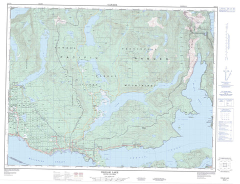
092F16 Haslam Lake Canada topo map, 1:50,000 scale
092F16 Haslam Lake NRCAN topographic map.
Includes UTM and GPS geographic coordinates (latitude and longitude). This 50k scale map is suitable for hiking, camping, and exploring, or you could frame it as a wall map.
Printed on-demand using high resolution, on heavy weight and acid free paper, or as an upgrade on a variety of synthetic materials.
Topos available on paper, Waterproof, Poly, or Tyvek. Usually shipping rolled, unless combined with other folded maps in one order.
- Product Number: NRCAN-092F16
- Parent Topo: TOPO-092F
- Map ID also known as: 092F16, 92F16
- Unfolded Size: Approximately 26" high by 36" wide
- Weight (paper map): ca. 55 grams
- Map Type: POD NRCAN Topographic Map
- Map Scale: 1:50,000
- Geographical region: British Columbia, Canada
Neighboring Maps:
All neighboring Canadian topo maps are available for sale online at 1:50,000 scale.
Purchase the smaller scale map covering this area: Topo-092F
Spatial coverage:
Topo map sheet 092F16 Haslam Lake covers the following places:
- Annis Bay - Baker Bay - Brew Bay - Earl Cove - Earls Cove - Fairview Bay - Frolander Bay - Granville Bay - Hotham Sound - Jervis Inlet - Lang Bay - Lena Bay - McMurray Bay - McRae Cove - Mermaid Cove - Saltery Bay - St. Vincent Bay - Stillwater Bay - Thunder Bay - Vanguard Bay - Ahlstrom Point - Albion Point - Ball Point - Berry Point - Black (Albion) Point - Cook Point - Culloden Point - Elephant Point - Kelly Point - Myrtle Point - Syren Point - Thunder Point - Agamemnon Channel - Malaspina Strait - Telescope Passage - Harmony Falls - Comox Land District - New Westminster Land District - Texada Island Land District - Cokqueneets Indian Reserve 23 - Réserve indienne Cokqueneets 23 - Réserve indienne Slayathlum 16 - Slayathlum Indian Reserve16 - Copper Island - Eagle Island - Goat Island - Hardy Island - Harmony Islands - Junction Island - Nelson Island - Sykes Island - Agnes Lake - Alpha Lake - Arrowhead Lake - Barren Lake - Beaver Lake - Beta Lake - Brooks Lake - Confederation Lake - Deep Lake - Diadem Lake - Dodd Lake - Duck Lake - East Lake - Elephant Lake - Freda Lake - Gamma Lake - Giavanno Lake - Gordon Pasha Lake - Granite Lake - Grey Lake - Hammil Lake - Haslam Lake - Horseshoe Lake - Inland Lake - Ireland Lake - Khartoum Lake - Lac Godeau - Lena Lake - Lewis Lake - Little Horseshoe Lake - Liz Lake - Lizard Lake - Lois Lake - March Lake - McVey Lake - My Lake - Nanton Lake - Phelan Lake - Powell Lake - Rainy Day Lake - Rainyday Lake - Shoe Lake - Sonja Lake - Tony Lake - Useless Lake - Walt Lake - Windsor Lake - Chaîne Côtière - Coast Mountains - Diadem Mountain - Hammil Hill - Leaning Tree Hill - Mount Mahony - Mount Troubridge - O'Connells Hill - Pacific Ranges - Parker Range - Smith Range - The Knuckles - The Sentinel - Tin Hat Mountain - Walts Hill - Powell River Regional District - Cokoqueneets SB 23 - Slayathlum SB 16 - Harmony Islands Marine Park - Haslam Lake Park - Inland Lake Park - Palm Beach Park - Saltery Bay Park - Bishop Creek - Brittain River - Campsite Creek - Community Creek - Dayton Creek - Deighton Creek - Egmont Creek - Freda Creek - Freil Creek - Horseshoe River - Jefferd Creek - Kelly Creek - Kellybrew Creek - Lang Creek - Lois River - Myrtle Creek - Park Creek - Powell River - Saltery Creek - Scanlon Creek - Treth Creek - Whittall Creek - Princess Royal Reach - Myrtle Rocks - Brew Bay - Earls Cove - Lang Bay - McCalls Landing - Myrtle Point - Saltery Bay - Sechelt Indian Government District - Stillwater


