
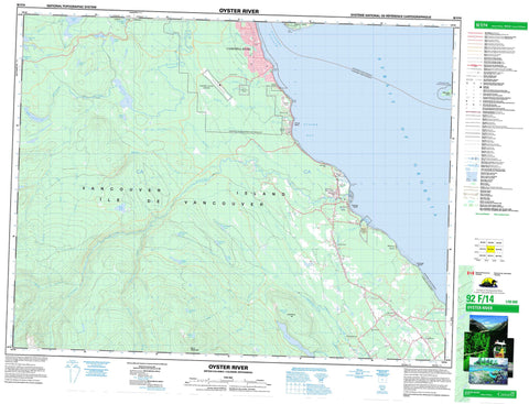
092F14 Oyster River Canada topo map, 1:50,000 scale
092F14 Oyster River NRCAN topographic map.
Includes UTM and GPS geographic coordinates (latitude and longitude). This 50k scale map is suitable for hiking, camping, and exploring, or you could frame it as a wall map.
Printed on-demand using high resolution, on heavy weight and acid free paper, or as an upgrade on a variety of synthetic materials.
Topos available on paper, Waterproof, Poly, or Tyvek. Usually shipping rolled, unless combined with other folded maps in one order.
- Product Number: NRCAN-092F14
- Parent Topo: TOPO-092F
- Map ID also known as: 092F14, 92F14
- Unfolded Size: Approximately 26" high by 36" wide
- Weight (paper map): ca. 55 grams
- Map Type: POD NRCAN Topographic Map
- Map Scale: 1:50,000
- Geographical region: British Columbia, Canada
Neighboring Maps:
All neighboring Canadian topo maps are available for sale online at 1:50,000 scale.
Purchase the smaller scale map covering this area: Topo-092F
Spatial coverage:
Topo map sheet 092F14 Oyster River covers the following places:
- Elma Bay - Oyster Bay - Stuart Bay - Conawaga Beach - Saratoga Beach - Stories Beach - Cape Mudge - Kuhushan Point - Shelter Point - Willow Point - Discovery Passage - Strait of Georgia - Campbell River - Comox Land District - Nanaimo Land District - Sayward Land District - Cape Mudge Indian Reserve 10 - Homalco 9 - Homalco Indian Reserve 9 - Réserve indienne Cape Mudge 10 - Réserve indienne Homalco 9 - Île de Vancouver - Mitlenatch Island - Quadra Island - Vancouver Island - Beavertail Lake - Blue Grouse Lake - Campbell Lake - Echo Lake - Gilson Lake - Hell Diver Lake - Kalmia Lake - Little Lost Lake - Loon Lake - Lost Lake - Lukwa Lake - McKay Lake - Middle Quinsam Lake - Mirror Lake - Northy Lake - Oyster Pond - Pyrrhotite Lake - Quinsam Lake - Regan Lake - Snake Lake - Snakehead Lake - Wolf Lake - Wowo Lake - Constitution Hill - Mount Washington - Vancouver Island Mountains - Vancouver Island Ranges - Miracle Beach Park - Mitlenatch Island Nature Park - Adrian Creek - Balsam Creek - Bear Creek - Beaver Creek - Beavertail Creek - Black Creek - Chute Creek - Goss Creek - Headquarters Creek - Iron River - Kitty Coleman Creek - Little Oyster River - McKay Creek - Miller Creek - Murex Creek - Newman Creek - Oyster River - Piggott Creek - Portuguese Creek - Pyrrhotite Creek - Quinsam River - Sayer Creek - Simms Creek - Stone Creek - Storie Creek - Tsolum River - Willow Creek - Woodhus Creek - Woods Creek - Wilby Shoals - Black Creek - Grantham - Headquarters - Merville - Ocean Grove - Oyster River - Quinsam - Saratoga Beach - Shelter Point - Stories Beach - Williams Beach


