
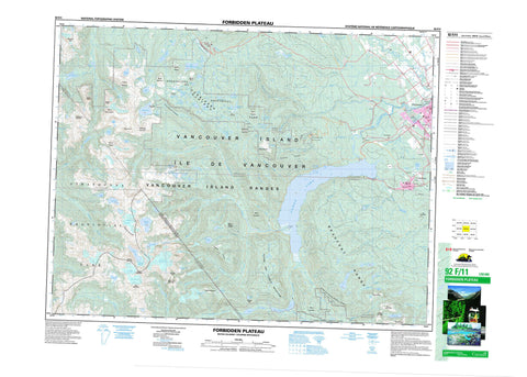
092F11 Forbidden Plateau Canada topo map, 1:50,000 scale
092F11 Forbidden Plateau NRCAN topographic map.
Includes UTM and GPS geographic coordinates (latitude and longitude). This 50k scale map is suitable for hiking, camping, and exploring, or you could frame it as a wall map.
Printed on-demand using high resolution, on heavy weight and acid free paper, or as an upgrade on a variety of synthetic materials.
Topos available on paper, Waterproof, Poly, or Tyvek. Usually shipping rolled, unless combined with other folded maps in one order.
- Product Number: NRCAN-092F11
- Parent Topo: TOPO-092F
- Map ID also known as: 092F11, 92F11
- Unfolded Size: Approximately 26" high by 36" wide
- Weight (paper map): ca. 55 grams
- Map Type: POD NRCAN Topographic Map
- Map Scale: 1:50,000
- Geographical region: British Columbia, Canada
Neighboring Maps:
All neighboring Canadian topo maps are available for sale online at 1:50,000 scale.
Purchase the smaller scale map covering this area: Topo-092F
Spatial coverage:
Topo map sheet 092F11 Forbidden Plateau covers the following places:
- Boston Bay - Old Camp Point - Courtenay - Clayoquot Land District - Comox Land District - Nelson Land District - Newcastle Land District - Nootka Land District - Aureole Icefield - Aureole Snowfield - Cliffe Glacier - Comox Glacier - Moving Glacier - Pentledge Indian Reserve 2 - Réserve indienne Pentledge 2 - Île de Vancouver - Stuart Wood Island - Vancouver Island - Aldermen Lakes - Allen Lake - Amphitheatre Lake - Anderson Lake - Arum Lake - Ash Pond - Aston Pond - Ball Lake - Battleship Lake - Beaufort Lake - Boston Lake - Capes Lake - Carey Lakes - Century Sam Lake - Charity Lake - Circlet Lake - Comox Lake - Cottingham Lake - Cougar Lake - Croteau Lake - Delight Lake - Divers Lake - Douglas Lake - Dove Lake - Drabble Lakes - Duncan Lake - Esther Lake - Faith Lake - Forbush Lake - Gem Lake - Gordon Wood Lake - Hairtrigger Lake - Hamilton Lake - Harris Lake - Hope Lake - Idiens Lake - Ink Lake - Jack Shark Lake - John Brown Lake - Johnson Lake - Johnston Lake - Kim Lake - Kooso Lake - Kwai Lake - Kwassun Lake - Lady Lake - Lake Beautiful - Lake Helen Mackenzie - Lunchtime Lake - Maple Lake - Mariwood Lake - McKenzie Lake - McPhee Lake - McQuillan Lake - Meadow Lake - Memory Lake - Milla Lake - Mirren Lake - Moat Lake - Netuts Lake - Nimnim Lake - Norm Lake - Panther Lake - Paradise Ponds - Pearl Lake - Pearse Lake - Pigeon Pond - Poum Lake - Ralph Lake - Rossiter Lake - Ruth Masters Lake - Seeam Lake - Silver Snag Lake - Simms Lake - Sunrise Lake - Tatsno Lakes - Teal Lake - Trout Lake - Tsable Lake - Tzela Lake - Wagner Lakes - Willemar Lake - Wolf Lake - Alexandra Peak - Alone Mountain - Argus Mountain - Augerpoint Mountain - Augurpoint Mountain - Beaufort Range - Black Cat Mountain - Boston Ridge - Capes Ridge - Castlecrag Mountain - Iceberg Peak - Indian Head Mountain - Indianhead Mountain - Jap Mountain - Jutland Mountain - Kookjai Mountain - Mitch Mountain - Mount Albert Edward - Mount Allan Brooks - Mount Becher - Mount Brooks - Mount Chief Frank - Mount Clifton - Mount Drabble - Mount Elma - Mount Frink - Mount George V - Mount Ginger Goodwin - Mount Harmston - Mount Hennessy - Mount Jutland - Mount Mitchell - Mount Regan - Mount Stubbs - Nikkei Mountain - Rees Ridge - Rough and Tumble Mountain - Strata Mountain - The Red Pillar - Tsable Mountain - Vancouver Island Mountains - Vancouver Island Ranges - Comox Valley Regional District - Regional District of Alberni-Clayoquot - Regional District of Comox-Strathcona - Strathcona Park - Wood Mountain Ski Park - Forbidden Plateau - Arden Creek - Ash River - Beaufort Creek - Beech Creek - Bloedel Creek - Boston Creek - Browns River - Capes Creek - Comox Creek - Cruickshank River - Cumberland Creek - Datsio Creek - Dove Creek - Eric Creek - First Supply Creek - Gem Creek - Ginger Goodwin Creek - Goodwin Creek - Goss Creek - Harding Creek - Headquarters Creek - Henshaw Creek - Idiens Creek - Idle Creek - Jackpot Creek - Karst Creek - Katlum Creek - Kweishun Creek - Millard Creek - Morrison Creek - Nellie Creek - Nimnim Creek - Norm Creek - Oyster River - Paradise Creek - Pearce Creek - Perseverance Creek - Piercy Creek - Piggott Creek - Portuguese Creek - Puntledge River - Ralph River - Ramparts Creek - Red Pillar Creek - Rees Creek - Shepherd Creek - Siokum Creek - Supply Creek - Toma Creek - Tremain Creek - Trent River - Tsable River - Tsolum River - Wattaway Creek - Willemar Creek - Bevan - Mount Washington - Puntledge - Union - Comox Gap - Cruickshank Canyon - Lone Tree Pass - McKenzie Meadows - Murray Meadows - Paradise Meadows - Slingshot Meadows - Wattaway Meadows - Whiskey Meadows - Cumberland


