
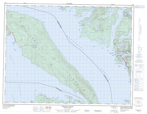
092F09 Texada Island Canada topo map, 1:50,000 scale
092F09 Texada Island NRCAN topographic map.
Includes UTM and GPS geographic coordinates (latitude and longitude). This 50k scale map is suitable for hiking, camping, and exploring, or you could frame it as a wall map.
Printed on-demand using high resolution, on heavy weight and acid free paper, or as an upgrade on a variety of synthetic materials.
Topos available on paper, Waterproof, Poly, or Tyvek. Usually shipping rolled, unless combined with other folded maps in one order.
- Product Number: NRCAN-092F09
- Parent Topo: TOPO-092F
- Map ID also known as: 092F09, 92F9, 92F09
- Unfolded Size: Approximately 26" high by 36" wide
- Weight (paper map): ca. 55 grams
- Map Type: POD NRCAN Topographic Map
- Map Scale: 1:50,000
- Geographical region: British Columbia, Canada
Neighboring Maps:
All neighboring Canadian topo maps are available for sale online at 1:50,000 scale.
Purchase the smaller scale map covering this area: Topo-092F
Spatial coverage:
Topo map sheet 092F09 Texada Island covers the following places:
- Anderson Bay - Ballet Bay - Bargain Bay - Bargain Harbour - Bill Bay - Billings Bay - Blind Bay - Cockburn Bay - Cook Bay - Davie Bay - Deep Bay - Dingman Bay - Duncan Cove - False Bay - Farrington Cove - Flat Rock Bay - Francis Bay - Garden Bay - Gerrans Bay - Gillies Bay - Green Bay - Gunboat Bay - Hidden Basin - Hospital Bay - Jervis Inlet - Joe Bay - Lee Bay - Log Boom Cove - Martin Cove - McRae Cove - Mouat Bay - Northeast Bay - Orchard Bay - Pender Harbour - Pocahontas Bay - Quarry Bay - Raven Bay - Scottie Bay - Skerry Bay - Spring Bay - Tucker Bay - Vanguard Bay - Welbourn Cove - Whiskey Cove - Alexander Point - Cape Cockburn - Daniel Point - Epsom Point - Evenden Point - Fearney Point - Francis Peninsula - Francis Point - Garden Peninsula - Harwood Point - Henry Point - Maynard Head - McNaughton Point - Mermaid Point - Moore Point - Northeast Point - Partington Point - Potter Point - Scotch Fir Point - Sechelt Peninsula - Seechelt Peninsula - Wells Point - West Point - Spanish Cave - Agamemnon Channel - Bargain Narrows - Bull Passage - Malaspina Strait - Sabine Channel - Stevens Passage - Strait of Georgia - Telescope Passage - The Gap - Nanaimo Land District - New Westminster Land District - Texada Island Land District - Bargain Harbour Indian Reserve 24 - Réserve indienne Bargain Harbour 24 - Réserve indienne Sallahlus 20 - Réserve indienne Sallahlus 20A - Réserve indienne Saughanaught 22 - Réserve indienne Sekaleton 21 - Réserve indienne Sekaleton 21A - Réserve indienne Suahbin 19 - Réserve indienneSawquamain 19A - Sallahlus Indian Reserve 20 - Sallahlus Indian Reserve 20A - Saughanaught Indian Reserve 22 - Sawquamain Indian Reserve 19A - Sekaleton Indian Reserve 21 - Sekaleton Indian Reserve 21A - Suahbin Indian Reserve 19 - Ada Island - Beaver Island - Berge Islet - Bishop Islet - Boho Island - Bunny Island - Calder Island - Caldwell Island - Carlsen Islet - Charles Island - Clio Island - Dick Island - Dusenbury Island - Edgecombe Island - Fegan Islets - Fegen Islets - Finnerty Islands - Fisher Island - Fox Island - Goat Islet - Hardy Island - Harness Island - Hodgson Islands - Jedediah Island - Jedidiah Island - Jelina Island - JervisIsland - Kelly Island - Larson Islet - Lasqueti Island - Lindbergh Island - Marr Island - Martin Island - Mary Island - Mary Islet - McRae Islet - Mouat Islands - Nelson Island - Nocturne Island - North Thormanby Island - Oyster Island - Paul Island - Pearson Island - Routh Islet - Sims Islet - Skardon Islands - Strawberry Islet - Texada Island - Thormanby Islands - Watt Islet - Whitestone Island - Whitestone Islands - Williams Island - Ambrose Lake - Bobs Lake - Bruce Lake - Chackchack Lake - Cockburn Lake - Cranby Lake - Garden Bay Lake - Hotel Lake - Katherine Lake - Kokomo Lake - Lee Lake - Lily Lake - Little Quarry Lake - Mackechnie Lake - Mixal Lake - Paq Lake - Quarry Lake - Ruby Lake - Sakinaw Lake - West Lake - Whiskey Slough - Yolana Lake - Zoe Lake - Cecil Hill - Comet Mountain - Harbour Peak - Mount Daniel - Mount Davies - Mount Dick - Mount Grant - Mount Pocahontas - Mount Shepherd - Pender Hill - Bargain Harbour SB 24 - Sallahlus SB 20 - Sallahlus SB 20A - Saughanaught SB 22 - Sawquamain SB 19A - Sekaleton SB 21 - Sekaleton SB 21A - Suahbin SB 19 - Anderson Bay Park - Francis Point Park - Garden Bay Marine Park - Musket Island Marine Park - Sabine Channel Marine Park - South Texada Island Park - Bruce Creek - Cook Creek - Cranby Creek - Egmont Creek - Haslam Creek - Mouat Creek - Napier Creek - Paq Creek - Rumbottle Creek - Russ Creek - Silversands Creek - Staaf Creek - Whiskey Still Creek - Achilles Bank - Acland Rock - Avery Reef - Bjerre Shoal - Griffin Ledge - Jacob Rock - Nares Rock - Nelson Rock - Neville Rock - Sinclair Bank - Temple Rock - Tuck Rock - Western Rock - Billings Bay - Donnely Landing - Garden Bay - Gillies Bay - Irvines Landing - Irvine's Landing - Madeira Park - Pender Harbour - Pope Landing - Sechelt Indian Government District


