
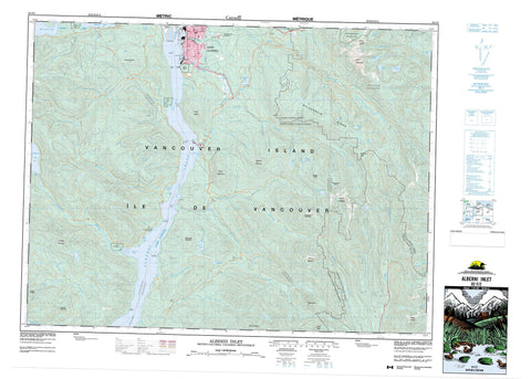
092F02 Alberni Inlet Canada topo map, 1:50,000 scale
092F02 Alberni Inlet NRCAN topographic map.
Includes UTM and GPS geographic coordinates (latitude and longitude). This 50k scale map is suitable for hiking, camping, and exploring, or you could frame it as a wall map.
Printed on-demand using high resolution, on heavy weight and acid free paper, or as an upgrade on a variety of synthetic materials.
Topos available on paper, Waterproof, Poly, or Tyvek. Usually shipping rolled, unless combined with other folded maps in one order.
- Product Number: NRCAN-092F02
- Parent Topo: TOPO-092F
- Map ID also known as: 092F02, 92F2, 92F02
- Unfolded Size: Approximately 26" high by 36" wide
- Weight (paper map): ca. 55 grams
- Map Type: POD NRCAN Topographic Map
- Map Scale: 1:50,000
- Geographical region: British Columbia, Canada
Neighboring Maps:
All neighboring Canadian topo maps are available for sale online at 1:50,000 scale.
Purchase the smaller scale map covering this area: Topo-092F
Spatial coverage:
Topo map sheet 092F02 Alberni Inlet covers the following places:
- Alberni Inlet - Hook Bay - Macktush Bay - Nahmint Bay - Port Alberni - Port Alberni Harbour - Stirling Arm - Two Rivers Arm - Uchucklesit Inlet - Underwood Cove - Bilton Point - Dunsmuir Point - Hocking Point - Katharine Point - Lone Tree Point - Lupsi Cupsi Point - Polly Point - River Point - Stamp Point - Ten Mile Point - Sproat Narrows - Stamp Narrows - Port Alberni - Upper Falls - Alberni Land District - Barclay Land District - Cameron Land District - Clayoquot Land District - Cowichan Lake Land District - Dunsmuir Land District - Alberni Indian Reserve 2 - Chuchakacook Indian Reserve 4 - Cous Indian Reserve 3 - Kleykleyhous Indian Reserve 5 - Réserve indienne Alberni 2 - Réserve indienne Chuchakacook 4 - Réserve indienne Cous 3 - Réserve indienne Kleykleyhous 5 - Hohm Island - Hoik Island - Île de Vancouver - Johnstone Island - Observatory Island - Sheep Island - Vancouver Island - Arrowsmith Lake - Bainbridge Lake - Cass Lake - Cox Lake - Devils Den Lake - Duck Lake - Father and Son Lake - Fishtail Lake - Hawthorn Lake - Henry Lake - Hidden Lake - Kammat Lake - Kildonan Lake - Lizard Lake - Lizard Pond - Nahmint Lake - Peak Lake - Rowbotham Lake - Sproat Lake - Summit Lake - Arbutus Summit - Douglas Peak - Hannah Mountain - Hecate Mountain - Hiwatchas Mountain - Limestone Mountain - Logan Peak - McKinlay Peak - McLaughlin Ridge - Mount Arrowsmith - Mount Cokely - Mount Douglas - Mount Halliday - Mount Hankin - Mount Hannah - Mount Hooper - Mount McQuillan - Mount Olsen - Mount Parsons - Mount Spencer - Mount Underwood - Patlicant Mountain - The Hump - Vancouver Island Mountains - Vancouver Island Ranges - Cowichan Valley Regional District - Regional District of Alberni-Clayoquot - Regional District of Nanaimo - China Creek Park - Fosselli Park - Fossli Park - Mount Arrowsmith Park - Borden Creek - Cameron River - Cass Creek - Chesnucknuw Creek - Child Creek - China Creek - Coleman Creek - Cook Creek - Cop Creek - Corrigan Creek - Cous Creek - Debeaux Creek - Englishman River - Follinsbee Creek - Fosseli Creek - Fosselli Creek - Fossli Creek - Franklin Creek - Franklin River - French Creek - Handy Creek - Kammat Creek - Lockwood Creek - Lupsi Cupsi Creek - Macktush Creek - McBey Creek - McFarland Creek - McLaughlin Creek - McQuillan Creek - Mineral Creek - Museum Creek - Nahmint River - Nanaimo River - Nitinat River - North McFarland Creek - Owatchet Creek - Parsons Creek - Pool Creek - Rift Creek - Rogers Creek - Sadie Creek - Ship Creek - Somass River - St. Andrew Creek - St. Dennis Creek - Williams Creek - Yellows Creek - Arrowview Heights - Cameron Heights - Franklin River - Locharkaig - Nahmint - King Solomon Basin


