
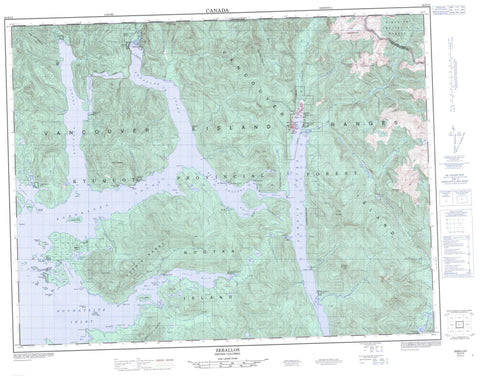
092E15 Zeballos Canada topo map, 1:50,000 scale
092E15 Zeballos NRCAN topographic map.
Includes UTM and GPS geographic coordinates (latitude and longitude). This 50k scale map is suitable for hiking, camping, and exploring, or you could frame it as a wall map.
Printed on-demand using high resolution, on heavy weight and acid free paper, or as an upgrade on a variety of synthetic materials.
Topos available on paper, Waterproof, Poly, or Tyvek. Usually shipping rolled, unless combined with other folded maps in one order.
- Product Number: NRCAN-092E15
- Parent Topo: TOPO-092E
- Map ID also known as: 092E15, 92E15
- Unfolded Size: Approximately 26" high by 36" wide
- Weight (paper map): ca. 55 grams
- Map Type: POD NRCAN Topographic Map
- Map Scale: 1:50,000
- Geographical region: British Columbia, Canada
Neighboring Maps:
All neighboring Canadian topo maps are available for sale online at 1:50,000 scale.
Purchase the smaller scale map covering this area: Topo-092E
Spatial coverage:
Topo map sheet 092E15 Zeballos covers the following places:
- Blowhole Bay - Esperanza Inlet - Espinosa Inlet - Graveyard Bay - Haven Cove - Hisnit Inlet - Inner Basin - Little Espinosa Inlet - Louie Bay - Mary Basin - McBride Bay - Newton Cove - Nuchatlitz Inlet - Port Eliza - Port Langford - Queen Cove - Saltery Bay - Tahsis Inlet - Zeballos Inlet - Belmont Point - Benson Point - Florence Point - Garden Point - Mozino Point - Saddle Point - Steamer Point - Tongue Point - Birthday Channel - False Channel - Hecate Channel - Tahsis Narrows - Tasis Narrows - Tsowwin Narrows - Hixson Bluff - Lord Waterfall - Ahpukto Indian Reserve 3 - Chenahkint Indian Reserve 12 - Ehatis Indian Reserve 11 - Hecate Indian Reserve 17 - Hesquis Indian Reserve 10A - Hisnit Indian Reserve 7 - Hoke Point Indian Reserve 10B - Klitsis Indian Reserve 16 - Nuchatl Indian Reserve 1 - Nuchatl Indian Reserve 2 - Oclucje Indian Reserve 7 - Oke Indian Reserve 10 - Opemit Indian Reserve 4 - Owossitsa Indian Reserve 6 - Réserve indienne Ahpukto 3 - Réserve indienne Chenahkint 12 - Réserve indienne Ehatis 11 - Réserve indienne Hecate 17 - Réserve indienne Hesquis 10A - Réserve indienne Hisnit 7 - Réserve indienne Hoke Point 10B - Réserve indienne Klitsis 16 - Réserve indienne Nuchatl 1 - Réserve indienne Nuchatl 2 - Réserve indienne Oclucje 7 - Réserve indienne Oke 10 - Réserve indienne Opemit 4 - Réserve indienne Owossitsa 6 - Réserve indienne Savey 15 - Réserve indienne Shoomart 5 - Réserve indienne Sophe 14 - Réserve indienne Tahsis 11 - Réserve indienne Tsowwin 10 - Savey Indian Reserve 15 - Shoomart Indian Reserve 5 - Sophe Indian Reserve 14 - Tahsis Indian Reserve 11 - Tsowwin Indian Reserve 10 - Bare Island - Centre Island - Cliff Islet - Double Island - Ensanada Islet - Fairway Island - Fitz Island - FlowerIslet - Harbour Island - Île de Vancouver - Lord Island - Narrows Island - Nootka Island - Otter Islands - Rosa Island - Sara Islet - Vancouver Island - Alava Lake - Ceepeecee Lake - Deserted Lake - Hecate Lake - Malaspina Lake - Owossitsa Lake - Park Lake - Perry Lake - Beano Mountain - Genevieve Mountains - Genevieve Range - Malaspina Peak - Mark Hill - Mount Espinosa - Mount Leiner - Mount McKelvie - Mount Rosa - Needle Peak - Newton Hill - Santiago Mountain - Sophia Range - Tahsis Mountain - Vancouver Island Ranges - Regional District of Comox-Strathcona - Nuchatlitz Park - Weymer Creek Karst Park - Weymer Creek Park - Apple Creek - Bajer Creek - Barr Creek - Bingo Creek - Blowhole Creek - Brodick Creek - Canton Creek - Ciriaco Creek - Cover Creek - Ehatisaht Creek - Espinosa Creek - Ewart Creek - Extravagant Creek - Friend Creek - Golden Gate Creek - Guise Creek - Hoiss Creek - Laurie Creek - Leiner River - Little Zeballos River - Lord Creek - Lutes Creek - Mamat Creek - McIver Creek - McKelvie Creek - Musket Creek - Nomash River - Nuchatlitz Creek - Owassitsa Creek - Owossitsa Creek - Park River - Perry River - Products Creek - Saltery Creek - Santiago Creek - Sucwoa River - Tahsis River - Tsowwin River - Ubedam Creek - Zeballos River - Cameron Rocks - Channel Reef - Colwood Rocks - Danger Rock - Frank Rocks - Justice Rock - Nuchatlitz Reef - Obstruction Reef - Pin Rock - South Reef - Ahateset Village - Blowhole - Ceepeecee - Ehatisaht - Ehatisaht Village - Esperanza - Hecate - Little Zeballos - Nuchatlitz - Port Tahsis - Queens Cove - Sand Point - Tahsis - Tahsis - Zeballos


