
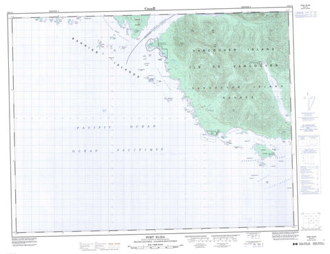
092E14 Port Eliza Canada topo map, 1:50,000 scale
092E14 Port Eliza NRCAN topographic map.
Includes UTM and GPS geographic coordinates (latitude and longitude). This 50k scale map is suitable for hiking, camping, and exploring, or you could frame it as a wall map.
Printed on-demand using high resolution, on heavy weight and acid free paper, or as an upgrade on a variety of synthetic materials.
Topos available on paper, Waterproof, Poly, or Tyvek. Usually shipping rolled, unless combined with other folded maps in one order.
- Product Number: NRCAN-092E14
- Parent Topo: TOPO-092E
- Map ID also known as: 092E14, 92E14
- Unfolded Size: Approximately 26" high by 36" wide
- Weight (paper map): ca. 55 grams
- Map Type: POD NRCAN Topographic Map
- Map Scale: 1:50,000
- Geographical region: British Columbia, Canada
Neighboring Maps:
All neighboring Canadian topo maps are available for sale online at 1:50,000 scale.
Purchase the smaller scale map covering this area: Topo-092E
Spatial coverage:
Topo map sheet 092E14 Port Eliza covers the following places:
- Cachalot Inlet - Esperanza Inlet - Kyuquot Bay - McLean Cove - Port Eliza - Rolling Roadstead - Volcanic Cove - Yellow Bluff Bay - Alert Point - Brecciated Point - Gregoire Point - Gross Point - Jurassic Point - Kapoose Point - Mushroom Point - Peculiar Point - Racoon Point - Robin Point - Rugged Point - Sandstone Point - Tatchu Point - White Cliff Head - Brown Channel - Clear Passage - Favourite Entrance - Gillam Channel - Kyuquot Channel - Kyuquot Sound - Nicolaye Channel - North Channel - Schooner Entrance - Yellow Bluff - Chiseuquis Indian Reserve 9 - Grassy Island Indian Reserve 17 - Occosh Indian Reserve 8 - Réserve indienne Chiseuquis 9 - Réserve indienne Grassy Island 17 - Réserve indienne Occosh 8 - Réserve indienne Tatchu 13 - Réserve indienne Tatchu 13A - Tatchu Indian Reserve 13 - Tatchu Indian Reserve 13A - Barrier Islands - Catala Island - Clark Island - Diver Islet - Eliza Island - Grassy Island - Highest Island - Île de Vancouver - Lookout Island - McQuarrie Islets - Mission Group - Moos Islet - Spring Island - The Twins - Thornton Islands - Twins Islands - Union Island - Vancouver Island - Volcanic Islets - Anvil Peak - Eliza Dome - Eliza Ears - Kyuquot Hill - Leading Hill - Newton Hill - Remarkable Cone - Ship Peak - Stone Nipples - Vancouver Island Ranges - Regional District of Comox-Strathcona - Catala Island Marine Park - Rugged Point Marine Park - Rugged Point Park - Anvil Creek - Cachalot Creek - Eliza Creek - Kapoose Creek - Narrowgut Creek - Park River - Porritt Creek - Sandpiper Creek - Tatchu Creek - Arnold Rock - Black Rock - Blind Reef - East Entrance Reef - Entrance Reef - Grogan Rock - Halftide Reef - High Rocks - Kapoose Rocks - Kate Rocks - Low Rock - Mid Rock - Middle Reef - Minx Rocks - Munsie Rocks - Nipple Rock - Nipple Rocks - Obstruction Reef - Outer Black Rock - Sail Rock - Tatchu Rocks - Twin Rocks - West Entrance Rock - West Rocks - White Rock


