
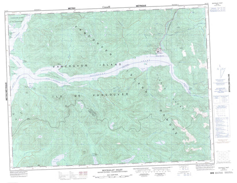
092E09 Muchalat Inlet Canada topo map, 1:50,000 scale
092E09 Muchalat Inlet NRCAN topographic map.
Includes UTM and GPS geographic coordinates (latitude and longitude). This 50k scale map is suitable for hiking, camping, and exploring, or you could frame it as a wall map.
Printed on-demand using high resolution, on heavy weight and acid free paper, or as an upgrade on a variety of synthetic materials.
Topos available on paper, Waterproof, Poly, or Tyvek. Usually shipping rolled, unless combined with other folded maps in one order.
- Product Number: NRCAN-092E09
- Parent Topo: TOPO-092E
- Map ID also known as: 092E09, 92E9, 92E09
- Unfolded Size: Approximately 26" high by 36" wide
- Weight (paper map): ca. 55 grams
- Map Type: POD NRCAN Topographic Map
- Map Scale: 1:50,000
- Geographical region: British Columbia, Canada
Neighboring Maps:
All neighboring Canadian topo maps are available for sale online at 1:50,000 scale.
Purchase the smaller scale map covering this area: Topo-092E
Spatial coverage:
Topo map sheet 092E09 Muchalat Inlet covers the following places:
- Camp Bay - Galiano Bay - Hisnit Inlet - Jacklah Bay - Matchlee Bay - Mooyah Bay - Muchalat Arm - Muchalat Inlet - Sydney Inlet - Three Bay Cove - Tlupana Arm - Tlupana Inlet - Valdes Bay - Anderson Point - Argonaut Point - Atrevida Point - Concepcion Point - Descubierta Point - Guaquina Point - Ous Point - Princess Royal Point - Hanna Channel - King Passage - Williamson Passage - Zuciarte Channel - Ahaminaquus Indian Reserve 12 - Cheesish Indian Reserve 15 - Hleepte Indian Reserve 14 - Kishnacous Indian Reserve 29 - Matchlee Indian Reserve 13 - Mooyah Indian Reserve 16 - Ous Indian Reserve 17 - Réserve indienne Ahaminaquus 12 - Réserve indienne Cheesish 15 - Réserve indienne Hleepte 14 - Réserve indienne Kishnacous 29 - Réserve indienne Matchlee 13 - Réserve indienne Mooyah 16 - Réserve indienne Ous 17 - Bligh Island - Gore Island - Île de Vancouver - Vancouver Island - Victor Island - Hesquiat Lake - Irving Lake - Lillian Lake - Pretty Girl Lake - Star Lake - Bury Peak - Crumble Mountain - Leading Mountain - Mills Mountains - Mills Peaks - Mount Adair - Mount Albemarle - Mount Albermarle - Mount Crespi - Mount Gore - Mount Powell - Mount Rufus - Mount Seghers - Mount Serjeant - Pierce Range - Sydney Cone - Ucona Mountain - Vancouver Island Ranges - Regional District of Alberni-Clayoquot - Regional District of Comox-Strathcona - Hesquiat Lake Park - Ahaminqas Creek - Black Creek - Burman River - Cascade Creek - Cougar Creek - Deer Creek - Deserted Creek - Escalante River - Flash Creek - Gold River - Houston River - Jacklah River - Kleeptee Creek - Matchlee Creek - McCurdy Creek - Megin River - Mooyah River - Nesook River - Pamela Creek - Quatchka Creek - Satchie Creek - Satchie River - Silverado Creek - Sydney River - Talbot Creek - Ucona River - Wilson Creek - Camel Rock - Mooyah Bay - Muchalat - Gold River


